
Landscape Susceptibility in relation to Energy Generation, Storage and Transmission - SPD
3.1 Approach View responses
3.1.1 The methodology for undertaking the Landscape Susceptibility Study (LSS) is based on the process set out in An approach to landscape sensitivity assessment – to inform spatial planning and land management (ALSA), Natural England, June 2019[4]. Reference was also made to Guidelines for Landscape and Visual Impact Assessment, Landscape Institute and Institute of Environmental Management and Assessment, 3rd Edition, April 2013 (GLVIA) and Topic Paper 6: Techniques and Criteria for Judging Capacity and Sensitivity, Countryside Agency and Scottish Natural Heritage, 2002.
3.1.2 The development of the methodology was informed by similar studies carried out by The Landscape Partnership in the past. It also took account of principles expounded in the Holford Rules (regarding the routing of overhead transmission lines) and the Horlock Rules (regarding the siting of substations, etc.).
3.1.3 The European Landscape Convention promotes achieving "sustainable development based on a balanced and harmonious relationship between social needs, economic activity and the environment".[5]
3.1.4 The ALSA notes:
Landscape sensitivity may be regarded as a measure of the resilience, or robustness, of a landscape to withstand specified change arising from development types or land management practices, without undue negative effects on the landscape and visual baseline and their value – such as changes to valued attributes of baseline landscape character and the visual resource. Landscape sensitivity assessment is a process that assesses the resilience/robustness of landscape character and the visual resource – and what we value - to a defined change, or changes. It can help decision makers to understand likely changes and the nature of change should particular courses of action - the development/land management scenarios – be taken forward. [page 5]
3.1.5 ASLA and GLVIA adopt a similar basic approach to the assessment of sensitivity, i.e. that sensitivity is a product of:
- the susceptibility of a landscape or visual baseline to a specific change; and
- the value of the landscape and its visual characteristics.
3.1.6 However, there are some important distinctions to be made in terms of how sensitivity is considered by ALSA, compared to the approach within GLVIA:
- In GLVIA terms, sensitivity, and in particular susceptibility to change, is considered with regard to a known development, whereas ALSA allows a more strategic assessment of landscape sensitivity, and it's the principle of a particular type of development change scenario that is considered.
- Within the context of spatial planning, landscape sensitivity refers to landscape character and the associated visual resource. Whereas GLVIA considers the landscape character and visual effects separately.
3.1.7 For the purposes of landscape sensitivity assessments, landscape sensitivity can be considered as a measure of "the resilience, or robustness, of a landscape to withstand specified change arising from development types or land management practices, without undue negative effects on the landscape and visual baseline and their value."
3.1.8 Historically, there has been some confusion concerning the use of the words sensitivity and capacity, and on occasions the two `terms have been used interchangeably. The ASLA notes:
Sensitivity and capacity have different meanings. When dealing with an area's sensitivity the question is, 'to what'? When dealing with an area's landscape capacity perhaps to absorb a certain amount of development without unacceptable changes to landscape character – the question generally relates to, 'how much'? Importantly, a sensitivity study will identify areas of relative sensitivity to particular development scenarios, and inform place based objectives and guidance and possibly decisions concerning environmental capacity - perhaps by way of what some might call a Landscape Capacity Assessment. The latter might help decision makers to set more detailed objectives about the amount of acceptable change within a specified area, and therefore inform a more detailed strategy regarding desired amounts of development / change.
3.1.9 The ASLA requires that the landscape sensitivity assessment process should "enable associated decision making to be sequential, transparent and auditable."
3.1.10 Similarly, Topic Paper 6 noted that landscape sensitivity relates to "the stability of character, the degree to which that character is robust enough to continue and to be able to recuperate from loss or damage. A landscape with a character of high sensitivity is one that, once lost, would be difficult to restore; a character that, if valued, must be afforded particular care and consideration in order for it to survive."[6]
3.2.1 The sensitivity of a landscape or visual receptor is determined by combining the value afforded to the receptor with its susceptibility to change.
3.2.2 Landscape value is based on considerations such as landscape quality/condition; landscape fabric and rarity; scenic quality; wildlife, heritage and cultural interest; recreation value; and perceptual aspects. The presence of a landscape designation can help to identify value and reasons for a designation are usually established in a supporting study. Landscapes or features without any formal designation may also express characteristics that are valued locally. Where there is no supporting evidence base, details regarding sensitivity should typically be derived from landscape character assessments.
3.2.3 Susceptibility to change assesses the relative ability of a landscape to accommodate the changes that would result from a particular type of development. This is an integral element of the landscape assessment but one that can only be judged in the context of the generic type of development being proposed. However, it is not necessary to understand the specifics of the development to make this judgement and thus susceptibility to change can be considered as part of the baseline assessment.
3.2.4 This LSS assesses the susceptibility of the different landscapes within the South Norfolk district to change from a range of energy-related development scenarios defined at Section 4.
3.2.5 It considers the susceptibility of the landscape types (LTs) landscape character areas (LCAs) defined in the South Norfolk Landscape Character Assessment to each of the generic development scenarios, assuming it is constructed somewhere within the LT or LCA. It does not consider the precise location of each scenario within the LT or LCA; however, where relevant, commentary is provided if particular parts of an LT or LCA might be more sensitive to a development scenario than others.
3.2.6 The LSS does not consider the landscape value of the various LTs and LCAs within the district. This would be a separate, further exercise. Combining such information with the corresponding susceptibility to change, using professional judgement, would give an overall landscape sensitivity.
3.2.7 As a broad generalisation, some initial indication of the value of a landscape can be ascertained by the presence (or not) of any landscape-related designations encompassing all or part of a particular LCA. Such landscape-related designations are illustrated at Appendix 1 | Figures 03-05 and where relevant the presence of such designations has been referenced in the study findings.
3.3 The study area View responses
3.3.1 The study area comprises the whole of the district of South Norfolk except for the areas which fall within the Broads Authority Executive Area.
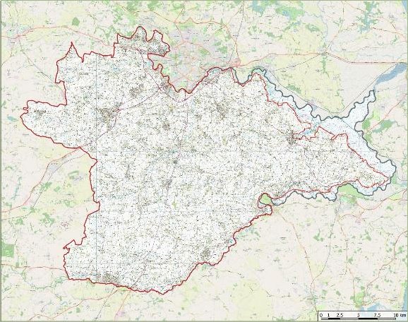
Map of the Study Area within South Norfolk District. This map illustrates the study area within the South Norfolk District Administrative Boundary. The area includes the entire district except for the areas that fall under the Broads Authority Administrative Area, which are excluded from the study. The South Norfolk Administrative Boundary is shown in red. Refer to Appendix 1, Figure 01 for detailed legend and scale.
3.3.2 The importance of understanding the landscape character of all landscapes in England is recognised in the National Planning Policy Framework (NPPF) §187, which states that planning policies and decisions should contribute to the natural environment by: "recognising the intrinsic character and beauty of the countryside, and the wider benefits from natural capital and ecosystem services – including the economic and other benefits of the best and most versatile agricultural land, and of trees and woodland".
3.3.3 The LSS considers the susceptibility of the different landscapes within South Norfolk district to various energy-related development scenarios.
3.3.4 Since different landscapes are defined by different physical and perceived qualities and attributes, it is likely that they will have differing resilience to a particular form of development. For example, a rural landscape could more readily accommodate a traditional barn, without changing the character of the area, whereas other types of development such as a distribution warehouse could potentially result in a significant change to the character of the landscape.
3.3.5 To understand the different effects that the various development scenarios would have on the different landscapes within the district it was first necessary to define geographical areas of common landscape character and qualities.
3.3.6 Landscape character assessment is the process that can identify these intrinsic values and unique characteristics of the diverse landscapes within a given area, in this case South Norfolk district. It enables landscapes to be described and understood by mapping natural, physical and cultural features in order to define different landscapes and demonstrate what makes them special. These landscape character types share similar characteristics, such as underlying geology, soil type, topography and landform, the pattern and type of land/field enclosure, historic land use, the pattern of settlements and types of building that these comprise, tree and woodland cover and the general visual experience of the area.
3.3.7 It is important to note that landscape character assessments can be undertaken at a range of scales. It should also be noted that boundaries are only indicative of the change between areas and therefore when working at a site scale, especially close to boundaries between character types or character areas, users should carefully identify which landscape the land parcel belongs to, based on its characteristics. In addition, it is important to note that while drawn with a line on a map, areas close to boundaries often may be better thought of as an area of transition and may display some of the characteristics and sensitivities of both character areas.
3.3.8 Effects on landscape character can be direct (i.e. on the character area/landscape type that the site is located within) or indirect (i.e. changes to characteristics or perceptions of character that occur beyond the boundary of a character area/landscape type). In addition, effects on landscape character may be positive, neutral or negative, i.e. strengthening and enhancing the characteristic patterns and features, or eroding and losing the patterns and features that contribute to landscape character.
3.3.9 The landscape of South Norfolk has been characterised in the published South Norfolk Landscape Character Assessment, Volume 4: Landscape Character of the Rural Policy Area, dated April 2006 (final amendments January 2008). The specific purpose of the report was to "provide a clear understanding of the character of the landscape within the Rural Policy Area. In particular, the assessment process aims to describe the distinctive features or characteristics that are important to the landscape and to provide guidance on those aspects of the landscape that are most sensitive to change" (§1.6).
3.3.10 The South Norfolk Landscape Assessment describes a total of seven landscape types (LTs) within the district:
A: Rural River Valleys
B: Tributary Farmland
C: Tributary Farmland with Parkland
D: Settled Plateau Farmland
E: Plateau Farmland
F: Valley Urban Fringe
G: Fringe Farmland
3.3.11 The seven LTs have been broken down into 20 geographically discrete landscape character areas (LCAs):
A1: Tas Rural River Valley
A2: Yare/Tiffey Rural River Valley
A3: Tud Rural River Valley
A4: Wensum Rural River Valley
A5: Waveney Rural River Valley
B1: Tas Tributary Farmland
B2: Tiffey Tributary Farmland
B3: Rockland Tributary Farmland
B4: Waveney Tributary Farmland
B5: Chet Tributary Farmland
B6: Yare Tributary Farmland
C1: Yare Tributary with Parkland
C2: Thurlton Tributary Farmland with Parkland
D1: Wymondham Settled Plateau Farmland
D2: Poringland Settled Plateau Farmland
E1: Ashwellthorpe Plateau Farmland
E2: Great Moulton Plateau Farmland
E3: Hingham Mattishall Plateau Farmland
F1: Yare Valley Urban Fringe
G1: Easton Fringe Farmland
3.3.12 It is these LCAs that are used to provide the areas of common landscape character whose susceptibility to change is assessed within the LSS, i.e. the baseline units for further analysis. The LCAs are mapped below and at Appendix 1 | Figure 08.
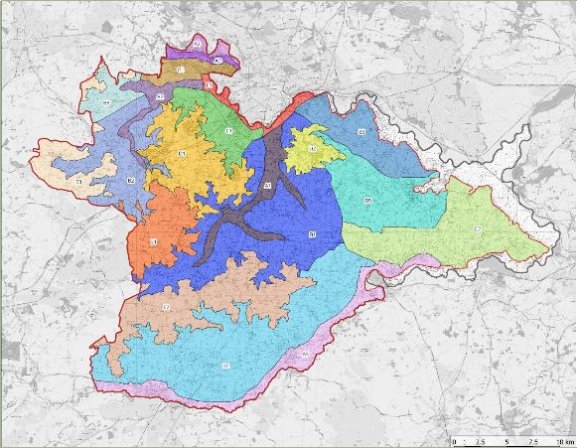
Landscape Character Areas in South Norfolk District. This map displays the Landscape Character Areas as defined by South Norfolk District Council. Each area is represented in a distinct colour and labelled with a unique code to differentiate between the various landscape types across the district. Refer to Appendix 1, Figure 08 for detailed legend and scale.
3.4 Desktop Appraisal / sources of information View responses
3.4.1 A desk-based study was undertaken that involved gathering and reviewing current and background information, including previous studies, environmental designations and other relevant baseline information. This included reference to:
- Natural England's National Character Area Profiles
- South Norfolk Landscape Character Assessment, 2008
- South Norfolk Local Plan
- South Norfolk Landscape Designations Review – Norwich Southern Bypass Landscape Protection Zone, 2012
- South Norfolk Landscape Designations Review – Landscape Character Areas & River Valleys in the Norwich Policy Area, 2012
- South Norfolk Landscape Designations Review – Local Designations Review, 2012
- South Norfolk District Landscape Sensitivity Study in relation to wind turbines, 2008
3.4.2 GIS data used for the LSS included OS map data, landscape-related designations, hydrology data, ecology designations (SSSI, NNR) and habitat data, heritage designations (both statutory and local, including Conservation Areas and Registered Parks and Gardens).
3.4.3 Reference was also made to Norfolk County Council's interactive map (Public Rights of Way, highways, etc.) and to the Government's Magic Map (landscape-related designations, etc.).
3.4.4 The baseline appraisal is presented as a collection of figures that can be found at Appendix 1 to the LSS.
3.4.5 The assessment findings should be read in conjunction with the figures within Appendix 1.
3.5 Sensitivity analysis View responses
3.5.1 The sensitivity of each of the LCAs, for each of the development scenarios, was assessed using a combination of desktop analysis and field work. The South Norfolk Landscape Character Assessment was used to establish the key characteristics of each LT and LCA.
3.5.2 The field survey work was carried out by a team of Landscape Architects, all of whom were experienced in the special qualities of South Norfolk's landscape, using a standard proforma to record data in a consistent manner.
3.5.3 Where appropriate, field notes were made to form the basis of guidance as to how the form of development might be adapted to make it more acceptable within the landscape and of any broad mitigation measures that might be appropriate to offset landscape effects or opportunities for landscape enhancements that might be delivered with development of the type proposed.
Approach to assessing the susceptibility of the landscape to change
3.5.4 The susceptibility of each LCA to the different energy-related development scenarios (as set out at Section 4) was assessed using a standard set of criteria. The criteria which were chosen reflected both the national guidance provided by Natural England and the particular circumstances of the South Norfolk landscape.
3.5.5 Each criterion was accompanied by a set of indicators of change to help guide the assessor in making judgements as to what factors should be considered to indicate a higher susceptibility to change and what factors a lower susceptibility.
3.5.6 The selection of landscape sensitivity indicators for this study was based on the attributes of the landscape that could be affected by energy developments. Energy developments can potentially affect the distinct and recognisable pattern of elements which create landscape character, as well as the perceptual and aesthetic qualities of the landscape.
3.5.7 The following criteria were used to assess susceptibility to change:
- Scale
- Enclosure
- Landform
- Field patterns
- Landcover
- Settlement pattern and human influence
- Perceptual aspects
- Visual characteristics
- Skylines
- Intactness
3.5.8 The criteria for assessing susceptibility to change were varied slightly, where appropriate, to suit the type of development under consideration. Separate criteria and indicators of susceptibility were therefore prepared for each of the development scenarios. These can be found at Appendix 2.
3.6 Assessment of overall susceptibility to change View responses
3.6.1 The susceptibility of the LCAs to each of the different development scenarios was assessed using a number of criteria. In each case susceptibility was assessed on a five-point scale of High, Medium-High, Medium, Medium-Low or Low. Commentary was also provided to explain the judgements. The findings of the assessments are recorded at Appendix 3. This allows the judgements made for each criterion to be viewed in a transparent, comparable and consistent manner.
3.6.2 Professional judgment was used to make an overall assessment of each LCA's susceptibility to change for each of the development scenarios, again using a five-point scale:
- Low susceptibility – Key characteristics and qualities are not vulnerable to change from this type of development. The landscape has a high potential to accommodate such development without causing a significant change in character. Care is still needed when siting and designing these developments to ensure best fit with the receiving landscape.
- Medium-Low susceptibility – Few of the key characteristics and qualities of the landscape are vulnerable to change. The landscape is likely to be able to accommodate new development with limited change in character. Care is still needed when siting and designing schemes to avoid adversely affecting local landscape character.
- Medium susceptibility – Some of the key characteristics and qualities of the landscape are vulnerable to change. Although the landscape may have some potential to accommodate development it is likely to cause a degree of change in character. Care would be needed in siting and design.
- Medium-High susceptibility – Key characteristics and qualities of the landscape are vulnerable to change. There may be some very limited potential to accommodate developments without significantly changing landscape character. Great care would be needed with siting and design.
- High susceptibility – Key characteristics and qualities of the landscape are highly vulnerable to change. New developments of this type are likely to result in a significant change in character. The LCA has low potential for development of this type.
3.6.3 Unless effective mitigations are being provided that reduce the harm, South Norfolk Council will use this SPD as evidence against proposals that it considers to be detrimental to landscape areas with a high susceptibility to change. This, in the Council's judgement, is necessary because harmful development without adequate mitigation is unacceptable, as the landscape is intrinsic to the area's beauty and should be safeguarded for generations to come.
3.7 Limitations View responses
3.7.1 In considering the findings of the LSS, the following limitations should be noted:
- It is important to remember that that landscape effects must be considered as a spectrum. There is no defined threshold that a development must reach in order to be considered acceptable against any of the criterion.
- When assessing the susceptibility of a landscape to change, consideration must be given to the effects of the development as perceived in neighbouring LCAs (and potentially further afield), not just the LCA in which the development is proposed.
- The landscape parcels, the LTs and LCAs, considered in the susceptibility appraisal are necessarily broad and in places extensive. As such, it is quite likely that that there are variations in susceptibility within a landscape parcel itself, with some areas of the parcel being more capable of accommodating a particular development scenario than others.
- The LSS considers only the attributes and characteristics of the landscape and their susceptibility to change. There may be other very good reasons why a particular site is unsuitable or inappropriate for development of the type proposed, for example it might have poor access or be subject to flood risk. It is quite possible that an area may have relatively low sensitivity to a particular form of development in landscape terms but would be unsuitable in other respects e.g. due to the presence of important ecological habitats. Identification of such matters are beyond the scope of this study.
- It is important to recognise that within the LSS no weighting has been applied to any of the individual criterion. The results as presented in the tables in Section 5 show the range of factors that have been considered for each landscape parcel or scenario and where they sit in the descriptive scale for each criterion. It is not the intention to add up the entries for each criterion to give an overall numerical score. Rather the tables aim to pictorially inform the descriptive text below each table. However, the relative importance of each criterion may vary between each landscape parcel for a range of reasons. Therefore, one should consider both the spread of criteria on the scale of factors and the contribution of each criterion.
3.7.2 The LSS provides an initial assessment of a landscape's ability to accommodate a particular type of development. Should any specific developments come forward, they would need to be tested through use of Landscape and Visual Impact Assessment to inform the emerging design and any mitigation measures necessary, and to determine any likely residual landscape and visual effects associated with that particular development proposal to assist those charged with determining the planning application.
[4] Tudor, C, Natural England, 2019
[5] Council of Europe (2000), European Landscape Convention, Council of Europe, Florence, October 2000
[6] Topic Paper 6 – Techniques for judging capacity and sensitivity