
Landscape Susceptibility in relation to Energy Generation, Storage and Transmission - SPD
7.1 Background View responses
7.1.1 Chapter 4.5 of the South Norfolk Local Plan Development Management Policies Document, Adopted October 2015, considers the landscape setting of Norwich. §4.53 notes that "As the dominant centre of the sub-region, the city of Norwich will continue to act as the focus of significant development pressures." Although the Norwich Policy Area is the preferred focus for growth, there has been a history of local planning policies designed to "protect the City's surroundings from "inappropriate development" and to "preserve those attributes of the City's natural setting which contribute to its environmental quality." In particular, there has been concern that "development pressure at the junctions on the Southern Bypass is not allowed to outweigh the environmental protection of important landscape characteristics in these locations."
7.1.2 The A47 Norwich Southern Bypass is recognised to have been "well designed to fit into the landscape through which it passes and it is accepted that it should not be regarded as a boundary up to which development is acceptable" [§4.54]. Within South Norfolk a Landscape Zone has been identified where there is a high level of visual accessibility to and from the bypass to a predominantly open rural area, that positively enhances the setting of Norwich.
7.1.3 Any development proposed within the landscape setting of Norwich will be assessed against South Norfolk Local Plan Development Management Policies Document, Policy DM 4.6: Landscape Setting of Norwich. This policy seeks to ensure that all development proposals will not harm and will, where possible, enhance the landscape setting of Norwich with regard to:
- the Norwich Southern Bypass Landscape Protection Zone (NSBLPZ)
- Key Views – identified long distance view cones into and out of the city
- Undeveloped Approaches to Norwich
- Gateways marking the arrival at and departure from Norwich
7.1.4 These designations are all as identified on the policies map as illustrated on the figure below. It is noted that "Development which would significantly harm the NSBLPZ or the landscape setting of the Norwich urban area will not be permitted."
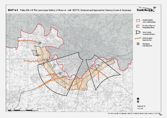
Map extract from the South Norfolk Development Management Policies Document, adopted October 2015 illustrating key elements of Policy DM4.6. This image shows a map extract from the South Norfolk Development Management Policies Document, adopted October 2015. It illustrates key elements of Policy DM4.6, which seeks to protect the landscape setting of Norwich. The map highlights the Norwich Southern Bypass Protection Zone (NSBPZ), showing undeveloped approaches, viewing cones, and key gateway locations. The legend identifies viewing cones with a solid black line, the protection zone with a hashed yellow line, gateways with a black circle containing an “X,” and undeveloped approaches with yellow and pink dashed lines.
7.2 Norwich Southern Bypass Landscape Protection Zone View responses
7.2.1 Policy DM 4.6 notes:
All development proposals within the Norwich Southern Bypass Landscape Protection Zone (NSBLPZ), as shown on the Policies Map, should have regard to protecting the openness of the Zone and, where possible, enhancing the landscape setting of the southern bypass, including the practice of wild flower planting and management regimes.
7.2.2 The supporting text notes [§4.56]:
A Landscape Zone has been identified where there are high levels of visual accessibility to and from the road to a predominantly open rural area that plays an important part in making the landscape setting of Norwich. This Zone does not have a distinct or special landscape character in its own right.
and [§4.58]:
Any development to be permitted within the Landscape Zone (including that within the highway and other transport corridors) should have regard to protecting the openness of the Landscape Zone and, where possible, enhancing the landscape setting of the Southern Bypass, including the practice of wild flower planting and management regimes.
7.2.3 Within South Norfolk, the Norwich Southern Bypass Landscape Protection Zone (NSBLPZ) encompasses land from Bawburgh in the north-west to Whitlingham in the east, following the edge of the city and the route of the bypass. In doing so, it encompasses land in the following LCAs:
- G1: Easton Fringe Farmland
- F1: Yare Valley Urban Fringe
- A2: Yare/Tiffey Rural River Valley
- C1: Yare Tributary Farmland with Parkland
- B1: Tas Tributary Farmland
- A1: Tas Rural River Valley
- B3: Rockland Tributary Farmland
Considerations for the LSS
7.2.4 The following paragraphs provide commentary on how the various development scenarios identified at Section 4 would accord with the objectives of the NSBLPZ.
7.2.5 Openness is understood to mean freedom from development and, as such, it is not possible to mitigate the effect on openness per se.
Solar PV
7.2.6 Solar PV projects tend to cover large areas and would therefore have a correspondingly large effect on the openness of the NSBLPZ. Although Solar PV projects retain the soil and vegetation cover beneath the panels, and are theoretically a temporary land use, they are nonetheless a form of development and represent an urbanising feature within the landscape. Solar PV then conflicts in principle with the aims of the policy. Whilst it is sometimes possible to screen Solar PV with planting this is less likely to be achievable in the NSBLPZ as the landscape zone encompasses the slopes of the Yare Valley. Screening is also made more difficult by embanked sections of the A47 which look across the Yare Valley.
AD plants
7.2.7 AD Plants include large structures and represent substantial developments. AD Plants therefore would be incompatible with maintaining the openness of the NSBLPZ, and would not enhance the setting of the bypass.
7.2.8 The landscape zone does however include occasional farms and AD Plants which are proposed for processing farm materials in a sustainable way should not be discouraged, as long as they are sited within the existing farmyard. Similarly, if an AD plant were to be proposed at the sewage works for the treatment of sewage it would be accepted that the location is determined by the existing infrastructure. Larger AD Plants, including those which process municipal waste, are not constrained in terms of their location, and there is no reason why they should be sited within the sensitive NSBLPZ.
Battery Storage
7.2.9 Battery Storage represents a smaller form of development, but would nonetheless compromise the openness of the NSBLPZ and the landscape setting of the bypass. Battery storage represents a type of infrastructure development which is at odds with the countryside. This form of development tends to have a utilitarian appearance which would not enhance the setting of the road. The effect could potentially be reduced by more appropriate rural forms of fencing, hedging, and by painting the cabinets dark green.
Overhead powerlines
7.2.10 Overhead powerlines have a small physical footprint which would not compromise the openness of the NSBLPZ. They would however have a negative effect on the views from the road to the surrounding countryside.
Underground cable routes
7.2.11 Underground cable routes would not affect the openness of the NSBLPZ. Whilst there might be some temporary visual effects which are experienced during installation this particular type of development would not alter the nature of the landscape zone.
Substations
7.2.12 Substations would by their nature affect the openness of the NSBLPZ and would introduce a strong developed character. If substations are located away from the existing urban edge this would tend to increase their impact as they would represent isolated development within the countryside.
7.3 Key Views View responses
7.3.1 Policy DM 4.6 notes:
All development proposals located within the Key Views 'cones' shown on the Policies Map should ensure they do not obstruct the long distance views to and from the City.
7.3.2 The supporting text notes [§4.59]:
The opportunities for long distance views into the city of Norwich from the south of the city are limited by the topography and screening effect of vegetation. However, fieldwork has identified important opportunities to view the city from the northern edge of the plateau to the south west and south east of the city. (These locations lie within the Landscape Character Areas of Wymondham Settled Plateau Farmland and Poringland Settled Plateau Farmland respectively.) In these areas, broad Key Views 'cones' have been identified (see Map DM 4.6). Within these 'cones' all development proposals should ensure they do not obstruct the long views to and from the city.
Considerations for the LSS
7.3.3 The following paragraphs provide commentary on how the various development scenarios identified at Section 4 would accord with the objective of the Key Views.
Solar PV
7.3.4 Given their height Solar PV panels are unlikely to completely obstruct views to or from Norwich.
AD plants
7.3.5 AD plants include large structures and clamps which are likely to obstruct views. Any proposed mitigation planting would further obstruct views.
Battery Storage
7.3.6 Battery storage tends to consist of low elements which are unlikely to completely obstruct views. Mitigation planting associated with a battery storage facility could however reduce views across the landscape. Battery storage may be visible in views from Norwich, particularly if it is located on the valley-side.
Overhead power lines
7.3.7 An overhead power line would detract from existing views but would not obstruct them per se.
Underground cable routes
7.3.8 An underground cable route would not obstruct views to or from Norwich.
Substations
7.3.9 Substations represent large developments with moderately tall structures which could potentially obstruct views to or from the city. Any proposed mitigation planting is likely to obstruct views.
7.4 Undeveloped Approaches to Norwich View responses
7.4.1 Policy DM 4.6 notes:
All development proposals on the approaches to defined Gateways (shown on the Proposal Map) shall reinforce and avoid undermining the significance of these Gateways as the visual points of the landscape and townscape change marking the 'arrival' at and 'departure' from the city of Norwich.
7.4.2 Policy DM 4.6 notes:
All development proposals within the visual zone of influence viewed from the identified Undeveloped Approaches to Norwich should reinforce and avoid undermining the rural character of the Undeveloped Approaches to Norwich.
7.4.3 The supporting text notes [para 4.60]:
There are several road and rail corridors approaching the city that have a very distinctive rural character and that afford views across the surrounding countryside and to Norwich. These Undeveloped Approaches are defined on the Proposal Map (and Map DM 4.6) as the full breadth of these transport corridors, but the Policy will ensure all development within the wider zone of visual influence visible from the transport corridors is designed to reinforce and avoid undermining the rural character experienced when travelling along the Undeveloped Approaches into Norwich.
Considerations for the LSS
7.4.4 The following paragraphs provide commentary on how the various development scenarios identified at Section 4 would accord with the objective of the undeveloped approaches.
Solar PV
7.4.5 Although Solar PV preserves the existing soils and vegetation cover beneath the panels it nonetheless represents a form of development. Whilst it might be possible to screen Solar PV from the undeveloped approaches this would not be within the spirit of maintaining a genuinely undeveloped approach.
AD plants
7.4.6 AD plants include large structures and clamps and are not compatible with the aims of the policy.
Battery Storage
7.4.7 Battery Storage represents a utilitarian form of development which is not compatible with the aims of the policy.
Overhead power lines
7.4.8 Overhead powerlines increase the sense of human influence and are a form of development. The existing land uses tend to remain the same below the powerlines so there would not be any direct effects on the undeveloped approaches.
Underground cable routes
7.4.9 Underground cable routes would have no perceived effect on the undeveloped approaches.
Substations
7.4.10 A substation would have a substantial negative effect on the undeveloped approaches. Whilst it may be possible to screen a substation with planting this would not be within the spirit of maintaining a genuinely undeveloped approach to the city.
7.5.1 Policy DM 4.6 notes:
7.5.2 All development proposals on the approaches to defined Gateways (shown on the Proposal Map) shall reinforce and avoid undermining the significance of these Gateways as the visual points of the landscape and townscape change marking the 'arrival' at and 'departure' from the city of Norwich.
7.5.3 The supporting text notes [para 4.61]:
In line with the Joint Core Strategy the submitted Norwich Local Plan has identified important Gateways where the landscape and townscape changes, marking the 'arrival' into Norwich urban area. South Norfolk Council has similarly identified three such points within the district.
Considerations for the LSS
7.5.4 The following paragraphs provide commentary on how the various development scenarios identified at Section 4 would accord with the objective of the gateways.
Solar PV
7.5.5 The gateways mark the transition from the countryside to the city. Development which alters the character of the countryside will similarly affect the character of the gateway and alter the sense of arrival. Solar PV is not particularly typical of the town or the countryside, and in this sense has a character of its own. Although Solar PV would not be perceived as an extension of the urban area it would have an adverse influence on the landscape setting of the city, which would make the gateway less effective.
AD plants
7.5.6 Farm-scale AD plants which are related to an existing farm would be seen as part of the countryside and would not therefore affect the gateway, which represents the transition from the rural area to the city.
7.5.7 Larger AD Plants clearly have a developed character which would compromise the landscape setting of the city, and the experience of the gateway. AD plants might be separated from the urban area itself, but would be seen as a type of urban fringe development which would create a poor entrance to the city.
Battery Storage
7.5.8 Battery storage installations have a developed, utilitarian character in common with other types of infrastructure. Battery storage would have a negative effect on the landscape setting of Norwich and the sense of transition which is represented by the gateway. Battery storage may however consist of lower elements which have some potential for screening.
Overhead power lines
7.5.9 Overhead powerlines are not seen as a form of urban development and would not alter the position of the gateway. Whilst overhead powerlines could alter the character of the countryside they would not affect the gateway as such.
Underground cable routes
7.5.10 Underground cable routes would not have any material effect on the gateways.
Substations
7.5.11 Grid and main substations are typically found on the edges of settlements and may be separated from the urban area (due to noise). The substations themselves include taller structures and security fencing and are urbanising features within the landscape. Substations therefore are likely to compromise the clean transition between the countryside and the urban area which is represented by the gateways. Substations offer limited opportunities for mitigation but could be screened with substantial planting.