
Landscape Susceptibility in relation to Energy Generation, Storage and Transmission - SPD
6.1.1 The following section provides a local level Landscape Character Assessment, to set out the key characteristics and special features of a 5km radius from Norwich Main (excluding the area beyond the district boundary). This will include a judgement on landscape value. The study area considers the published Landscape Character Assessments, to establish the landscape value and susceptibility to change, and therefore the resultant sensitivity of the landscape surrounding the Norwich Main substation.
6.2.1 The importance of understanding the landscape character of all landscapes in England is recognised in the National Planning Policy Framework (NPPF), which states [§187] that planning policies and decisions should contribute to the natural environment by: "recognising the intrinsic character and beauty of the countryside, and the wider benefits from natural capital and ecosystem services – including the economic and other benefits of the best and most versatile agricultural land, and of trees and woodland". Landscape character assessment is the process which can identify these intrinsic values and unique characteristics of the diverse landscapes in the UK.
6.2.2 Landscape character assessments enable landscapes to be described and understood by mapping natural, physical and cultural features in order to define different landscapes and demonstrate what makes them special. Landscape character types share similar characteristics, such as underlying geology, soil type, topography and landform, the pattern and type of land/field enclosure, historic land use, the pattern of settlements and types of building that these comprise, tree and woodland cover and the general visual experience of the area. Landscape character areas are specific geographic instances of a particular landscape type.
6.2.3 It is important to note that landscape character assessments can be undertaken at a range of scales. It should also be noted that boundaries are only indicative of the change between areas and therefore when working at a site scale, especially close to boundaries between character types or character areas, users should carefully identify which landscape the land parcel belongs to, based on its characteristics. In addition, it is important to note that while drawn with a line on a map, areas close to boundaries often may be better thought of as an area of transition and may display some of the characteristics and sensitivities of both character areas.
6.2.4 Effects on landscape character can be both direct, i.e. on the character area/landscape type that the proposed development is located within, and indirect, i.e. changes to characteristics or perceptions of character that occur beyond the boundary of a character area/landscape type. In addition, effects on landscape character may be positive or negative, i.e. strengthening and enhancing the characteristic patterns and features, or eroding and losing the patterns and features that contribute to landscape character.
6.2.5 The published LTs and LCAs from the national to the local levels within the Norwich Main 5km study area are summarised in the Table below.
Table 4: Hierarchy of Landscape Character Types and Character Areas
|
Level |
Landscape Character Type (LCT) |
Landscape Character Area (LCA) |
|
National: National Character Area (NCA) Profiles (Natural England 2014) |
Site sits within; Mid Norfolk NCA (84) |
|
|
Neighbouring; South Norfolk and High Suffolk Claylands NCA (83) |
||
|
District: South Norfolk Council - South Norfolk Landscape Character Assessment (2001) |
Site sits within; Tributary Farmland |
Site sits within; B1 Tas Tributary Farmland |
|
Neighbouring; River Valley Tributary Farmland with Parkland Settled Plateau Farmland |
Neighbouring; A1 Tas Rural River Valley C1 Yare Tributary Farmland with Parkland D1 Wymondham Settled Plateau Farmland D2 Poringland Settled Plateau Farmland |
6.2.6 This section seeks to assess the Landscape Character Areas surrounding Norwich Main, and provide an assessment of sensitivity to the different energy-related development scenarios, as set out above in section 4.1.
6.3.1 At the national level Norwich Main is located within NCA 84: Mid Norfolk. The broadly flat, rural landscape of the Mid Norfolk National Character Area (NCA) occupies the northern section of the East Anglian Plain, becoming more undulating to the north where it merges with the Central North Norfolk NCA in a curving line across the Wensum Valley, and more rolling towards Norwich to the east. This is ancient countryside with a long-settled agricultural character, where arable land is enclosed by winding lanes and hedgerows, interspersed with woodland and heath and dissected by lush pastoral river valleys. A patchwork of cultivated land, numerous church spires, distant wooded horizons and big skies dominate the landscape.
6.3.2 The NCA notes that 'The main pressures for change to the area are posed by growth and a need to accommodate increased development, especially around Norwich. The potential for further agricultural intensification and a need for sustainable approaches to commercial farming practices are also key challenges. Maintaining the traditional farmed landscape of Mid Norfolk NCA – through sustainable land management practice to help protect its important natural processes and resources, its areas of high tranquillity and enhance the natural landscape for recreational opportunity, geodiversity and biodiversity – is also presenting further challenges into the future.'
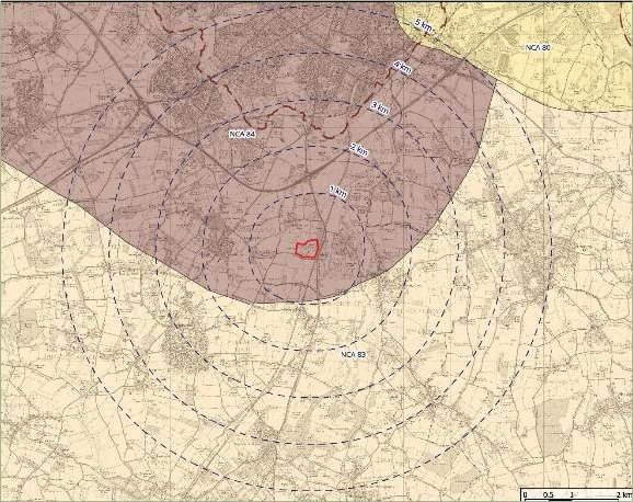
National Character Areas within 5km of Norwich Main. This map shows the National Character Areas (NCAs) that are located within a 5km radius of the Norwich Main substation, which is highlighted in red. Each NCA is colour-coded and corresponds to a specific landscape classification. Further details on these NCAs and a detailed legend can be found in Appendix 1, Figure 06.
6.3.3 Norwich Main is located close to the border with NCA 83: South Norfolk and High Suffolk Claylands, and can therefore is considered to occupy a zone of transition, at the national level.
6.3.4 The South Norfolk and High Suffolk Claylands occupy a large area of central East Anglia between the Yare Valley in the north and the Gipping Valley in the south. The area is defined by the underlying clay soils which contrast with the sandy soils of Breckland (to the west) and the Sandlings (to the East). The area was formerly well-wooded and was dominated by wood-pasture and dairy farming. The Napoleonic Wars, at the turn of the C19, coincided with the introduction of underdrainage. Because of the war wheat prices rose dramatically and the area switched to arable farming. Many of the woodlands and individual trees were removed in the C19, and the C20 has seen further hedgerow loss. The central clay belt within the county was traditionally referred to as High Suffolk (in contrast to the Brecklands and the Sandlings). The character area consists of a predominantly flat clay plateau which is incised by numerous small-scale wooded river valleys with complex slopes. The underlying chalk bedrock is overlain by a layer of glacial till. The Waveney, the largest of the NCA's rivers, forms the division between the counties of Norfolk and Suffolk. Most rivers however are small and slow following. The river valleys often contain a mosaic of habitats such as small-scale pasture or fens. Large areas of woodland are scarce within the current landscape.
6.3.5 The main pressures for change are described as the need to accommodate increased development in and around traditional centres, especially along the main transport corridors.
6.3.6 The landscape surrounding Norwich Main consists of arable farmland divided by native hedges, interspersed with small woods. It also contains historic lanes, while the settlement pattern consists of nucleated villages and isolated halls. It is therefore considered to be typical of both Mid Norfolk and the South Norfolk and High Suffolk Claylands NCAs.
6.4.1 Utilising the existing District Landscape Character Assessment, quotes and comments relating to susceptibility criteria and value characteristics are identified in Tables 01-10, Appendix 04.
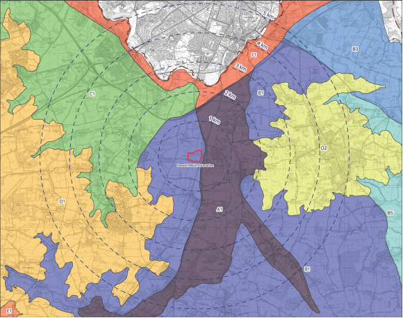
District Landscape Character Areas within 5km of Norwich Main Substation. This map presents the District Landscape Character Areas located within a 5km radius of the Norwich Main substation. Each area is shown in a distinct colour and labelled according to its landscape classification. The Norwich Main substation is highlighted in red for reference. A larger image and detailed legend can be found in Appendix 1, Figure 07.
6.4.2 At the district level the Norwich Main Substation is located within B1 Tas Tributary Farmland LCA. The Tas Tributary Farmland is a large area of land situated between the Tas Rural River Valley and the surrounding Plateau areas at an elevation of about 30m AOD to 50m AOD. See Tables 01-02, Appendix 04.
6.4.3 To the east of Norwich Main lies A1 Tas Rural River Valley LCA. The Tas Rural River Valley extends from Tasburgh in the south, to the Yare Valley in the north. The boundaries are defined topographically in relation to the top of the valley sides and roughly follow the 30m contour. See Tables 03-04, Appendix 04.
6.4.4 To the north west of Norwich Main lies C1 Yare Tributary Farmland with Parkland LCA. The Yare Tributary Farmland with Parkland occurs to the south west of Norwich and is defined by the rural and urban reaches of the River Yare to the east and north, and by the settled plateau farmland around Hethersett and Wymondham (above the 40m AOD contour) to the south. See Tables 05-06, Appendix 04.
6.4.5 To the south west of Norwich Main lies D1 Wymondham Settled Plateau Farmland LCA. The Wymondham Settled Plateau Farmland occupies an area to the southwest of Norwich, above contour level 40m AOD. It includes the towns of Wymondham and Hethersett. See Tables 07-08, Appendix 04.
6.4.6 To the east of Norwich Main and east of A1 Tas Rural River Valley LCA, lies D2 Poringland Settled Plateau Farmland. The Poringland Settled Plateau Farmland is defined by the 40m AOD contour. See Tables 09-10, Appendix 04.
6.5 Landscape Sensitivity of the LCAs surrounding Norwich Main View responses
6.5.1 The sensitivity of each of the five LCAs that fall within the Norwich Main study area, as set out above, was assessed using a combination of desktop and field work.
6.5.2 It is recognised that the South Norfolk Landscape Character Assessments' purpose is not to attribute relative values to different character area, in keeping with LCA guidance, which recognises that all landscapes are valued to some extent by some people, whilst the GLVIA guidance recognises that there are differences in value which will affect sensitivity, so some consideration of value is therefore required.
Susceptibility of the landscape to change
6.5.3 The susceptibility of each LCA to each of the different types of development proposed was assessed using a pre-defined set of criteria. These criteria reflect both the national guidance and the particular circumstances of the landscape the study area.
6.5.4 For each criterion, indicators of higher susceptibility and indicators of lower susceptibility were provided, to help guide judgements. The criteria, together with the indicators of susceptibility, are reproduced at Appendix 02.
6.5.5 To assess each LCA's susceptibility to change, certain assumptions were made. These were necessarily broad, since (as noted above) a Landscape Susceptibility Study assesses the principle of a particular type of development rather than a known development. For the purposes of this study, the extents and heights of the various types of energy related development are set out in section 4.1. The tables below provide some relative comparisons of known features within the region.
Table 5: Tall structures comparison
|
Structure |
Height |
|
Domestic Buildings |
6-10m |
|
Mature deciduous trees (depending upon species) |
10-25m |
|
Standard lattice tower 'pylons' |
15-55m |
|
Norwich Cathedral Spire |
96m |
Table 6: Comparative Areas
|
Land use |
Area (hectares) |
|
Typical football pitch |
0.6-0.8 ha |
|
Norwich Main Substation |
14 ha |
|
Dunston Hall Golf Course |
36 ha |
|
Approved solar array in Swainsthorpe, 49.9 MW - not yet constructed. |
79.6 ha |
6.5.6 The susceptibility of the landscape of each LCA to change from development of the type proposed was assessed against each of the specific criteria, using a five-point scale of High, High/Medium, Medium, Medium/Low or Low susceptibility to change.
Value
6.5.7 Value is an inherent quality of the baseline conditions, which is independent of the type of development proposed. GLVIA3 recognises that landscape value is not always signified by designation. Landscape value should be determined by a review of existing assessments and, where appropriate, by new analysis. The Landscape Institute Technical Guidance Note 02/21 sets out a range of factors that can be considered when assessing landscape value. The different aspects of value are natural heritage, cultural heritage, landscape condition, associations, distinctiveness, recreational, perceptual, and functional. The presentation of information about landscape value should be proportionate to the task at hand.
6.5.8 The landscape value of each LCA was assessed using a pre-defined set of criteria based on TGN 02/21. The LCA descriptions are drawn upon to identify any factors which add value either to the LCA or to particular elements within it. These might be special qualities associated with a designated landscape (e.g. AONB) or other aspects which could influence the sensitivity of the landscape to the identified energy related development.
6.5.9 The value of the LCA was assessed against each of the specific criteria, using a five-point scale of High, High/Medium, Medium, Medium/Low, Low value.
6.5.10 TGN 02/21 notes that "Value is best appreciated at the scale at which a landscape is perceived – rarely is this on a field-by-field basis." As such, the value judgements considered the sites and their landscape settings.
Sensitivity
6.5.11 The landscape units described in the district-level landscape character assessment have been used to provide the baseline data for assessing the sensitivity of the landscape character as they provide the most detailed assessment of landscape character available.
6.5.12 Landscape sensitivity is a product of susceptibility and value, and is expressed in the matrix below;
Table 7: Landscape Sensitivity
|
Criteria |
Value |
|||||
|
High |
Medium / High |
Medium |
Medium / Low |
Low |
||
|
Susceptibility |
High |
High |
High |
Medium / High |
Medium |
Medium |
|
Medium / High |
High |
Medium / High |
Medium / High |
Medium |
Medium |
|
|
Medium |
Medium / High |
Medium / High |
Medium |
Medium |
Medium / Low |
|
|
Medium / Low |
Medium |
Medium |
Medium |
Medium / Low |
Low |
|
|
Low |
Medium |
Medium |
Medium / Low |
Low |
Low |
|
6.6 Summary of LCA Sensitivity to Change View responses
6.6.1 The B1 Tas Tributary Farmland LCA has no national landscape designations, whilst it does contain designated ecological assemblages and a number of County Wildlife Sites, ancient woodland and medieval deer parks, the large scale hedgerow removal and modern development influence the overall quality of the landscape baseline, considered to be of Medium value. Within the eastern part of the LCA a large double line of overhead powerlines traverse the landscape, with Norwich Main substation to the north west of the LCA, a large solar PV development approved (not yet under construction) to the south west, and large transmitting station west of Howe already have an adverse effect on landscape character by extending vertically above the wooded horizons, so sensitivity to modern development would be lower, but larger developments in terms of extent and vertical axis would be out of scale with the field pattern, landform and landcover.
6.6.2 Whilst this LCA may accommodate the small to medium-scale energy development scenarios, consideration must be made regarding cumulative impact, especially given the likelihood of requiring connection to the existing substation at Norwich Main, which is located within the north western part of this LCA.
6.6.3 The A1 Tas Rural River Valley LCA has no national landscape designations, whilst it does contain designated ecological assemblages including wet grassland and shallow fenland peat, the landscape remains predominantly pastoral with linear wet woodland following the river corridor, with good hedgerow network with mature trees, with the overall quality of the landscape baseline, considered to be of Medium-High value. The A140 runs along the upper slopes on the western side of the valley, adding noise and movement to the otherwise peaceful valley landscape. Overhead power lines and pylons, along with the mainline railway into Norwich, cross the northern extent of the LCA, with the Norwich Southern Bypass forming the northern limit of the character area, reducing sensitivity in these locations.
6.6.4 This LCA is a clearly defined flat valley floor with shallow side slopes, moderately wide and following a simple valley floor. The nature of much of the LCA is a scenic and largely tranquil rural landscape which would have a relatively high level of sensitivity to any distinctly modern development.
6.6.5 The C1 Yare Tributary Farmland with Parkland LCA has no national landscape designations, whilst it does contain a Registered Park and Garden, Intwood Hall, the landscape presents a variety of more intimate landscape settings, with many estates and historic parklands, with a sparse hedgerow and hedgerow tree network, with occasional mature / veteran oaks forming distinctive features along the lanes. The overall quality of the landscape baseline is considered to be of Medium-High value. The Norwich Southern Bypass and A11 trisect the landscape, along with the Great Eastern Main Line, creating corridors of noise and movement within the otherwise peaceful landscape.
6.6.6 This LCA is a peaceful farmland landscape with small farm woodlands and intermittently wooded tributary valleys creating a quiet rural atmosphere. The nature of much of the LCA is a scenic and largely tranquil rural landscape, with a high preponderance of large parkland estates, tree-lined avenues and traditional wooded parkland.
6.6.7 The D1 Wymondham Settled Plateau Farmland LCA has no national landscape designations, whilst it does contain areas of ancient woodland and some village ponds, the landscape generally presents as large expanses of arable plateau, with little variation, with long views afforded from the plateau edge. The overall quality of the landscape baseline is considered to be of Medium value. The A11 bisects the landscape, creating a corridor of noise and movement. This study area does not extend beyond the A11, to the north of which, between Norwich, Hethersett and Wymondham is an area designated as Strategic Gap.
6.6.8 This LCA is a settled landscape with large edge of plateau towns and villages with smaller settlements dispersed across the plateau. The nature of much of the LCA is of a large scale open arable landscape often monotonous character due to the large scale arable monocultures.
6.6.9 The D2 Poringland Settled Plateau Farmland LCA has no national landscape designations, whilst it does contain areas of ancient woodland and some moats, the landscape generally presents as large scale arable plateau, with a wooded character to the north of the LCA and around settlements. Long views are afforded from the plateau edge towards Norwich and to the Tas Valley. The overall quality of the landscape baseline is considered to be of Medium value. The large telecommunications towers (radio and radar) located at the high point of the plateau in Caistor St Edmund, are visible from a large area, extending above wooded horizons.
6.6.10 This LCA has a densely settled core area, with ribbon development interconnecting to other village cores. The long distance national trail of Boudica's Way cuts across the LCA leading towards the Tas Valley. The nature of much of the LCA is of a large scale open arable landscape, with reduced levels of tranquillity near settlements.
6.6.11 Consideration must be made regarding cumulative impact, especially given the likelihood of requiring connection to the existing substation at Norwich Main, which is located within the Tas Tributary Farmland LCA.
6.6.12 The assessment of landscape value is summarised below. Landscape value can be combined the judgements on susceptibility in Tables 1-3 to arrive at a judgement on the sensitivity of the LCA to a particular type of development.
Table 8: Landscape value
|
Landscape Character Area |
Landscape value |
|
B1: Tas Tributary Farmland |
Medium |
|
A1: Tas Rural River Valley |
Medium-High |
|
C1: Yare Tributary Farmland with Parkland |
Medium-High |
|
D1: Wymondham Settled Plateau Farmland |
Medium |
|
D2: Poringland Settled Plateau Farmland |
Medium |