Village Clusters Housing Allocations Plan - Alternative Sites & Focused Changes (Reg. 18)
4. Bawburgh
Form and character
4.1. Bawburgh is situated in the bottom of the Yare Valley between the B1108 and A47. Two distinct settlement groups have developed each side of the river. To the south of the river, frontage development extends along Church Street towards the church; more recent estate development is situated on Hockering Lane, with a detached group of dwellings further south beyond the village hall on Stocks Hill. To the north of the river, frontage development follows the line of New Road and Harts Lane, with another nucleus of dwellings to the west of the junction with Marlingford Road.
4.2. The central area of the village is designated as a Conservation Area in. The floodplain of the River Yare between the two 'sides' of the village has remained undeveloped. This contributes to the valley setting of Bawburgh.
Services and Community Facilities
4.3. Bawburgh has a range of facilities including the primary school, village hall and public house. There is an infrequent bus service to Wymondham.
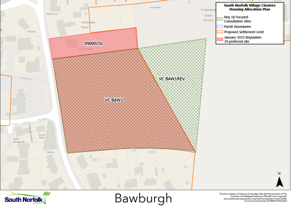
Settlement Limit
4.4. The Settlement Limit is divided by the river which runs through the centre of the village. The northern section includes almost all dwellings on New Road and Harts Lane, including the small cluster of development at the junction with Marlingford Road. The southern section includes most buildings on Church Street and Hockering Lane but excludes the church itself. The Settlement Limit has been extended to the south along Stocks Hill, incorporating both recent development to the west at Saint Walstan Meadow and established development to the east. There is also a small addition to the Settlement Limit adjacent to the northern boundary of the VC BAW1 allocation.
Site allocations and options
VC BAW1 REV, Land to the east of Stocks Hill, Bawburgh
4.5. The January 2023 Regulation 19 document included an allocation of 1.40ha of land for up to 35 dwellings east of Stocks Hill, Bawburgh, VC BAW1. It is proposed to retain and revise this allocation.
4.6. Responses to the Regulation 19 document raised several concerns about the development of VC BAW1, which are set out in the December 2023 Statement of Consultation, available in the Supporting Documents to this consultation. Whilst the Council considers that most of these concerns can be addressed without changing allocation VC BAW1, this consultation is being used to address the density of proposed development on the allocation. Many respondents suggested that 35 dwellings on a 1.4ha site would be out of character with a village location, be incompatible with other recent developments on the approach to the Conservation Area, and would limit the options in terms of form and scale of dwellings, specifically the ability to deliver bungalows. As such VC BAW1 REV is proposed, to extend the site to 1.9ha, whilst retaining it for up to 35 dwellings. This would give scope for future proposals to address the village location, adjoining Conservation Area and the wider river valley landscape in a more sympathetic way.
4.7. Please note that the Council does not propose to change any other aspects of the Regulation 19 Policy for VC BAW1 REV, other than the site area. The original Policy wording can be seen here: https://southnorfolkandbroadland.oc2.uk/document/12/1228#d1295.