Village Clusters Housing Allocations Plan - Alternative Sites & Focused Changes (Reg. 18)
9. Spooner Row and Suton
Form and character
9.1. The village has developed as four significant settlement groupings, with the Norwich to Ely railway line and agricultural land separating the groups. The open spaces between these settlement groups contribute to the character of the village. To the north-east, across the A11, is Suton which is a small hamlet. There are minor road connections to the A11 providing access to Attleborough, Wymondham and Norwich.
Services and Community Facilities
9.2. The village hall, rail halt and primary school are in the School Lane/Station Road cluster, while there is a pub on the crossroads to the east. Suton has preschool facilities. Spooner Row has a railway station with one train a day to Norwich and Cambridge. There is also a regular bus service to Norwich, Wymondham and Attleborough, although these only stop on the B1172 across the A11, and several hundred metres from the central areas of the village.
Settlement Limit
9.3. The Settlement Limit has been drawn to include the main built form of the settlement but excludes the school playing field. As such, it appears in clusters, reflecting the dispersed nature of Spooner Row. The Settlement Limit has been updated to include development at The Ridings.
Site allocations and options
9.4. The January 2023 Regulation 19 document included four allocations in Spooner Row, two carried forward from the 2015 South Norfolk Local Plan, and two new allocations. These are:
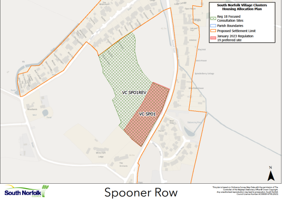
VC SPO1, Land west of Bunwell Road, Spooner Row. A new allocation of 0.76ha of land for approximately 15 dwellings. It is proposed to retain this allocation but also consider it for potential extension.
VC SPO2, South of Station Road, Spooner Row. A new allocation of 1.67ha of land for approximately 25 dwellings. It is proposed to retain this allocation unchanged.
VC SPO 3, Land at School Lane, Spooner Row. A carried forward 2015 Local Plan allocation of 0.3 hectares of land for up to 7 dwellings. This site is expected to be built out in accordance with the existing planning permission (2016/0627).
VC SPO4, Land at Chapel Road, Spooner Row. A carried forward 2015 Local Plan allocation of 0.6 hectares of land for up to 14 dwellings. This site is expected to be built out in accordance with the existing planning permissions (2014/2472, 2016/2424 & 2018/1622).
VC SPO1 REV, Land west of Bunwell Road, Spooner Row
Proposed for: VC SPO1 was included in the January 2023 Regulation 19 document as a proposed allocation of approximately 15 dwellings on 0.76ha of land. It is now proposed to extend the site to 2.34ha and increase the numbers to approximately 35 dwellings to create VC SPO1 REV.
Reasoned justification: During the Regulation 19 publication period, a larger site continued to be promoted for a higher number/density than was being supported by the Council. Whilst the promoted numbers were considered to be quite high due to the relatively limited services available in the area, as well as raising potential landscape and townscape concerns, the Council considers that a smaller increase in numbers would be appropriate and would result in a more effective use of land on a relatively well contained site. An area to the north of the site would remain outside of the allocation, due to the identified flood risk here and would help maintain the separation between groups of buildings, which is characteristic of Spooner Row.
The Regulation 19 Policy for VC SPO1 was written based on 15 dwellings on a notably smaller site area. As such, as well as changing the site area and dwelling number, the Policy will need to be updated in other respects too. The Regulation 19 wording can be seen here: https://southnorfolkandbroadland.oc2.uk/document/12/1228#d1760.

