Village Clusters Housing Allocations Plan - Alternative Sites & Focused Changes (Reg. 18)
10. Tacolneston and Forncett End
Form and character
10.1. The main concentration of development within the parish of Tacolneston is based along Norwich Road and adjoins the built-up area of Forncett End to the south. Development in the remainder of the parish comprises scattered individual dwellings and farmsteads. The village developed as a predominantly linear settlement along Norwich Road with the addition of post war estate development, namely at Dovedale Road, Boileau Avenue and off Bentley Road in Forncett End.
10.2. Further estate development exists at The Fields to the west of Norwich Road. A significant break in the built-up frontage on both sides of Norwich Road exists to the north of the Manor House buildings whose setting in spacious grounds with good tree growth contributes towards the 'open' nature and rural character of this part of the village. The area to the north of the estate development at Dovedale Road is designated as a Conservation Area and extends as far east as the church. This area has a distinctly rural character with mature trees.
10.3. In Forncett End ribbon of development has extended along Long Stratton Road to the east with development limited to the north side of the road east of Chestnut Tree Farm with the southern side largely undeveloped and fronting open fields. Development has also extended along the south side of West Road and along both sides of Tabernacle Lane as far as Elm Tree Farm.
10.4. The B1113 provides relatively good access to Norwich and New Buckenham whilst the B1135 runs to the north providing access to Wymondham and Long Stratton. The remainder of the parish is served by 'C' class and unclassified roads.
Services and Community Facilities
10.5. The parish has a range of social and community facilities including a primary school, pub, social club, takeaway restaurant, village hall and recreation facilities. There is a limited bus service to Norwich, Diss, Wymondham, Wreningham and East Harling.
Settlement Limit
10.6. Tacolneston has two separate areas contained within Settlement Limits. A Settlement Limit has been drawn to include the main built form of the settlement whilst a smaller Settlement Limit has been drawn around the estate development at Dovedale Road to the north of the village.
Site allocations and options
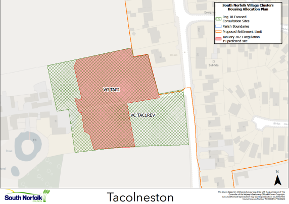
10.7. The January 2023 Regulation 19 document included two allocations at Tacolnestion. A new allocation of 0.6ha of land for up to 25 dwellings west of Norwich Road, Tacolneston, VC TAC1. It is proposed to retain this allocation but promote an amended boundary and change to the policy wording.
10.8. The second allocation was carried forward from the 2015 South Norfolk Local Plan, VC TAC2, Land adjacent The Fields, for approximately 21 dwellings on 0.95ha of land. It is proposed to retain this allocation.
VC TAC1 REV, Land to the west of Norwich Road, Tacolneston
Proposed for: VC TAC1 was included in the January 2023 Regulation 19 document as a proposed allocation of up to 25 dwellings on 0.6ha of land. The site was higher density, but reflected the particular aspirations of the site promoter. It is now proposed to extend the site to 1.0ha and change the wording from 'up to 25 dwellings' to 'approximately 25 dwellings' to create VC TAC1 REV.
Reasoned justification: During the Regulation 19 publication period, concern was raised by Norfolk County Council about how the site access was illustrated in the Plan. Subsequently a planning application (2023/2234) has been submitted which largely mirrors the proposed VC TAC1 allocation. The application is for 29 affordable dwellings, alongside open space, landscaping and associated infrastructure. The application site is larger than the proposed allocation, at approximately 1ha, including an area to the southeast which takes the site up to the B1113. This latter point should address Norfolk County Council's concerns regarding access. This additional land already had planning permission for three bungalows, taking the capacity of the proposed allocation to around 28 dwellings. As such it is suggested the site be amended as VC TAC1 REV to reflect the area of the planning application and that the wording of the Policy be changed to 'approximately 25 dwellings'.
As well as changing the site area and amending the wording as noted above, the wording of Policy VC TAC1 may need to be updated in other respects. The Regulation 19 wording can be seen here: https://southnorfolkandbroadland.oc2.uk/document/12/1228#d1768.