Village Clusters Housing Allocations Plan - Alternative Sites & Focused Changes (Reg. 18)
3. Barnham Broom, Kimberley, Carleton F., Runhall and Brandon Parva
Form and character
Barnham Broom
3.1. The built-up area around Mill Road is set on a west-facing slope of part of the attractive Yare Valley. It is separated from the eastern part of the village by the significant wooded area south of St Michael's Church and open fields south of Norwich Road. The settlement form here is based on the junction of Mill Road and Bell Road, and estate-scale development has occurred between the two roads. To the east, the built-up area of Norwich Road is linear, with small cul-de-sacs at Chapel Close and Lincoln's Field.
3.2. Further east of the built-up area at Norwich Road is the detached farm hamlet of Pockthorpe, which is separated from the main part of the village by a significant open gap, with good views of the surrounding open countryside. Good road links exist to Norwich and Watton (B1108) and Wymondham and Dereham (B1135).
Services and Community Facilities
3.3. Barnham Broom has a good range of facilities including a primary school, village hall, pub, shop, and post office. Outside the village centre, the parish also contains Barnham Broom Golf & Country Club. There is a limited bus service to Norwich and Wymondham.
Settlement Limit
3.4. The Settlement Limit has been drawn in two parts to include the main built form of the settlement. There is a break in the Settlement Limit where agricultural land and woodland provide a rural setting for the village. As part of the preparation of this Plan two additional areas of land on Norwich Road have been incorporated into the Settlement Limit; however, these maintain physical separation between the two built up areas.
Site allocations and options
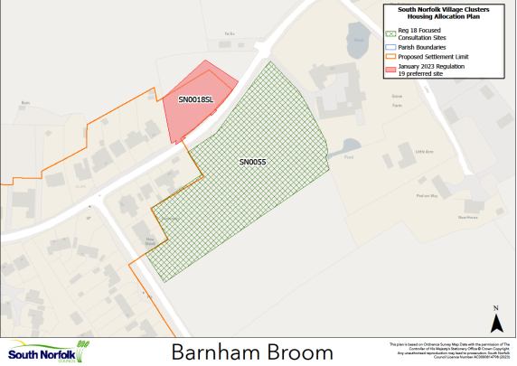
3.5. The January 2023 Regulation 19 document included an allocation of 1.40ha of land for approximately 40 dwellings at the corner of Norwich Road and Bell Road, Barnham Broom, VC BB1. It is proposed to retain this allocation.
3.6. An additional area of land is now being considered for allocation:
SN0055, Land east of Spur Road and south of Norwich Road, Barnham Broom
Proposed for: This site was previously classified as 'shortlisted' in the assessments supporting the January 2023 Regulation 19 publication. The site is now proposed as a possible allocation for approximately 15 dwellings on an area of 1.0ha.
Reasoned justification: The site is well located for services and facilities in Barnham Broom, although some localised footway improvements may be required. Highways access is considered to be achievable. Whilst the site is relatively rural in nature, it could be developed in a sympathetic manner at a lower overall density, respecting the neighbouring non-designated heritage asset. In addition, a site opposite (SN0018SL), which has previously been subject to a planning application for two dwellings, was included in the January 2023 Regulation 19 document as suitable for small-scale development as a Settlement Limit extension, which would also change the context of SN0055.