Village Clusters Housing Allocations Plan - Alternative Sites & Focused Changes (Reg. 18)
6. Earsham
Form and character
6.1. Earsham is located within the Waveney Valley approximately 1km south-west of Bungay and in close proximity to the Broads. The main area of development in the parish lies to the south of the modern A143 along The Street. Development elsewhere in the parish is of a scattered and sporadic nature.
6.2. The main built-up area of Earsham was originally based along the line of The Street with the core of the village centred on the crossroads of The Street and Station Road. Significant post-war development has resulted in a more nucleated settlement form. Earsham has good links, via the A143 with Beccles and Lowestoft to the east, and Harleston and Diss to the west, and to Norwich via the B1332. Part of the parish, to the north of the A143 bypass, lies within the Broads Authority area.
Services and Community Facilities
6.3. The settlement has a range of commercial, social and community facilities including a primary school, pub and village hall. Earsham is in close proximity to Bungay which provides a large range of social and community facilities. There is a regular bus service to Bungay, Beccles, Diss and Yarmouth.
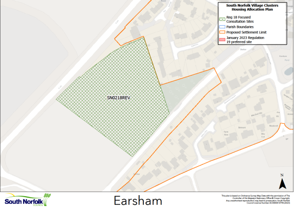
Settlement Limit
6.4. The Settlement Limit includes the main built form of the settlement and includes the new development at Granary Close, formerly the EAR1 allocation in the 2015 Local Plan.
Site allocations and options
6.5. The January 2023 Regulation 19 document included an allocation of 1.3ha of land for up to 25 dwellings on land East of School Road, Earsham, VC EAR1. It is proposed to retain this allocation.
6.6. An additional area of land us now being considered for allocation:
SN0218 REV, Land north of The Street, Earsham
Proposed for: This site was previously classified as 'shortlisted' in the assessments supporting the January 2023 Regulation 19 publication. The site is now proposed as a possible allocation for up to 25 dwellings on an area of 1.4ha.
Reasoned justification: The site is well located for services and facilities in Earsham, and at the previous Regulation 18 stage in 2021 was considered a preferred site. Whilst this site would increase numbers in the village to 50 dwellings, the settlement has both a range of local facilities, and good access (including almost continuous footway and a reasonable bus service) to a wider range of services and facilities in nearby Bungay. The two proposed allocation sites are well separated from each other within the village, reducing the immediate impacts of development.
The site is open to the west, with views from the main A143; however, the Landscape and Visual Appraisal (LVA) in the Supporting Documents notes that development would be read as an extension to the exiting settlement. The 1.4ha proposed for allocation also allows scope to incorporate landscaping and for a scale, form and density of development which would help mitigate any impacts. A suitable access appears achievable, and the existing speed management measures would be relocated west, to extend the 30mph speed limit. The main constraint to the site is the ability to create a footway which connects to existing provision on The Street, without impacting on the road width, which is required as part of the bus route.