Village Clusters Housing Allocations Plan - Alternative Sites & Focused Changes (Reg. 18)
Form and character
Alpington
1.1. The main built-up areas of Alpington and Yelverton form a contiguous settlement. Development is concentrated around Church Road and Wheel Road. There is also a significant area of development at Mill Road, Alpington. Small, detached clusters of development exist to the west of the main built-up area on Burgate Lane and to the south on Church Meadow Lane in Alpington, whilst a small number of individual dwellings and farmsteads are dispersed throughout the remainder of both parishes.
1.2. The settlement has developed as a ribbon form along Church Road and Wheel Road, though significant post-war estate scale development has taken place in the parish north of Wheel Road and west of Church Road, resulting in a more nucleated settlement form for this part of the settlement.
1.3. The settlement is set in generally flat open countryside, although in the south of Alpington there is a small area of attractive valley landscape. The village is characterised by good areas of tree and hedge planting especially along Church Road, which together with its setting and views of the surrounding countryside give it an attractive rural character.
1.4. The western limit of the village along Wheel Road / Burgate Lane is clearly defined by a significant tree belt on the north side of the road, which together with open fields on both sides of the road maintains the separation between the main village and the small cluster of dwellings to the west. The A146 is 1km (0.6 miles) to the north and provides a good link to Norwich and Loddon whilst the B1332 lies immediately to the west of the parish providing good links to services in Poringland and also to Norwich and Bungay.
Services and Community Facilities
1.5. The cluster's primary school lies at the main crossroads in Alpington. Further north on Church Road can be found the village hall, which also provides pre-school facilities, and Yelverton Football Club. There is a limited bus service to Norwich and Beccles. Alpington also has a pub on Wheel Road. A second village hall is located at Cookes Road, Bergh Apton and the local Post Office has moved to Green Pastures café and garden centre, adjacent to the A146.
Settlement Limit
Alpington
1.6. The Settlement Limit for Alpington and Yelverton has been drawn to include the main built form of the settlement and is centred around development along Church Road and Wheel Road, and the small, estate-scale developments north of Wheel Road and west of Church Road. Along Mill Road there is an area of development within Alpington Parish which is covered by the Bergh Apton Settlement Limit. As part of the preparation of this Plan a site located on land south of Bergh Apton Road and west of Nichols Road, adjacent to the Primary School, was promoted. Following an assessment of the site this land has been incorporated into the updated Settlement Limit.
Site allocations and options
1.7. The January 2023 Regulation 19 document included an allocation of 1.87ha of land for approximately 25 dwellings on Land west of Church Meadow, Alpington. Also within this cluster the document included an allocation for up to 25 dwellings at the Former Concrete Batching Plant, south of Church Road, Bergh Apton. It is proposed to retain both of these allocations.
1.8. An additional site is now being considered for allocation:
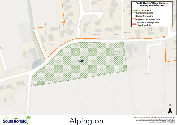
SN0433, Land south of Wheel Road, Alpington.
Proposed for: This site was previously classified as 'shortlisted' in the assessments supporting the January 2023 Regulation 19 publication. The site is now proposed for possible allocation for at least 12 dwellings on an area on 1.0ha.
Reasoned justification: The site is reasonably located in terms of local services and facilities and has few on-site constraints. Development would need to reflect the existing built form along Wheel Road.
The main concerns with the site relate to the provision of a suitable access from Wheel Road. The initial assessment of the site assumed a higher density of circa 25 dwellings, which would be likely to require removal of the substantial frontage hedge (with trees) in order to facilitate the necessary highways improvements. These highway improvements would affect the whole site frontage from the Reeders Lane/Burgate Lane junction (which itself would require improvement) to the Wheel of Fortune and would significantly change the character of the area and raise concerns in terms of wider landscape character.
The proposal is now for a significantly reduced level of development, potentially accessed via non-adopted roads. However, development of any scale on this site is likely to result in at least the partial loss of the frontage hedgerow. Therefore, key to the suitability of the site will be demonstrating that an appropriate access can be achieved which balances the need for additional housing along with the impacts on the character of the locality. Replacement planting to the front (north) and new planting to the rear (south) of the site could help mitigate the impacts.