Village Clusters Housing Allocations Plan - Alternative Sites & Focused Changes (Reg. 18)
2. Barford, Marlingford, Colton and Wramplingham
Form and character
Barford
2.1. Barford is a compact settlement on the north bank of the River Tiffey. Development has extended northwards away from the B1108 along Cock Street and Style Loke, with frontage development to the north of Church Lane and along Chapel Street/Marlingford Road. The historic centre of the village is concentrated on Cock Street and Chapel Street with later estate development situated off Chapel Street at Park Avenue and Clarke Close. The village is set in the attractive valley of the River Tiffey and is characterised by mature tree planting. The most sensitive area of the village is situated on either side of Cock Street where the Hall and its grounds on the west side and the popular plantation on the east side, positively contribute to the form and character of the village.
2.2. Barford has a good road link via the B1108 to Norwich 13km to the east and links via mainly unclassified roads to Wymondham 6km to the south.
Services and Community Facilities
2.3. Barford has a range of facilities including a village hall and the primary school. There are several industrial and commercial units located within the centre of the village, which provide local employment opportunities. There are also regular bus services to Norwich and an infrequent service to Wymondham. In addition, there are several specialty shops across the cluster's settlements.
Settlement Limit
Barford
2.4. A Settlement Limit has been drawn to include the main built form of the settlement. A smaller Settlement Limit has been drawn around the existing properties on Church Lane to the west of the village.
2.5. Much of the central part of Barford forms part of the Barford Flood Alleviation Scheme which helps to control flooding in the village. This has therefore constrained where development could be located in the village, and this area has been excluded from the Settlement Limit.
Site allocations and options
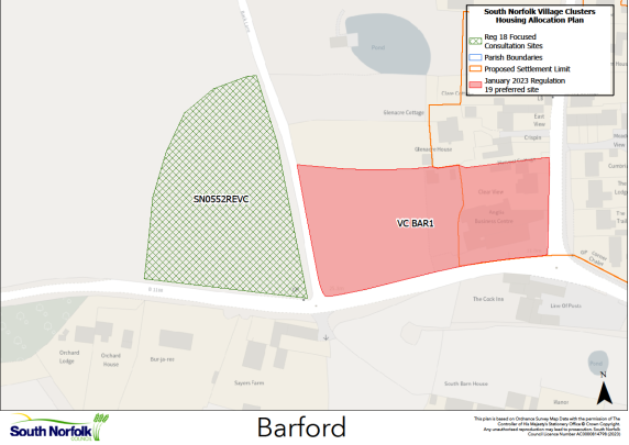
2.6. The January 2023 Regulation 19 document included an allocation of 0.76ha of land for approximately 20 dwellings on Land at Cock Street and Watton Road, Barford, VC BAR1. It is proposed to retain this allocation.
2.7. Two additional areas of land are now being considered for allocation:
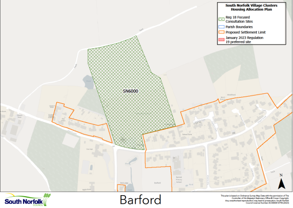
SN6000, Land north of Chapel Street, Barford
Proposed for: This new site was promoted through the January 2023 Regulation 19 publication for 25 dwellings, a relocated village hall and playing pitch, plus retention of the children's play area. Subsequent discussions have expanded this to approximately 30 dwellings plus additional community land. This makes a better use of the overall site. The total site area is 4.82 hectares.
Reasoned justification: The front of the site is currently the location of the existing Barford and Wramplingham Village Hall plus adjoining playing field. The Village Hall has become dated and in need of upgrading/repair. The Hall is leased from the current landowner, and has a relatively short time remaining on the lease, which could make it increasingly difficult to secure funding to sustain the necessary improvements.
As part of the January to March Regulation 19 process the site was submitted to the Council has a possible additional/alternative allocation, which would involve 25-30 dwellings on the site of the current village hall and playing field. The village hall is than relocated to the rear (north) of the site along with a new playing pitch. The recently refurbished play area at the entrance of the site would remain in situ.
The site is well located within the village in terms of townscape and relationship to existing services. The site does not present any issues relating to the natural or historic environment that cannot reasonably be mitigated. The site is well contained within the landscape and access already exists off Chapel Street. Development would need to include decommissioning of the existing structures on site.
The proposed location of the new village hall and playing field would make them slightly less accessible to the existing village, however this this needs to be balanced against the provision of better facilities for the longer term.
(62) QUESTION 3a: Do you agree with the allocation of SN6000, Land north of Chapel Street, Barford? Please explain your response.
(43) QUESTION 3b: If the site is allocated, do you think there are any specific requirements that should be set out in the allocation policy? Please tick the ‘comment’ button in your response and complete the associated text box.
SN0552REVC, Land at Watton Road, Barford
Proposed for: This site was previously classified as 'shortlisted' in the assessments supporting the January 2023 Regulation 19 publication. The site is now proposed for possible allocation in conjunction with VC BAR1 for up to 20 additional dwellings on an extra site of 0.73Ha.
Reasoned justification: The site is to the west of the current proposed Village Clusters Plan allocation, VC BAR1, on the west side of Back Lane. It was previously shortlisted, but not preferred, principally because safe pedestrian and cycle access (avoiding the B1108, Watton Road), would need to go through the VC BAR1 site. As such this site would need to be allocated as part of an extension to VC BAR1 to create a comprehensive scheme that addresses foot and cycle access.
The site is exposed to the open countryside to the west and would need to be designed and landscaped accordingly, to avoid Barford becoming much more prominent, when it is currently well contained in the landscape. The site would also be within the setting of the Grade II Listed Sayers Farmhouse to the south of Watton Road; it is acknowledged that the open, rural setting of the farmhouse will be impacted, and careful consideration will need to be given to the design, density and landscaping of development on the Watton Road frontage. As such, the 0.73ha site is currently proposed for up to 20 dwellings. However, SN0552 has been promoted to the Council in several configurations, and additional land could be available if necessary.