Village Clusters Housing Allocations Plan - Alternative Sites & Focused Changes (Reg. 18)
11. Wicklewood
Form and character
11.1. The main concentration of development has taken place along Wymondham Road, High Street, Hackford Road, Church Lane and Low Street. Further clusters of development have taken place at Milestone Lane and The Green. Individual farmsteads and dwellings are sparsely distributed through the rest of the parish. The core of the village has frontage development which encircles the nursery, mushroom farm and some agricultural land. A couple of small estate-type developments have grown up at All Saints Close and Hillside Crescent. Church Lane and Low St are located on the north-facing slope of a valley, and the dwellings here benefit from views of the surrounding countryside. The Grade II listed windmill is a distinctive feature on the eastern side of the High Street and dominates the skyline of this part of the village. Good road links exist to Wymondham and Hingham via the B1135 and B1108 respectively[IJ1].
Services and Community Facilities
11.2. There is a good range of facilities including a primary school, village hall, recreation field and pub. Wicklewood has a regular bus service to Norwich and Wymondham.
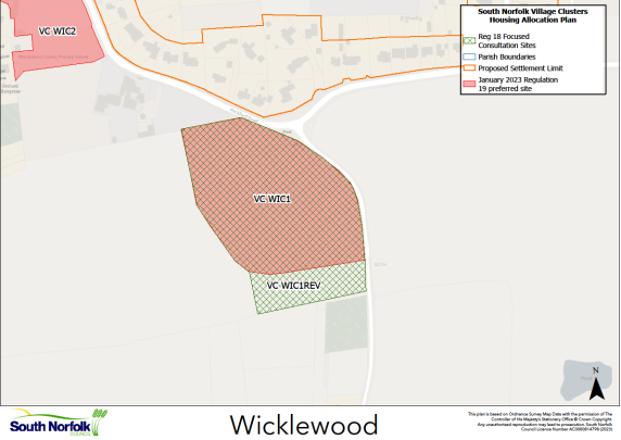
Settlement Limit
11.3. The Settlement Limit has been drawn to include the main built form of the settlement. There is a small break in the Settlement Limit where the central agricultural land is accessed (behind the mushroom farm on Church Lane).
11.4. The South Norfolk Place-making Guide advocates protection of the setting of local landmarks, such as Wicklewood windmill. There are surface water drainage issues in the village, and development must address this issue.
Site allocations and options
11.5. The January 2023 Regulation 19 document included three allocations in Wicklewood, one carried forward from the 2015 South Norfolk Local Plan, and two new allocations. These are:
- VC WIC1, Land to the south of Wicklewood Primary School. A new allocation of 2.50ha of land for up to 30 dwellings. It is proposed to retain this allocation but also consider it for potential extension.
- Policy VC WIC2: Land off Hackford Road. A new allocation of 0.89 ha of land for a minimum of 12 dwellings. It is proposed to retain this allocation unchanged.
- Policy VC WIC3: Land at Hackford Road. A carried forward 2015 Local Plan allocation of 0.7 hectares of land for approximately 6 dwellings. It is proposed to retain this allocation unchanged.
VC WIC1 REV, Land to the south of Wicklewood Primary School.
Proposed for: VC WIC1 was included in the January 2023 Regulation 19 document as a proposed allocation of up to 30 dwellings on 2.50ha of land. It is now proposed to extend the site to 2.97ha and increase the numbers to up to 40 dwellings as VC WIC1 REV.
Reasoned justification: Whilst creating VC WIC1 REV would take new allocations in Wicklewood to 52 dwellings, which is at the upper end for the Village Clusters Plan, the village does have the main basic services and good bus links to larger settlements. The Landscape and Visual Assessment (LVA) for the amended site boundary identified that the impact on the landscape will be broadly similar to that of VC WIC1 in the January 2023 Regulation 19 document and will in fact follow a more natural southern boundary. The increase in the site area and slight increase in the number of dwellings being proposed would not result in any material detrimental effects. Therefore, the Council proposes VC WIC1 REV is appropriate for the allocation of up to 40 dwellings. Should additional land be required within the allocation to address the landscape impacts through design, density, layout and landscaping, scope exists for this on land to the west.
The Regulation 19 Policy for VC WIC1 was written based on up to 30 dwellings on a smaller site area. As such, as well as changing the site area and dwelling number, the Policy for VC WIC1 REV may also need to be updated in other respects. The Regulation 19 wording can be seen here: https://southnorfolkandbroadland.oc2.uk/document/12/1228#d1785.