Village Clusters Housing Allocations Plan - Alternative Sites & Focused Changes (Reg. 18)
5. Ditchingham, Broome, Hedenham and Thwaite
Form and character
Ditchingham
5.1. Development within the parish has been concentrated along Loddon Road, Norwich Road, Station Road and Thwaite Road to form the established village of Ditchingham. Abutting the village to the east is the village of Broome. To the south of the parish at Ditchingham Dam is a small area of development which is contiguous with the built-up area of Bungay lying largely within the Broads Authority area and includes the large development on the former maltings sites. Development within the remainder of the parish comprises of individual dwellings and farmsteads.
5.2. The village has developed a nucleated settlement form largely as a result of substantial post-war development. The majority of this growth has taken the form of estate development between Thwaite Road and Loddon Road. An area of 1950s Tayler and Green housing at Windmill Green and Scudamore Place makes a significant contribution to the character of the village and is now a Conservation Area. The A143 runs across the south of the parish linking with Beccles and the A146 to the east and Harleston, the A140 and Diss to the west. The B1332 provides a link to Norwich, whilst local road and pedestrian facilities provide easy access to Bungay.
5.3. The village lies close to the Broads, and a large area of the southern part of the parish lies within the Broads Authority area.
Broome
5.4. Development within the parish has been along Yarmouth Road and Sun Road in a linear form with an isolated group of development at Broome Street. Elsewhere the parish displays a dispersed settlement pattern comprising individual dwellings and farmsteads. The south-western end of the village merges with development at Ditchingham so that there is no clear distinction between the two settlements at this point.
5.5. The village is set in attractive open countryside within the Waveney Valley. Broome Heath, a County Wildlife Site, lies to the north of Yarmouth Road and the undeveloped nature of this side of Yarmouth Road provides an open aspect which contributes significantly towards the rural character of the village. The A143, which by-passes the village, provides a link to Harleston and Diss to the south-west and Beccles and Great Yarmouth to the north-east, as well as Lowestoft via the A146. Local road and pedestrian links provide easy access to Bungay to the south, whilst the nearby B1332 provides a link to Norwich to the north.
5.6. Part of the parish lies within the Broads Authority area.
Services and Community Facilities
5.7. The cluster has a range of social, recreational and community facilities including a village hall, recreation field, shop, post office, pub, restaurant and primary school. The cluster is also home to several employment uses across different sectors. Ditchingham has a semi-regular bus service to Diss, Bungay, Beccles and Yarmouth and a limited service to Norwich. Broome has a semi-regular bus service to Diss, Bungay, Beccles and Yarmouth.
Settlement Limit
Ditchingham
5.8. The Settlement Limit has been drawn to include the main built form of the settlement, and to include the land to the north of Rider Haggard Way previously allocated in the 2015 Local Plan. An additional area of land promoted as part of the Plan process on land north-west of Lambert's Way has been assessed and incorporated into the updated Settlement Limit.
Broome
5.9. The Settlement Limit has been drawn to include the existing linear pattern of development in the settlement and to include the allocations made on the Old Yarmouth Road within the 2015 Local Plan.
Site allocations and options
5.10. The January 2023 Regulation 19 document included an allocation of 1.56ha of land for approximately 35 dwellings on Land at Thwaite Road and Tunney's Lane, Ditchingham, VC DIT1. It is proposed to retain this allocation.
5.11. This consultation considers extending VC DIT1 to create VC DIT1 REV, as well as considering an additional area of land at Broome for allocation:
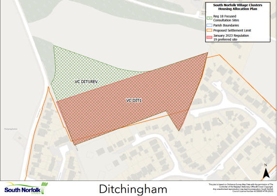
VC DIT1 REV, Land at Thwaite Road and Tunney's Lane, Ditchingham
Proposed for: VC DIT1 was included in the January 2023 Regulation 19 document for approximately 35 dwellings. It is proposed to increase the site area to 2.42ha, for an additional 10 dwellings, to create VC DIT1 REV for up to 45 dwellings.
Reasoned justification: Ditchingham is relatively well served in terms of services and facilities and Ditchingham Dam provides a direct route to a wider range of services and facilities in nearby Bungay. VC DIT1 was part of a larger site promoted to the Council. The larger site is well contained within the wider landscape and, as the site assessment which accompanied the Regulation 19 noted, could accommodate more dwellings. The main potential constraints to extending the site relate to highways and flood risk. Initial discussions with Norfolk County Council Highways indicate that the extended site can be accessed via the new development currently being completed off Rider Haggard Way. In terms of flood risk, this affects the eastern side of the site, as such the extension is proposed on the western (Thwaite Road) side of the site, see below.
Please note that the Council does not propose to change any other aspects of the Regulation 19 Policy for VC DIT1, other than the site area and number of dwellings. The original Policy wording can be seen here: https://southnorfolkandbroadland.oc2.uk/document/12/1228#d1355.
(7) QUESTION 7a: Do you agree with the proposed allocation of VC DIT1 REV, Land at Thwaite Road and Tunney's Lane, Ditchingham, for up to 45 dwellings on an area of on an area of 2.42ha? Please explain your response.
(9) QUESTION 7b: Do you think there are any specific requirements that should be added to the allocation policy to accommodate the extra 10 dwellings? Please tick the ‘comment’ button in your response and complete the associated text box.
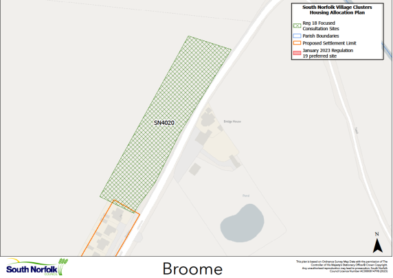
SN4020, Land west of Old Yarmouth Road, Broome
Proposed for: This site was previously classified as 'shortlisted' in the assessments supporting the January 2023 Regulation 19 publication. The site is now proposed as a possible allocation for at least 12 dwellings on an area of 0.76ha (please note this differs from the site assessment, as the originally promoted site now overlaps with a recently completed dwelling to the south).
Reasoned justification: The cluster is relatively well served in terms of services and facilities and Ditchingham Dam provides a direct route to a wider range of services and facilities in nearby Bungay. SN4020 is immediately north of the recently completed housing allocation from the 2015 Local Plan and development would need to continue this frontage layout. The site extends development further into the open countryside, and the Landscape and Visual Appraisal (LVA) in the Supporting Documents notes the need for careful design and landscaping to create a gateway to Broome, which could also help manage traffic speeds entering the village. The frontage footpath will need to be widened. There is an existing substantial dwelling on the opposite side of Yarmouth Road, which already creates a more enclosed feel to the east.