
South Norfolk Village Clusters Housing Allocations Plan (Reg. 18 Draft)
2. Alpington, Yelverton and Bergh Apton
Form and character
Alpington and Yelverton
The main built-up areas of Alpington and Yelverton form a contiguous settlement. Development is concentrated around Church Road and Wheel Road. There is also a significant area of development at Mill Road, Alpington. Small detached clusters of development exist to the west of the main built up area on Burgate Lane and to the south on Church Meadow Lane in Alpington, whilst a small number of individual dwellings and farmsteads are dispersed throughout the remainder of both parishes.
The settlement has developed as a ribbon form along Church Road and Wheel Road, though significant post-war estate scale development has taken place in the parish north of Wheel Road and west of Church Road, resulting in a more nucleated settlement form for this part of the settlement.
The settlement is set in generally flat open countryside, although in the south of Alpington there is a small area of attractive valley landscape. The village is characterised by good areas of tree and hedge planting especially along Church Road, which together with its setting and views of the surrounding countryside give it an attractive rural character.
The western limit of the village along Wheel Road / Burgate Lane is clearly defined by a significant tree belt on the north side of the road, which together with open fields on both sides of the road maintains the separation between the main village and the small cluster of dwellings to the west. The A146 is 1km (0.6 miles) to the north and provides a good link to Norwich and Loddon whilst the B1332 lies immediately to the west of the parish providing good links to services in Poringland and also to Norwich and Bungay.
Bergh Apton
Development within the parish is relatively small scale and in clusters along Cookes Road and The Street, and a larger concentration of development along Mill Road and Threadneedle Street that has created a linear settlement form characterised by one plot depth development. The main areas of settlement in the village retain a rural character with no estate scale development whilst the remainder of the parish consists of isolated dwellings and farmsteads. The local road network comprises 'C' class and unclassified roads. The A146 is to the north of the settlement and provides a good link to Norwich and Loddon.
Services and Community Facilities
The cluster has a range of social and community facilities including a village hall, shop, primary school and preschool. There is also a limited bus service.
Settlement Limit and Constraints
Alpington and Yelverton
The Settlement Limit for Alpington and Yelverton has been drawn to include the main built form of the settlement and is centred around development along Church Road and Wheel Road, and the small, estate-scale developments north of Wheel Road and west of Church Road. Along Mill Road there is an area of development within Alpington Parish which is covered by the Bergh Apton Settlement Limit. No alterations are proposed to the existing Settlement Limit other than through the specific preferred sites identified in the preferred and shortlisted sites section.
Bergh Apton
The Settlement Limit has been drawn to include three main areas of settlement within Bergh Apton. These are the linear development along Mill Road and Threadneedle Street; around the junction of Cookes Road and The Street which includes an allocation of seven dwellings and further south on The Street which includes an allocation of five dwellings made within the 2016 Site Allocations Plan. No alterations are proposed to the existing Settlement Limit.
The primary school within Alpington is noted as being full, but in catchment pupil numbers are understood to be lower with the school currently helping with overflow from Poringland.
(23) QUESTION 7: Do you agree with the extent of the Settlement Limit and any changes proposed? If not, please explain what further changes should be made.
Preferred and Shortlisted Sites
18 sites have been promoted for consideration, of which 4 were considered reasonable alternatives.
Preferred Sites
On the basis of the assessment undertaken the following site(s) have been identified as a preferred allocation:
|
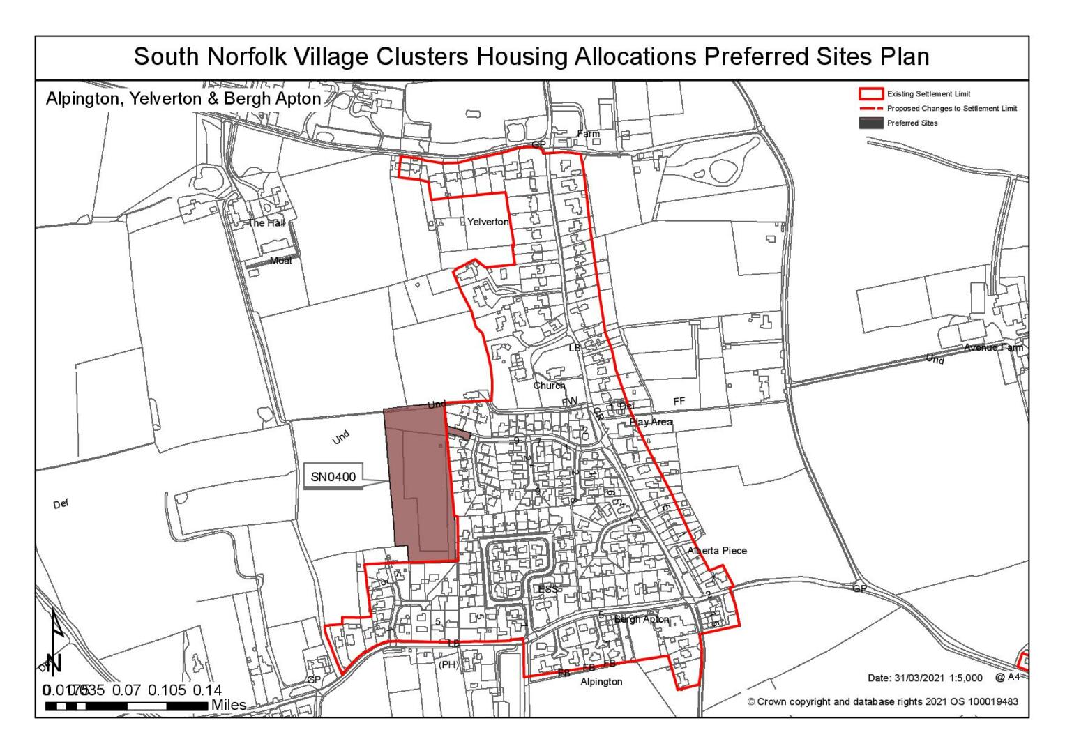
Site: SN0400 - Church Meadow, Alpington |
|
Preferred for up to 25 dwellings on a site of 1.87 hectares Reasoned justification: The site is well located in terms of access to local services/facilities, with footway links to those in the village. The site is visually well contained, with no overriding constraints. Suitable for allocation for up to 25 dwellings, reflecting the scale and density of Church Meadow and the constraints of the site shape. There is an opportunity to enhance the setting the veteran tree in the north east corner of the site. |
|
|
(63) QUESTION 8: Do you support or object to the allocation of the preferred site? Please add additional comments to explain your response and please specify which site(s) you are referring to. If the site is allocated do you think there are any specific requirements that should be set out in the allocation policy?
|
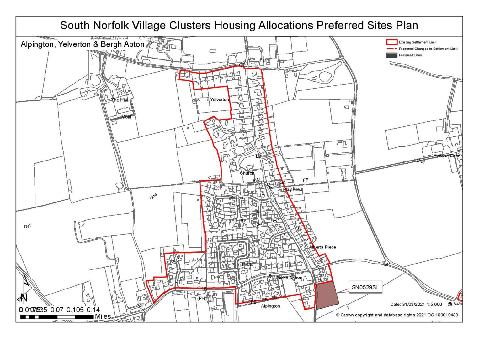
Site: SN0529SL - Nichols Road, Alpington |
|
Preferred for a Settlement Limit Extension on a site of 0.37 hectares. Reasoned justification: The site is adjacent to the existing Settlement Limit and within a reasonable distance of local services and facilities. However, development would need to respect the linear pattern of existing development on the western side of Nichols Road and should include appropriate landscaping, particularly to the eastern boundary. Development could potentially enhance the entrance to the village from the south. It has also been noted that a frontage access is preferred, rather than rear driveways like the adjoining scheme and that the footpath provided via the adjacent affordable housing development could be extended to serve this site. |
|
|
(26) QUESTION 9: Do you support or object to the proposed use of the site? Please explain your reasons
|
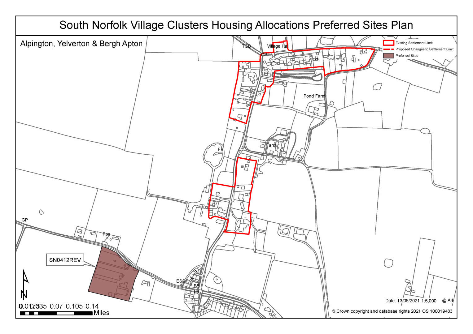
Site: SN0412REV - Former concrete works, Church Road, Bergh Apton |
|
Preferred for 25+ dwellings on a site of 1.7 hectares. Reasoned justification: This is a brownfield site. Whilst the site is not ideal in terms of highways access, the traffic generated by former uses (and potential lawful uses of the site) can be offset against the traffic from any redevelopment. Consideration needs to be given to the level of highways works that would be appropriate in this rural setting. Development of the site would be broadly consistent with the pattern of small clustered groups of dwellings that make up Bergh Apton, and preferable to further infilling between the clusters. The site itself has few constraints other than the clearance and clean-up costs related to the current buildings, hardstanding etc. Existing vegetation is non-native and redevelopment offers an opportunity to enhance the site. |
|
|
(26) QUESTION 10: Do you support or object to the allocation of the preferred site? Please add additional comments to explain your response and please specify which site(s) you are referring to. If the site is allocated do you think there are any specific requirements that should be set out in the allocation policy?
Shortlisted Sites
On the basis of the assessment undertaken the following site(s) have been shortlisted:
|
Site |
Location and reasons not preferred for allocation: |
|
SN0433 |
Land at Wheel Road, Alpington Shortlisted as a Reasonable Alternative for up to 25 dwellings on a site of 1 hectare. The site is reasonably located in terms of local services and facilities and has few on-site constraints. The main concerns with the site relate to the removal of the substantial frontage hedge (with trees) to facilitate the necessary highways improvements, across the whole site frontage from the Reeders Lane/Burgate Lane junction (which itself would require improvement) to the Wheel of Fortune. This would significantly change the character of the area and raise concerns in terms of wider landscape character. |
Rejected Sites
The following site(s) were promoted for development but have been rejected on the basis of information available at the time of assessment.
|
Site |
Location and Reasons for Rejection |
|
SN0435 |
Land at Burgate Lane (Glebe Field), Alpington Whilst there an existing site access via Burgate Lane, there are significant trees on the site frontage that would prevent achieving a satisfactory access with sufficient visibility splays. These trees also provide a significant feature in the street scene, where their removal would cause harm to the landscape. Whilst the site is in close proximity to some local services and facilities, there are no footways along this part of Burgate Lane to the main part of the village, where there is also a lack of continuous footways. The adjoining properties are very low density and significantly set back from the road frontage, therefore development of the site would not be in keeping with the form and character of the neighbouring development. |
|
SN4030 |
Land at Mill Farm, Mill Road, Bergh Apton Mill Road is separate from the main settlement and the surrounding highway network is substandard with no safe walking route to the school and poor access at each junction end. The site is behind Mill Farm and does not relate well to the existing linear pattern of frontage development, as it would extend development further south. In addition, there is insufficient frontage to provide adequate access into this site. |
|
SN2022 |
The Dell, Bergh Apton The site isremote location away from any settlement and services. The highway network is inadequate to support development in this location and there is no safe walking route to the school. There would be a loss of trees and habitat to the detriment of the surrounding landscape and environment. |
|
SN2023 |
Land south of Loddon Road and east Bergh Apton house, Bergh Apton The site is remote location away from any settlement and services. The highway network is inadequate to support development in this location and there is no safe walking route to the school. There would be a loss of trees and habitat to the detriment of the surrounding landscape and environment. |
|
SN0434 |
Bergh Apton Road, rear of Alberta Piece, Alpington Whilst the site is adjacent to the existing Settlement Limit and within a reasonable distance of local services and facilities, actual accessibility is much more limited due to the constraints of the local highway network. The site also provides an attractive rural setting where the site is very visible when approaching from Bergh Apton, where the removal of hedgerows to provide site access would cause harm to the wider landscape. Development of the site would represent an out of character breakout into the open countryside. Few other constraints have been identified. |
|
SN1012 |
Mill Field, Mill Road Mill Road is separate from the main settlement and the surrounding highway network is substandard with no safe walking route to the school and poor access at each junction end. The site extends behind the existing linear pattern of frontage development and would encroach further north which is out of character. In addition, there are significant existing trees and hedging along the frontage which would be lost with a negative impact on the landscape character |
|
SN2006 |
South of Loddon Road (A146) and Gull Lane, Yelverton Development of the site would be a significant extension into the countryside that would not reflect the exiting form of the settlement on this side of Yelverton. Highways have also raised issues with the proposed access from the A146 'Corridor of Movement'. There is no possibility of creating suitable access to the site in the vicinity of the existing Gull Lane junction and almost opposite the Gull Inn. The site is also heavily constrained by flood risk where half of the site, including the proposed access point, is Flood Zone 3a and at a higher level of surface water flood. There is also potential impact on the CWS immediately to the south west. |
|
SN2015 |
Town Farm, Church Road, Bergh Apton The site has a poor relationship to the main areas of settlement within Bergh Apton. Whilst the site is part of a smaller group of dwellings along Church Road , it is separated from the main village (and the local facilities) where there is no current Settlement Limit in this location. The site also provides an attractive rural setting where development would be detrimental to the existing rural form and character. Highway constraints have also been identified, especially regarding the unsuitable local road network. |
|
SN0203 |
Land to the south of Church Road, Bergh Apton Whilst the site would broadly fit with the 'clustered' nature of Bergh Apton, it is adjacent to a significant grouping of listed Tayler and Green properties. Church Road itself is narrow, with no footways. Whilst the nearby preferred brownfield site can offset the traffic generated by new dwellings against the previous use of the site, the same cannot be said of a greenfield site. Loss of the frontage hedge would also erode the character of the area, and the site would be further constrained by the need to protect the mature oak trees on the boundary of the property to the west. |
|
SN0210 |
Church Wood, Welbeck Road, Bergh Apton Although the site is opposite a County Council recycling centre, it is not considered that further development in this location would be acceptable. The site is remote from services/facilities in Bergh Apton and other settlements, with a poor highways network the already supports the recycling centre traffic. The site forms and attractive, partially wooded, section of the Well Beck/Chet Valley, bisected by a public right of way. The site is also immediately adjacent to a County Wildlife Site and the Grade II* Listed St Peter & St Paul's Church. |
|
SN0433REV |
Land at Wheel Road, Alpington This is a larger area of land extending to 3.3 hectares of which site SN0433 is part. The site is reasonably located in terms of local services and facilities and has few on-site constraints. The main concerns with the site relate to the removal of the substantial frontage hedge (with tress) to facilitate the necessary highways improvements, across the whole site frontage from the Reeders Lane/Burgate Lane junction (which itself would require improvement) to the Wheel of Fortune. This would significantly change the character of the area and raise concerns in terms of wider landscape character. Would also unacceptably impact on the rural setting of the listed Stacey Cottage to the south of the site. |
|
SN0533 |
Land east of The Street, Bergh Apton As with other parts of Bergh Apton, the wider highways network is a concern, although access to this site should be achievable from The Street. However, this access would be likely to require the removal of a significant roadside hedge, the loss of which in itself would be a concern, but which would also increase the impact of any development on the settlement pattern (emphasising the closing up of the currently dispersed pattern) and also on the nearby listed cottage. |
|
SN0122SL |
Land to the north of Cooke's Road, Bergh Apton The site isseparate from the main part of the settlement and the surrounding highway network is substandard with no safe walking route to the school. A 2019 appeal decision concluded that two dwellings on this site would have an 'unacceptably harmful effect on highway safety'. Whilst it is adjacent to the settlement limit there would be an impact on the landscape as it would extend into countryside to the north of Cooke's Road and the character is of limited development; the 2019 appeal decision highlighted this site would 'cause material harm to the area's open and rural appearance'. It would also have an impact on the nearby heritage assets including the historic parkland setting of Bergh Apton Manor, and nearby listed properties. |
|
SN2117 |
Land adjacent to the village hall, Bergh Apton The site isseparate from the main part of the settlement where the surrounding highway network is substandard with no safe walking route to the school. Whilst it is adjacent to the settlement limit there would be an impact on the landscape as it would extend into countryside to the north of Cooke's Road and the character is open with limited development. An appeal decision for two dwellings on the adjacent site would 'cause material harm to the area's open and rural appearance'. It would also have an impact on the nearby heritage assets including the historic parkland setting of Bergh Apton Manor, and nearby listed properties. |
(31) QUESTION 11: Do you think that any of the shortlisted or rejected sites should be allocated instead of, or in addition to, the preferred site? Please explain your response and please specify which site(s) you are referring to.
(16) QUESTION 12: Do you think that any of the shortlisted sites should be considered unreasonable? Please explain your response and please specify which site(s) you are referring to.
To find out more about the Village Clusters Housing Allocations Plan, please visit our Virtual Exhibition.