
South Norfolk Village Clusters Housing Allocations Plan (Reg. 18 Draft)
8. Brooke, Kirstead and Howe
Form and character
Brooke
The village is situated on the B1332 Norwich – Bungay Road with development traditionally located in a linear form running eastwards and westwards from the Norwich Road (B1332) along The Street and High Green. Some modern estate development has occurred off both these roads.
The village is characterised by a mixture of dwellings, especially on The Street and High Green where there are many historic buildings. These combine with trees, hedges, water features and undeveloped spaces to create an attractive area which is encompassed by a conservation area. There is a small but important area of open space at the southern end of Brecon Road. The area immediately to the south of the village is well wooded which creates a visual shield for the village. Elsewhere within the parish development is widely dispersed comprising individual dwellings and farmsteads, although Brooke Industrial Park has been developed in recent years to the north of the village on the B1332. This road provides relatively good access to Norwich some 12km to the north and Bungay to the south. The remainder of the local road network comprises a mixture of 'C' class and unclassified roads.
Kirstead
Kirstead is a sparsely populated parish. It comprises individual dwellings and farms dispersed throughout, together with a concentration of linear development at Kirstead Green and Green Man Lane, set in attractive open countryside.
Howe
Howe is a sparsely populated parish. The development in the parish displays a scattered form and has been concentrated along Howe Green with a small number of individual farmhouses dispersed throughout the remainder of the parish.
Services and Community Facilities
The cluster has a range of social, community and recreational facilities including a pub, farm shop, primary school, a village hall and a limited bus service. There are also employment opportunities at the industrial park.
Settlement Limit and Constraints
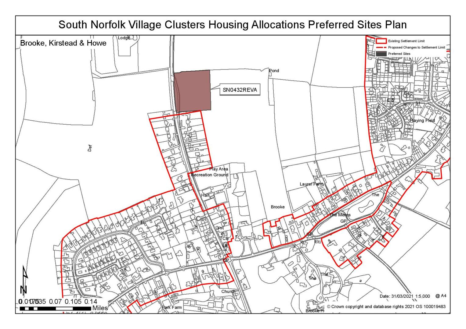
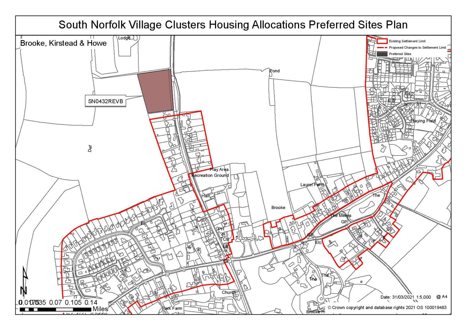
The Settlement Limit for Brooke is in three parts. Within the main settlement itself, the boundary is divided into a western section around development along High Green and Norwich Road and an eastern section encompassing development along The Street. Parts of the centre of the village around the Meres and the Conservation Area around Brooke House have been specifically excluded. The third section of Settlement Limit is to the north of the main settlement and defines the Brooke Industrial Park employment area. No alterations are proposed to the existing Settlement Limit.
(26) QUESTION 33: Do you agree with the extent of the Settlement Limit and any changes proposed? If not, please explain what further changes should be made.
Preferred and Shortlisted Sites
15 sites have been promoted for consideration, of which 2 have been identified as preferred allocations and 1 further site shortlisted. One of the sites promoted for consideration (SN0077SL) obtained planning permission (District Reference: 2018/0868) in September 2018 (SN0077SL).
Preferred Sites
On the basis of the assessment undertaken the following site(s) have been identified as a preferred allocation:
|
Site: SN0432REVA, East of Norwich Road |
|
Preferred for up to 25 dwellings on a site of 1 hectare. Reasoned justification: The site is well located and relatively unconstrained, however it is quite open in the landscape and development in depth to achieve a reasonable density/volume of dwellings would require careful design. There is a need to consider the highways requirements in relation to potential development on the west of Norwich Road in combination with this site. |
|
|
(56) QUESTION 34: Do you support or object to the allocation of the preferred site? Please add additional comments to explain your response and please specify which site(s) you are referring to. If the site is allocated do you think there are any specific requirements that should be set out in the allocation policy?
|
Site: SN0432REVB, West of Norwich Road |
|
Preferred for up to 25 dwellings on a site of 1.2 hectares. Reasoned justification: The site is well located and relatively unconstrained. The site fills a gap between the existing settlement and the grounds of Brooke Lodge; however, it is open to wider countryside to the rear (west) and development in depth to achieve a reasonable density/volume of dwellings would require careful design. There is a need to consider the highways requirements in relation to potential development on the east of Norwich Road in combination with this site. |
|
|
(53) QUESTION 35: Do you support or object to the allocation of the preferred site? Please add additional comments to explain your response and please specify which site(s) you are referring to. If the site is allocated do you think there are any specific requirements that should be set out in the allocation policy?
Shortlisted Sites
On the basis of the assessment undertaken the following site(s) have been shortlisted:
|
Site |
Location and Reasons not preferred for allocation: |
|
SN2119 |
North of High Green/West of Astley Cooper Place. Shortlisted for up to 25 dwellings on a site of 1 hectare. The site is within a reasonable distance of the services and facilities in Brooke. However, there concerns related to: the suitability of High Green in this location and the ability to achieve a safe access; the ability to achieve a footway to link with existing provision and the impact this could have on the Conservation Area; and, the impact on the setting of the Listed dwelling at 66 High Green. The site itself includes areas of surface water flood risk and extensive vegetation. However, adjacent land is in the same ownership which could offer opportunities to revise the site area to minimise impacts in respect of the above constraints. The acceptability/deliverability of this site is subject to demonstrating access via Astley Copper Place. |
Rejected Sites
The following site(s) were promoted for development but have been rejected on the basis of information available at the time of assessment.
|
Site |
Location and Reasons for Rejection |
|
SN0020SL |
Rear of 43 High Green, Brooke Whilst the site is well located in terms of access to services and facilities, it falls wholly within the Conservation Area and includes a number of trees, which if lost could affect that character of the area. Trees, plus a potential ransom strip could prevent access from The Mallows Walk, although alternative access via the garden of 43 High Green should be possible. |
|
SN0490 |
South east of Mereside, Brooke Although centrally located within Brooke, with good access to local services and facilities, the main issues centre around the heritage/townscape/landscape impacts of a site within the Conservation Area, which extends over this site to protect the rural setting of the settlement, and which is visible from Hunstead Lane and the adjoining PRoW. A number of issues also remained outstanding at the time the appeal for 17 dwellings was dismissed in 2015, including those related to ecology and surface water drainage. |
|
SN0579SL |
North of Waldor Cottage, High Green The site is promoted for 'starter homes' in a location with is highly unlikely to encourage walking and cycling for everyday journeys on an unlit, 60mph road with no footways. The site has a substantial frontage hedge and extensive planting, the removal of which would significantly change the character of the area, particularly in the context of the Ancient Woodland to the rear of the site, the nearby listed building and when existing Brooke along High Green. The ditch and associated surface water flood risk is also concern. |
|
SN0583 |
Laurel Farm, north of The Street There are a number of concerns with this site. There is a lack of clear access arrangements. There is concern over the impact on the rural setting of the Conservation Area and nearby listed buildings (particularly those on the Laurels Farm access and visible from Brooke Footpath 3, which runs through the site). The site does not relate well to the built form of the village. There is also concern about the landscape impact of a detached development in a relatively unscreened site. |
|
SN0584 |
West of Burgess Way, Brooke The site is reasonably well connect to the services and facilities in Brooke, with no obvious features on the site itself. However, the scale and form of development would be limited by the shape of the site and the adjoining bungalow development on Burgess Way. The submission indicates access rights need to be acquired and this is based on the site being put forward for 25 dwellings, the feasibility of which has yet to be demonstrated. Therefore there are questions over the achievability of the site. In addition, it is considered that the impacts on the rural setting of the Conservation Area, and a number of listed buildings within it (particularly 57 The Street) would make this site unacceptable. |
|
SN2018 |
East of Norwich Road Whilst the site is well located and relatively unconstrained, it is too large for the purposes of the VCHAP, with no overriding benefits to justify a larger site. A smaller part of the site is considered as SN0432REVA. |
|
SN2122 |
East of Wood Farm The site would be out of keeping without development of the adjoining site (SN2119) and in combination they are too large for the purposes of the VCHAP. Issues regarding the integrating a very exposed/open site with development in this part of the village would remain, as would the need take account of the agricultural/commercial buildings on the western boundary, addressing the highways concerns and the need to provide a footway link to local services and facilities. |
|
SN2174 |
Land east of Kirstead Green/south of St Christopher Close The site itself is constrained primarily by the pumping station on site and the presence of surface water flood risk, otherwise it is a relatively well contained site. The loss of frontage hedgerows and trees would be a concern. Whilst at some distance from services and facilities, and therefore unlikely to encourage walking/cycling, it does have good access to the Bungay/Norwich bus service. Kirstead has not had a Settlement Limit since the 1994 Local Plan and would require one to be reinstated for this site to be included. |
|
SN4004 |
West of Kirstead Green The site itself is constrained primarily by the presence of surface water flood risk and the ribbon form of development that would result from the site's development and which would extend beyond the current edge of the settlement. Otherwise it is a relatively well contained site. The loss of frontage hedgerow would be a concern, and the vegetation to the B1332 boundary would need to be retained for visual containment and amenity. Whilst at some distance from services and facilities, and therefore unlikely to encourage walking/cycling, it does have good access to the Bungay/Norwich bus service. Kirstead has not had a Settlement Limit since the 1994 Local Plan and would require one to be reinstated for this site to be included. |
|
SN4047 |
East of Old Hall Gardens/Brooke Flock Farm, Brooke Although within a reasonable distance of most village services/facilities and with few constraints as an arable greenfield site, there are a number of concerns particularly regarding achieving suitable access, heritage impact on the Conservation Area and nearby listed buildings, landscape/townscape impact and ecology re the adjoining TPO'ed woodland and wider wooded landscape. |
|
SN4065SL |
Adj Oaklands, Honey Pot Lane, Brooke |
(34) QUESTION 36: Do you think that any of the shortlisted or rejected sites should be allocated instead of, or in addition to, the preferred site? Please add additional comments to explain your response and please specify which site(s) you are referring to.
(31) QUESTION 37: Do you think that any of the shortlisted sites should be rejected? Please add additional comments to explain your response and please specify which site(s) you are referring to.
To find out more about the Village Clusters Housing Allocations Plan, please visit our Virtual Exhibition.