
South Norfolk Village Clusters Housing Allocations Plan (Reg. 18 Draft)
45. Wicklewood
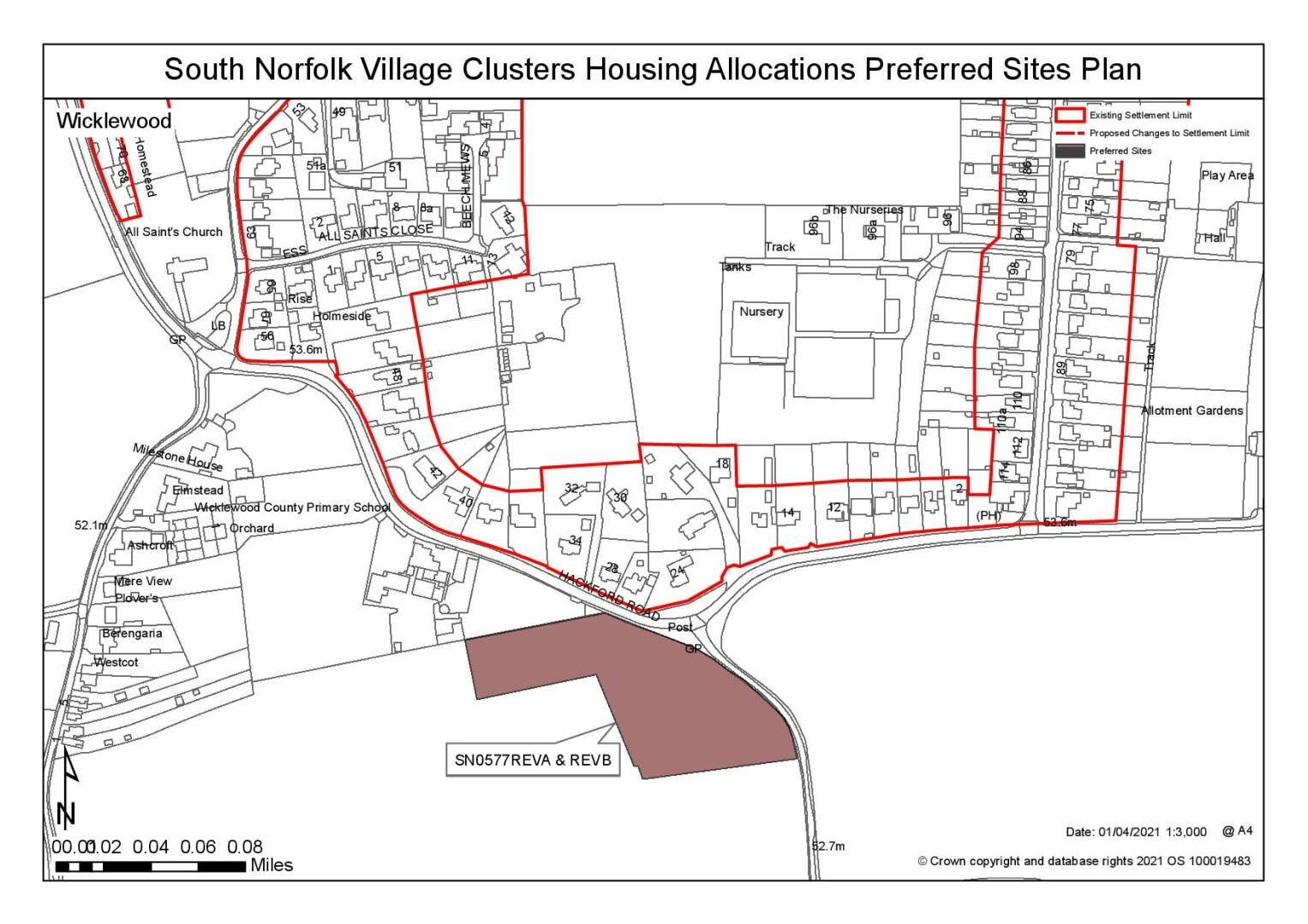
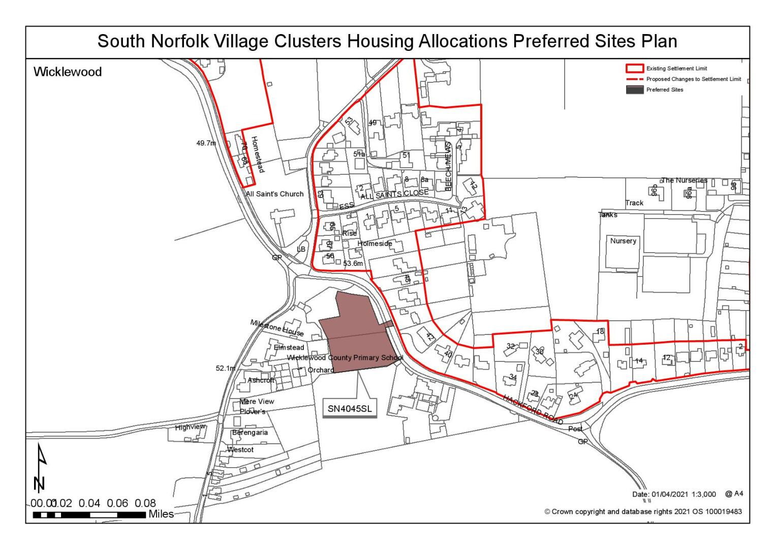
Form and Character
The main concentration of development has taken place along Wymondham Road, High Street, Hackford Road, Church Lane and Low Street. Further clusters of development have taken place at Milestone Lane and The Green. Individual farmsteads and dwellings are sparsely distributed through the rest of the parish. The core of the village has frontage development formed into a doughnut shape, with local employment sites of the nursery and mushroom farm, along with some agricultural land, in the centre. A couple of small estate-type developments have grown up at All Saints Close and Hillside Crescent. Church Lane and Low St are located on the north-facing slope of a valley, and the dwellings here and on Hackford Road and Wymondham Road benefit from extensive views of the surrounding countryside. The Grade II listed windmill is a distinctive feature on the eastern side of the High Street and dominates the skyline of this part of the village. Good road links exist to Wymondham and Hingham via the B1135 and B1108 respectively.
Services and Community Facilities
There is a good range of facilities including a preschool, primary school, village hall and pub. The village has recreation areas, a regular bus service and has mains sewers discharging to the Wymondham sewage treatment works.
Settlement Limit and Constraints
The Settlement Limit has been drawn to include the main built form of the settlement and include the allocated land. There is a small break in the Settlement Limit where the central agricultural land is accessed (behind the mushroom farm on Church Lane).
The South Norfolk Place-making Guide advocates protection of the setting of local landmarks, such as Wicklewood windmill. New development should enhance the setting of the windmill, which is currently shielded by leylandii trees at the roadside. There are surface water drainage issues in the village, and development must address this issue. No alterations are proposed to the existing Settlement Limit.
It is noted that the primary school is operating near or at capacity. This is likely to be due to its role supporting growth in the Wymondham/Hethersett areas. Further exploration will be needed to ensure primary school needs can be met.
(24) QUESTION 155: Do you agree with the extent of the Settlement Limit and any changes proposed? If not, please explain what further changes should be made.
Preferred and Shortlisted Sites
11 sites have been promoted for consideration, of which 2 were identified as preferred allocation sites and 1 was shortlisted.
Preferred Sites
On the basis of the assessment undertaken the following site(s) have been identified as a preferred allocation:
|
Site: SN0577REVA and REVB, Land to the south of Wicklewood Primary School |
|
Preferred for up to 30 dwellings on a site of 1.2 hectares Reasoned justification: The site is in a prominent location within the local landscape however with careful design it could enhance the gateway to the village. A Design Brief may be required for this site ensure appropriate design. The site is well connected to the settlement and highways matters could be reasonably addressed through the development of the site. Development of the site has potential to provide scope for expansion of the school. |
|
|
(44) QUESTION 156: Do you support or object to the allocation of the preferred site? Please add additional comments to explain your response and please specify which site(s) you are referring to. If the site is allocated do you think there are any specific requirements that should be set out in the allocation policy?
|
Site: SN4045SL, Land south of Hackford Road |
|
Preferred for up to 12 dwellings on a site of 0.49 hectares Reasoned justification: The site relates well to the existing form of development and could accommodate a small allocation. Highways access to the site is likely to be acceptable although it may result in the loss of the frontage hedgerow. The site is within the setting of a listed building but due to the existing pattern of development is relatively well contained and with appropriate mitigation measures would not have a significant impact on the setting of the Church. Mitigation could include design measures to the north of the site to retain views of the Church from Hackford Road. |
|
|
(40) QUESTION 157: Do you support or object to the allocation of the preferred site? Please add additional comments to explain your response and please specify which site(s) you are referring to. If the site is allocated do you think there are any specific requirements that should be set out in the allocation policy?
Shortlisted Sites
On the basis of the assessment undertaken the following site(s) have been shortlisted:
|
Site |
Location and Reasons not preferred for allocation: |
|
SN4064 |
Wicklewood Nurseries, High Street, Wicklewood Shortlisted for up to 15 dwellings on a site of 0.6 hectares. The site is subject to clarification being obtained about the future use of the remainder of the nurseries site and the possible loss of employment land. Access to the site is constrained which is likely to limit development. |
Rejected Sites
The following site(s) were promoted for development but have been rejected on the basis of information available at the time of assessment.
|
Site |
Location and Reasons for Rejection |
|
SN0232REV |
Land to the south of Low Street, Wicklewood Significant highways concerns have been identified and it is not considered that it would be possible to overcome these issues. Development of this site would also have an impact on the form and character of this part of the settlement and would also have an impact on the setting of both designated and non-designated heritage assets. |
|
SN0249SL |
Land adjacent to former workhouse / hospital, Green Lane, Wicklewood The site includes a large number of TPO trees within the site boundaries which would significantly reduce the developable areas. The site is also detached from the main settlement and is therefore not considered to be an appropriate site for a settlement limit extension. Development of this site would also have an impact on the setting of the former workhouse to the east. Highways concerns have also been identified. |
|
SN0535 |
Land to the south of Church Lane, Wicklewood Although the site could be reduced in size to meet the aspirations of the VCHAP it is considered to be unreasonable as an allocation as significant access constraints preclude development of the site. Access would need to be obtained via a narrow access driveway between two dwellings. |
|
SN0577REVB |
Land to the south of Wicklewood Primary School The proposal incorporates residential development as well as a suite of significant other benefits including additional car parking facilities for the school, open space and educational facilities. No evidence has been provided to confirm that these facilities would be required at this time or in this location. Access to the site would be achievable and the site is well connected, it is however very prominent within the landscape. It is considered that an alternative scheme on a smaller parcel of land would be the most appropriate option in this location (SN0577REVA). |
|
SN1036 |
Land to the rear of Windfalls, Milestone Lane, Wicklewood The site has been considered as unreasonable as both an allocation and a settlement limit extension. The site relates poorly to the main settlement and significant access and connectivity constraints associated with its remote location have been identified. |
|
SN2179 |
Land east of High Street, Wicklewood The site is excessive in size and would not meet the objectives of the VCHAP although the identified flood risks would restrict the developable area of the site. Nonetheless, development of the scale proposed would have an intrusive impact on the local landscape and townscape that could not be easily mitigated. Significant areas of the site also lie within Flood Zones 2 and 3. |
|
SN2179REVA |
Land east of High Street, Wicklewood The site has a significant area of identified flood risk that would impact upon the developable area of the site. Landscape and townscape impacts could be mitigated however the onsite areas of flood risk and the identified highways concerns, including poor connectivity of the site, are constraints that it is not considered to be possible to reasonably address. |
|
SN4001 |
Land west of Milestone Lane, Wicklewood Development of this site would have a significant impact on the landscape character, as well as the setting of a Grade I listed Church. The topography of the site within the open landscape would result in development being visible in long views back towards the settlement and it would not be possible to provide reasonable mitigation to address this. Highways constraints could be addressed. |
(17) QUESTION 158: Do you think that any of the shortlisted or rejected sites should be allocated instead of, or in addition to, the preferred site?
(11) QUESTION 159: Do you think that any of the shortlisted sites should be considered unreasonable? Please explain your reasons.
To find out more about the Village Clusters Housing Allocations Plan, please visit our Virtual Exhibition.