
South Norfolk Village Clusters Housing Allocations Plan (Reg. 18 Draft)
34. Spooner Row and Suton
Form and character
The village has developed as four significant settlement groupings, with the Norwich to Ely railway line and agricultural land separating the groups. The large open spaces between these settlement groups contribute to the character of the village. To the north-east, across the A11, is Suton which is a small hamlet.
Services and Community Facilities
Spooner Row has a station on the Norwich to Ely railway line. It has a minor road connection to the A11 providing access to Attleborough, Wymondham and Norwich. The village hall, rail halt and primary school are in the School Lane/Station Road cluster. There are also preschool facilities in the village.
Settlement Limit and Constraints
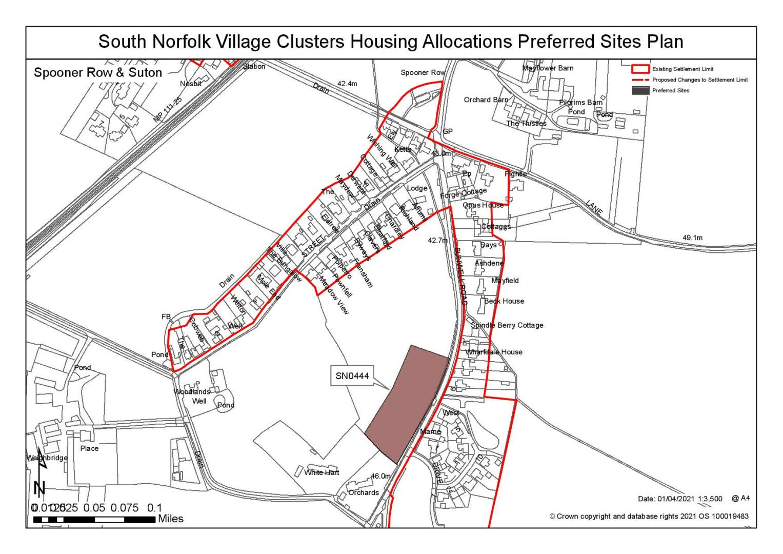
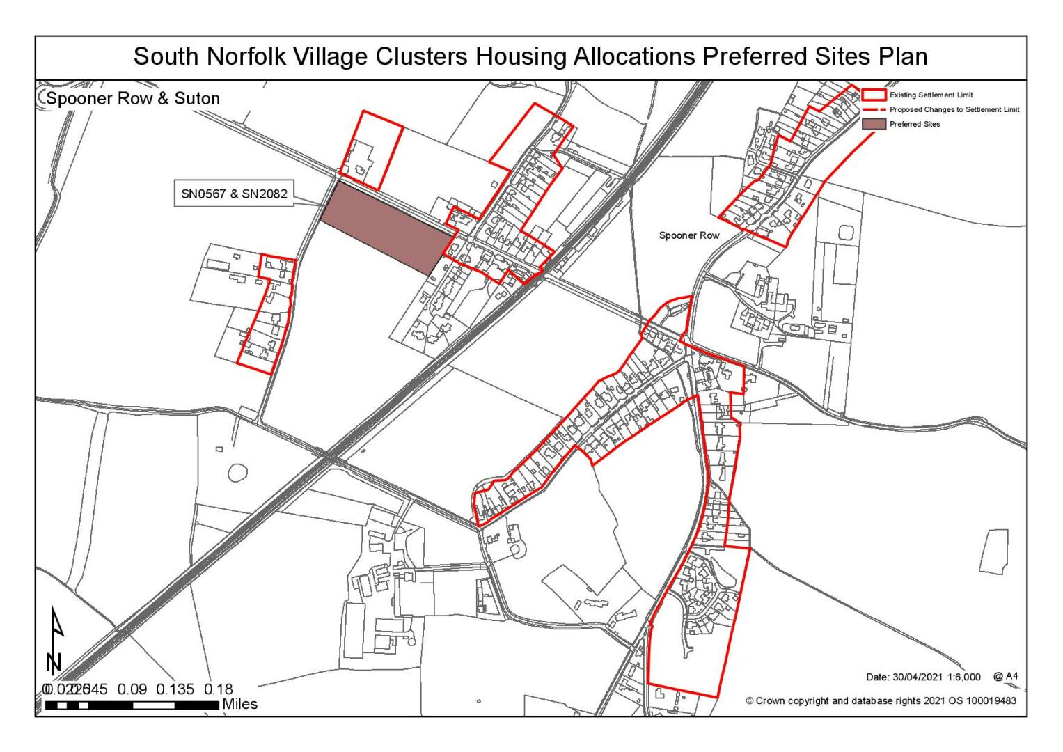
The Settlement Limit has been drawn to include the main built form of the settlement but excludes the school playing field. No alterations are proposed to the existing Settlement Limit.
(2) QUESTION 119: Do you agree with the extent of the Settlement Limit and any changes proposed? If not, please explain what further changes should be made.
Preferred and Shortlisted Sites
15 sites have been promoted for consideration, of which 3 were identified as preferred allocations. No further sites were shortlisted.
Preferred Allocations
On the basis of the assessment undertaken the following site(s) have been identified as a preferred allocations:
|
Site: SN0444, Land west of Bunwell Road, Spooner Row |
|
Preferred for up to 15 dwellings on a site of 0.7 hectares. Reasoned justification: Option for allocation subject to a reduction in the overall site area to meet to the objectives of the VCHAP and to avoid the identified areas of flood zones 2 and 3a within the site. It is also been raised roadside ditches within the site help manage surface water across a wider area. Development would be subject to confirmation of suitability from the Lead Local Flood Authority. Development would be to the south of the site and would complement the new development on the opposite side of Bunwell Road and relates suitably to the existing village. Development to the south of the site would result in the loss of hedgerow along the road frontage in order to create a suitable access into the site. |
|
|
(7) QUESTION 120: Do you support or object to the allocation of the preferred site? Please add additional comments to explain your response and please specify which site(s) you are referring to. If the site is allocated do you think there are any specific requirements that should be set out in the allocation policy?
|
Site: SN0567, Land south of Station Road and west of Queensland, Spooner Row & (Part) SN2082, Land south of Station Road and east of Top Common |
|
Preferred for up to 25 dwellings on a site of approximately 1 hectare Reasoned justification: This proposed allocation comprises two adjacent sites, Site SN0567 and SN2082. Site SN0567 lies adjacent to Station Road at the front of the site and has previously had the benefit of planning permission. Site SN2082 lies behind SN0567. As promoted SN2082 is a much larger site and only the element nearest SN0567 is preferred for development. This reduces landscape impacts and bring the overall scale of development in line with the aims of the plan. Access to the site would need to be achieved via Station Road, this would result in the loss of frontage hedgerow, and the possible need to remove off-site trees. However, the site has a good relationship with the existing settlement and a linear form of development along the frontage of the site would complement the existing pattern of development. There would be a landscape impact resulting from the development that would need to be addressed by way of an appropriate landscaping scheme. |
|
|

(9) QUESTION 121: Do you support or object to the allocation of the preferred site? Please add additional comments to explain your response and please specify which site(s) you are referring to. If the site is allocated do you think there are any specific requirements that should be set out in the allocation policy?
Rejected Sites
The following site(s) were promoted for development but have been considered to be unreasonable alternatives on the basis of information available at the time of assessment.
|
Site |
Location and Reasons for Rejection |
|
SN0227 |
Land at Eleven Mile Lane, Suton A number of constraints have been identified, including highways concerns about creating an appropriate access into the site as well as the wider highway network. An estate form of development is also considered to be an inappropriate form and scale of development in this rural settlement which is characterised by a small scale mainly linear pattern of development. |
|
SN0404 |
Land to the south-east of Chapel Road, Spooner Row (rear of allocation SPO1) Development of the site would constitute backland development and would have an adverse impact on the form and character of the existing linear pattern of development. It would also have a detrimental impact on the approach to the village from the north. Access would be required through existing allocation and may require the loss of additional hedgerow. |
|
SN0445 |
Land south of Station Road, Spooner Row As promoted the site is excessive in scale however it could be reduced in size. Notwithstanding this, development of the most logical areas of the site would be constrained by significant areas of flood zone 2 and 3a. Significant offsite highway works have also been identified as necessary to make this site acceptable in highway terms. There would also be a detrimental landscape impact associated with the development of this site. |
|
SN0446 |
Land north of Guilers Lane and east of Chapel Road, Spooner Row Development of the site would impact on both designated and non-designated heritage assets and would also have a detrimental impact on the form and character of this part of the settlement. There would also be a likely landscape impact resulting from the loss of hedgerow and mature trees. A smaller area of development is not considered to address these concerns adequately due to the prominent location of the site. |
|
SN0447 |
Land west of Chapel Road, Spooner Row Due to the identified areas of flood risk within the site, development would be concentrated to the north of the site, closest to the rear of existing properties along Chapel Road. This would lessen the erosion of the gap between the two distinct areas of the settlement but would impact on identified heritage assets and result in the loss of hedgerow and mature trees along Chapel Road. Off-site highway works would also be required. |
|
SN0448 |
Land west of School Lane and north of the school School Lane has been identified as being constrained in highways terms and is not considered to be appropriate for further development (following development of the existing allocation site SCO2). Although the site relates reasonably well to the settlement, development of the scale proposed and/ or of an estate form is not considered to be compatible in either form or character with the existing linear pattern of development. |
|
SN0568 |
Land to south of Station Road and west of Top Common, Spooner Row Due to identified on-site constraints development would be to the south of the site and would appear detached from the main body of the settlement when viewed from Station Road. Development of the site would have an adverse landscape impact and would also likely result in the loss of frontage hedgerow. A suite of off-site highways works have been identified and it would need to be confirmed that access into the site could be achieved. |
|
SN0569 |
Land west of Bunwell Road and south of Queens Street, Spooner Row Development of the site would erode the rural character that is in evidence, particularly on the approach to the settlement along Bunwell Road. Furthermore, the adjacent listed building faces into the site and development of the site would have a detrimental impact on its setting. Highways have also raised significant concerns about the ability to achieve appropriate visibility splays if developing this site. |
|
SN2101 |
Land to the North and East of Spooner Row. Site SN2101 was promoted as a 'garden village' site in the settlement of Spooner Row. Due to its strategic scale the site is considered to be inconsistent with emerging Policy 7.4 (Village clusters) of the Greater Norwich Local Plan and has been rejected on this basis. As the proposal falls outside the scope of the Village Clusters Housing Allocations Plan, the garden village proposal has not been subject to a detailed assessment within this plan. However, the site was also promoted as a number of smaller parcels and these sites have been considered on their own merits, in accordance with the VCHAP objectives. The individual site references are: SN0444, SN0445, SN0446, SN0447 and SN0448. |
|
SN2157 |
Land at Great Expectations, London Road, Suton The site is excessive in size however it could be reduced in size to meet the objectives of the VCHAP however it is remote from the main centres of development with poor connectivity and it would have an adverse landscape impact. The site currently has a number of commercial tenants as well as a leisure school which may be affected by residential development on the site. |
|
SN2181 |
Land east of School Lane, Spooner Row Significant highways constraints have been identified, including concerns about the possibility of creating a suitable access to the site and the impact on School Lane. An identified area of flood risk to the north of the site would reduce the developable area. Development on this parcel of land would constitute backland development. |
|
SN3022 |
Land to south of Station Road and west of Top Common, Spooner Row The site is detached from the main areas of the settlement and is not adjacent to any existing settlement boundaries. Development of this site would result in encroachment into the countryside, beyond the existing boundaries of the settlement and would have a landscape impact as a result. Development of the site would also result in the loss of frontage hedgerow and trees. |
|
SN4060 |
Land south of Hill House, Bunwell Road, Spooner Row The site is excessive in scale but has been promoted for a small number of dwellings. The site is detached from the settlement and is poorly connected. Development of the site at any scale would result in an intrusion into the rural landscape. Development of the site would also result in the loss of the frontage trees and hedgerows, altering the rural approach towards the settlement. |
(5) QUESTION 122: Do you think that any of the rejected sites should be allocated instead of, or in addition to, the preferred site? Please add additional comments to explain your response and please specify which site(s) you are referring to.
To find out more about the Village Clusters Housing Allocations Plan, please visit our Virtual Exhibition.