
South Norfolk Village Clusters Housing Allocations Plan (Reg. 18 Draft)
27. Newton Flotman and Swainsthorpe
Form and character
Newton Flotman
The main settlement of the parish lies on the A140 in the Tas Valley, where the boundaries of Saxlingham Thorpe and Newton Flotman parishes meet. Development within the settlement is nucleated, with almost all residential development in the village occurring to the north of the river. The valley side development is visually prominent when approaching the village from the south-west. Little development has occurred on the east side of the A140 in the attractive valley floor area of the Tas Valley, and the A140 acts as a bypass for the village. Much of this eastern area is now included within the enlarged Shotesham Conservation Area. Church Road provides a strong boundary when approached from the north with the church being strikingly prominent.
Swainsthorpe
Development is concentrated between the A140 and the railway line. The settlement is characterised by detached dwellings with the central focus being around the Church and its setting. This is an attractive undeveloped space in the village where development would be inappropriate. Despite recent new development the village has maintained a rural feel which has been achieved by the retention of attractive features such as ponds within the village. Some of this new development has taken place along very narrow and substandard roads.
Services and Community Facilities
Newton Flotman has a good range of services and facilities. The main part of the village contains a GP surgery, primary school and pre-school, village hall, residential care home, motorbike salesroom, stage school, recreation areas and allotments. There is a restaurant to the south of the village, and local employment at the animal feed mill to the south of the river. The village possesses a good direct link via the A140, to Norwich and Long Stratton and there are regular bus services. There are limited facilities at Swainsthorpe comprising a pub on the main A140, a bus which stops on the A140 and a Bowling Green.
Settlement Limit and Constraints
Newton Flotman
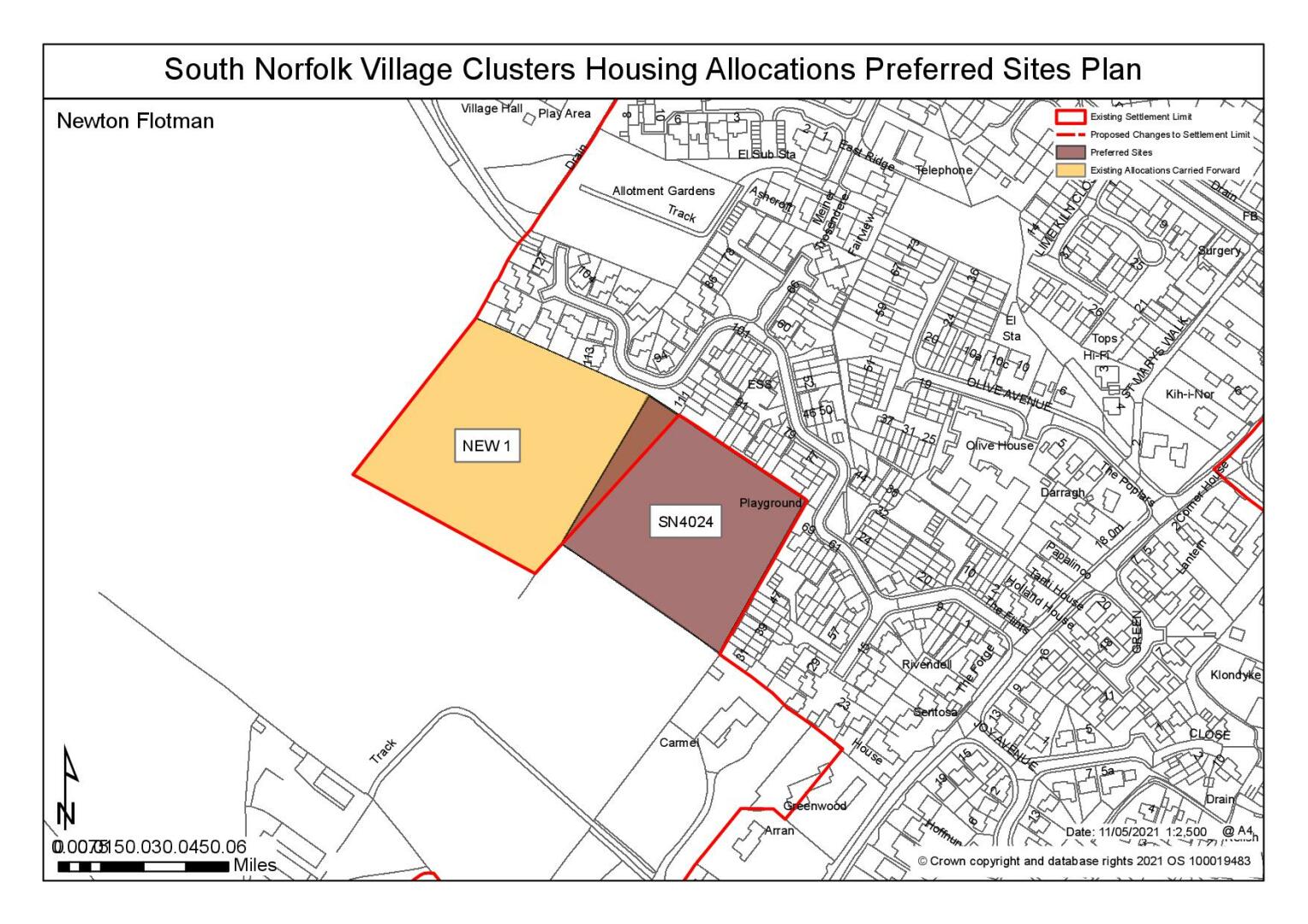
The Settlement Limit has been drawn to include the main built form of the settlement and include the allocated land, NEW1 made within the 2016 Site Allocations Plan. The village hall, rectory and church are excluded from the Settlement Limit, as is the animal feed mill and all housing on the east of Ipswich Road.
Swainsthorpe
The Settlement Limit has been drawn to include the main built form of the settlement, preventing further extension into the surrounding countryside. Due to the limited services and facilities available, the narrowness of local roads, the boundary has been drawn to allow for only very limited infill.
No alterations are proposed to the existing settlement limits within this cluster.
(37) QUESTION 96: Do you agree with the extent of the Settlement Limit and any changes proposed? If not, please explain what further changes should be made.
Preferred and Shortlisted Sites
7 sites have been promoted for consideration, of which 1 was identified as a preferred site and 1 site was shortlisted.
Preferred Sites
On the basis of the assessment undertaken the following site(s) have been identified as a preferred allocation:
|
Site: SN4024, Land off Alan Avenue, Newton Flotman |
|
Preferred for up to 25 dwellings on a site of 1.1 hectares Reasoned justification: The site is well related to services and facilities within Newton Flotman. The site is directly adjacent to the existing allocation (NEW1), where the layout will need to take into account appropriate boundaries and will be subject to achieving safe and suitable access. |
|
|
(60) QUESTION 97: Do you support or object to the allocation of the preferred site? Please add additional comments to explain your response and please specify which site(s) you are referring to. If the site is allocated do you think there are any specific requirements that should be set out in the allocation policy?
Shortlisted Sites
On the basis of the assessment undertaken the following site(s) have been shortlisted:
|
Site |
Location and reasons not preferred for allocation: |
|
SN4025 |
Land off Grove Way, Newton Flotman Shortlisted for up to 25 dwellings on a site of 1.1 hectares. There is existing residential development located to the eastern boundary of the site, where development to the east would be more reflective of the form and character of the area. Few site constraints. |
Rejected Sites
The following site(s) were promoted for development but have been rejected on the basis of information available at the time of assessment.
|
Site |
Location and Reasons for Rejection |
|
SN0191 |
Church Road, Swainsthorpe Unresolvable highway issues and impact on landscape. Access to the site is via a private drive which would need upgrading where it is not clear whether the land is within the applicant's ownership or whether it would involve the requirement for third party land. Furthermore, development of the site is considered to represent a breakout into the wider countryside to the south and east, which would harm the landscape/townscape of Swainsthorpe |
|
SN0542 |
The Paddock, East Side of the Vale, Swainsthorpe The site is considered to be remote from services and facilities in Swainsthorpe where highway safety concerns have also been identified. Development is also considered to have an adverse impact on the landscape and townscape representing a breakout into the open countryside and would be highly visible from Church Road. Furthermore, it would also impact upon the setting of the Henstead Union Workhouse which is a non-designated heritage asset. |
|
SN0594 |
Lowlands, Ipswich Road, Newton Flotman The site is considered to be unreasonable as an allocated site. Access is to the site is gained via the A140 where accessing services and facilities would require crossing the road, which is considered to be unsuitable and unsafe. The A140 is a Corridor of Movement where stopping/turning movements would be unacceptable. Furthermore, development of the site is also considered to have a landscape impact as it slopes down towards the River Valley. It is considered that these issues cannot be mitigated against. |
|
SN0603 |
Land off Church View, Swainsthorpe The harmful impact on the existing townscape and landscape. The site is situated on land that is elevated to the north of Swainsthorpe where it is highly visible within the landscape, particular in the approach to the village from the A140. It is not considered that the landscape impact could be mitigated through screening and a development of reduced scale would not sufficiently address this concern. |
|
SN3002 |
Land to the rear of Briar Lane, Swainsthorpe The access point at Briar road being a narrow public right of way where the site has limited frontage to provide safe access. Development of the site would also impact upon the setting of Swainsthorpe Church grade II* listed building which is currently unbuilt in character and provides a rural connection to the south of the church. |
(10) QUESTION 98: Do you think that any of the shortlisted or rejected sites should be allocated instead of, or in addition to, the preferred site? Please add additional comments to explain your response and please specify which site(s) you are referring to.
(15) QUESTION 99: Do you think that any of the shortlisted sites should be rejected? Please add additional comments to explain your response and please specify which site(s) you are referring to.
To find out more about the Village Clusters Housing Allocations Plan, please visit our Virtual Exhibition.