
South Norfolk Village Clusters Housing Allocations Plan (Reg. 18 Draft)
42. Tivetshall St Mary and Tivetshall St Margaret
Form and character
Tivetshall St Mary
Development in the parish is concentrated along The Street/Rectory Road in a linear form comprising mainly single plot development. Development is also concentrated around School Road which is the dividing line between the parishes of Tivetshall St Mary and Tivetshall St Margaret. Isolated clusters of development are located at Rectory Road but these are away from the facilities that the Tivetshalls share. Development in the remainder of the parish comprises individual dwellings and farmsteads. The village has an open rural character derived from the tree and hedge planting and views of the surrounding open countryside.
Tivetshall St Margaret
Development is concentrated along Green Lane, School Road and The Street in a linear form characterised by single plot development. This area is contiguous with development lying within the parish of Tivetshall St Mary and forms a single area of settlement joining both parishes.
Services and Community Facilities
There is a limited range of facilities shared by the Tivetshalls; a primary school and village hall which are located along the parish boundary between the two settlements. A public house is located away from the built-up areas on the A140 Norwich-Ipswich road. There are some opportunities for recreation and there is a limited bus service.
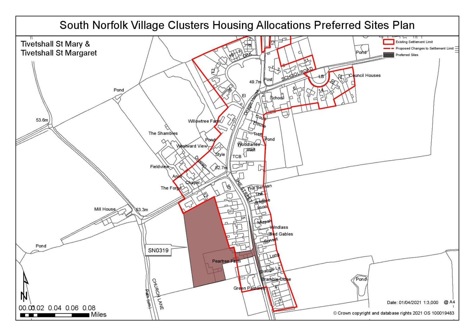
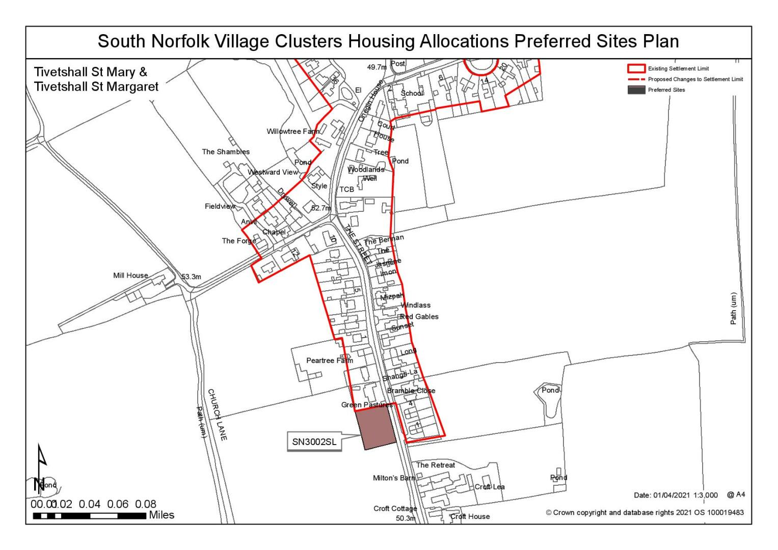
Settlement Limit and Constraints
The Settlement Limit has been drawn around the existing built-up area where the two parishes meet. It maintains the physical separation between the two built up areas to the south of The Street to prevent further extension of development into the surrounding countryside whilst allowing for limited infill development within it. Outlying areas, further from facilities have been excluded from the defined Settlement Limit. No alterations are proposed to the existing Settlement Limit.
(5) QUESTION 143: Do you agree with the extent of the Settlement Limit and any changes proposed? If not, please explain what further changes should be made.
Preferred and Shortlisted Sites
10 sites have been promoted for consideration, of which 2 were identified as preferred allocation sites and 2 have been shortlisted.
Preferred Sites
On the basis of the assessment undertaken the following site(s) have been identified as a preferred allocation:
|
Site: SN0319, Pear Tree Farm, West of The Street, Tivetshall St Margaret |
|
Preferred for up to 25 dwellings on a site of 1 hectare. Reasoned justification: The site is located close to the school and village hall and adjacent to the settlement limits and, although there are no footways there are verges for walkers to step off the carriageway. Development on the site would read as part of the existing village and would be visually contained by field boundaries to the west and south with limited open views. Therefore, whilst development would disrupt the existing linear pattern the site would allow infill without significant incursion into open countryside. Potential contamination will need to be investigated but it is likely that this can be mitigated. The Highways Authority have confirmed that access would need to be widened from The Street through demolition of the old disused barn. |
|
|
(8) QUESTION 144: Do you support or object to the allocation of the preferred site? Please add additional comments to explain your response and please specify which site(s) you are referring to. If the site is allocated do you think there are any specific requirements that should be set out in the allocation policy?
|
Site: SN3002SL, Land south of Green Pastures, west of The Street, Tivetshall St Margaret |
|
Preferred for a Settlement Limit Extension on a site of 0.18 hectares. Reasoned justification: The site is considered to be a reasonable extension to the existing settlement limit. It is located relatively close to the school and village hall and is immediately adjacent to the settlement limit to the north and opposite the settlement limit to the east. The site is currently residential curtilage and already appears as part of the form of the village, albeit with a strong frontage hedge line which would need to be partially removed for access. New development in this location would read as part of the existing village fronting The Street, mirroring the residential development directly opposite. It would be a rounding-off of the built form without incursion into open countryside as the southern boundary is delineated by a public footpath. |
|
|
(9) QUESTION 145: Do you support or object to the proposed use of the site? Please explain your reasons
Shortlisted Sites
On the basis of the assessment undertaken the following site(s) have been shortlisted:
|
Site
|
Location and Reasons not preferred for allocation: |
|
SN0318 |
Pear Tree Farm, west of The Street Shortlisted for up to 10 dwellings on a site of 0.6 hectares. It should be noted that this is not an additional site, it is a smaller part of site SN0319 with the same proposed access point from The Street and, if allocated, it would be instead of SN0319. The site is located close to the school and village hall and adjacent to the settlement limits. Although there are no footways there are verges for walkers to step off the carriageway. The site would read as part of the existing village with existing residential development to the east and development would be visually contained by field boundaries to the west and south with limited open views. Therefore, whilst development would disrupt the existing linear pattern the site would allow infill without incursion into open countryside. Potential contamination from the previous use will need to be investigated but it is likely that this can be mitigated. Highways officers have confirmed that access would need to be widened from The Street through demolition of the disused barn. |
|
SN2103 |
Land north of School Road Shortlisted for up to 15 dwellings on a site of 0.9 hectares. The site is located close to the school and village hall and adjacent to the settlement limits. Development in this location would read as part of the existing village and is visually contained with limited open views from the north. There would be some impact on Elm Farm to east which would be mitigated if the eastern hedgerow and trees were retained and enhanced. Highways officers have confirmed that all/most of the frontage hedge/trees would need to be removed to achieve an access into the site. School Road narrows to the east at this point and there are potential access constraints which it is may be possible to overcome through a reconfiguration of the local road layout but this would need to be agreed with NCC Highways. NCC highways to confirm if could turn road into site making this the primary road and make remainder of School Road to the east into a side road. |
Rejected Sites
The following site(s) were promoted for development but have been rejected on the basis of information available at the time of assessment.
|
Site |
Location and Reasons for Rejection |
|
SN0317SL |
Land south of Mill Road The site is considered an unreasonable extension to the existing settlement limits due to highway concerns. Highways officers have commented on the inadequacy of Mill Road given its narrow width and poor junction with The Street. The site is located close to the school and village hall and adjacent to the settlement limit, although there is a lack of a continuous footpath. Development in this location would represent a breakout to the west and would continue a limited form of ribbon development along Mill Road. Potential contamination from the previous land use will need to be investigated but it is likely that this can be mitigated. |
|
SN2041 |
Land east of Tivetshall The site is considered unreasonable due to its excessive scale, 18.9 ha (472 dwellings) in relation to the existing village. The possibility of smaller parts being developed has been considered but no alternatives have been found reasonable. Areas of the site are located close to the school and village hall and adjacent to the settlement limits, but the majority is not well connected. Development in this location would excessively disrupt the existing linear form of the village, extending the village into the open countryside to the detriment of its landscape setting. The School Road access is detached from the village and would not be acceptable as it would extend into the open countryside on a narrow rural road. Access from The Street is very restricted would involve the removal of a hedgerow/trees adjacent to the Listed Building. In both instances, development at this scale would be harmful to highway safety using either access point. |
|
SN2042REVA |
Land south of Rectory Road The site lacks connectivity to the village, as it is located at the southern edge some distance from the settlement limit. It does not reflect the existing form and character of development as the majority of the site is located behind the road frontage. It would also visually extend the village into the countryside and would be detrimental to the landscape setting of the village with no naturally delineated boundaries. The frontage could not achieve adequate visibility for access. |
|
SN2042REVB |
Land south of Rectory Road The site is considered unreasonable due to its lack of connectivity to the village, being located at the southern edge some distance from the settlement limit. It is a reduced site area and does run along the road frontage, reflecting the existing form and character of the adjacent development. In this respect it is more acceptable than the associated larger site: SN2042A. The alternative site also results in a longer frontage which could meet highway visibility requirements although would result in the loss of the hedgerow. However, it would visually extend the village into the countryside and would be detrimental to the landscape setting of the village with no naturally delineated boundaries. |
|
SN3006 |
North of Croft Lea, east of The Street The site is considered unreasonable due to its lack of connectivity to the village and its intrusion into the open countryside, impacting on both a heritage asset and the local ecology. Whilst it is relatively close to the school and village hall and adjacent to the settlement limits it is physically less well connected due to it being largely behind existing development. It would disrupt the existing linear form of the village and visually extend the village into open countryside which would be detrimental to the landscape setting of the village. Development of this scale would be out of character and would impact on the setting of designated Listed Building to the south. Access is achievable from The Street but this would require the loss of the frontage hedgerow and trees which would further adversely impact on the Listed Building. |
|
SN4006 |
Land west of Hales Street The site is considered to be unreasonable for allocation due to its very remote location away from the village and lack of access to services, in particular the distance to the primary school along unlit rural roads with no footpaths. There are site constraints; overhead lines and telegraph poles along the northern and eastern boundary, a UKPN sub-station in the NE corner, ponds in NW corner and mature trees within the site. These site constraints could be mitigated but would reduce the developable area. Any impacts on townscape and landscape could be mitigated through design and landscaping to include retention of the eastern boundary hedgerow. |
(9) QUESTION 146: Do you think that any of the shortlisted or rejected sites should be allocated instead of, or in addition to, the preferred site? Please add additional comments to explain your response and please specify which site(s) you are referring to.
(3) QUESTION 147: Do you think that any of the shortlisted sites should be rejected? Please add additional comments to explain your response and please specify which site(s) you are referring to.
To find out more about the Village Clusters Housing Allocations Plan, please visit our Virtual Exhibition.