South Norfolk Village Clusters Housing Allocations Plan (Reg. 18 Draft)
28. Pulham Market and Pulham St Mary
Form and character
Pulham Market
Pulham Market is a nucleated village which has developed around an attractive village green. A large number of attractive buildings front the green and are included within a larger conservation area. The village green affords an open aspect for the village centre. There has been considerable development in the second half of the twentieth century to the north and west of the conservation area at Falcon Road, Julians Way, Mill Close and Springfield Walk. In addition, infill development has occurred within the built-up area of the village.
Land around the village is gently rolling and offers distant views across mainly arable land. This gives the village its attractive rural setting. The former route of the B1134 (Tattlepot Road) provides a good link to the A140 linking to Norwich and Long Stratton to the north and Diss to the south. To the west, there is a relatively good link to Harleston.
Pulham St Mary
The main village is located centrally within the parish. It developed in a linear form east-west with development later being located on a north-south axis along North Green Road, Station Road and Mill Lane, and later still, estate development at Goldsmith Way, Bond Close and Chestnut Road. This has resulted in a village with both linear and nucleated features. The ribbon of local authority housing on Norwich Road reinforces the linear form at the western end of the village.
In the centre of the village the grounds of 'The Grange' form a large undeveloped area which adds to the open character of the village, as does the area to the north of The Street around the churchyard. Large parts of the village containing a variety of historic buildings fall within a Conservation Area, which extends to the river meadows south of The Street as far as Dirty Lane. The village has good road access via Starston to Harleston to the east and via Pulham Market to the A140 to Norwich, Long Stratton and Diss to the west.
Services and Community Facilities
The settlements have a range of social and community facilities including a preschool, primary school, shop, post office and village hall, public houses, allotments, bowling green, tennis court and recreation ground. There is also a GP Surgery with dispensary and a regular bus service.
Settlement Limit and constraints
Pulham Market
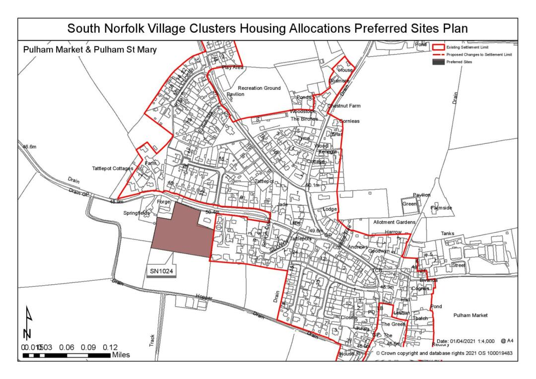
The Settlement Limit has been drawn to include the main built form of the settlement. There are some opportunities for limited infill within the Settlement Limit.
There is some capacity in the primary school and there are possible opportunities for expansion. This may require larger than minimum scales of growth to justify. Further exploration will be needed to ensure primary school needs are appropriately met.
Pulham St Mary
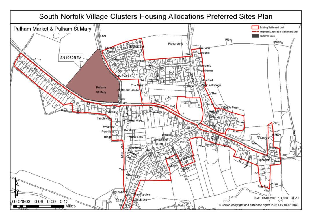
The Settlement Limit has been drawn to include the main built form of the settlement but to exclude the churchyard and the grounds of The Grange which contribute to the character of the village.
No alterations are proposed to the existing settlement limits within this cluster.
(3) QUESTION 100: Do you agree with the extent of the Settlement Limit and any changes proposed? If not, please explain what further changes should be made.
Preferred and Shortlisted Sites
15 sites have been promoted for consideration, of which 14 were assessed. 2 have been identified as preferred allocation site and 2 further sites were shortlisted. The unassessed site (reference SN008SL) is below the threshold for a site allocation and already lies within the defined Settlement Limit. Therefore, this site has not been subject to detailed consideration.
Preferred Sites
On the basis of the assessment undertaken the following site(s) have been identified as a preferred allocation:
|
Site: SN1024, Ladbrookes, Tattlepot Lane, Pulham Market |
|
Preferred for up to 20 dwellings on a site of 1.3 hectares. Reasoned justification: The site is considered suitable for allocation. The site relates well to the existing settlement and services and facilities within it. The site is prominent within the landscape but impacts could be mitigated with appropriate landscaping. A continuous frontage footway linking to tie in with provision at PUL1 would be required. |
(7) QUESTION 101: Do you support or object to the allocation of the preferred site? Please add additional comments to explain your response and please specify which site(s) you are referring to. If the site is allocated do you think there are any specific requirements that should be set out in the allocation policy?
|
Site: SN1052REV, Land at Norwich Road, Pulham St Mary |
|
Preferred for up to 50 dwellings on a site of 2 hectares. Reasoned justification: The site is considered suitable for allocation. The site is larger than typical sites sought within the Village Cluster areas, however this is justified on the basis that it could facilitate highway improvements along Poppy's Way. In other respects, the site is well related to the existing settlement and the services and facilities within it. The site is prominent in the landscape, reducing the overall scale of development would avoid a significant detrimental impact on the landscape and townscape. Development is preferred to the eastern end of the site. |
(7) QUESTION 102: Do you support or object to the allocation of the preferred site? Please add additional comments to explain your response and please specify which site(s) you are referring to. If the site is allocated do you think there are any specific requirements that should be set out in the allocation policy?
Shortlisted Sites
On the basis of the assessment undertaken the following site(s) have been shortlisted:
|
Site |
Location and Reasons not preferred for allocation: |
|
SN0418 |
Land at Cook's Field, Jocelyn Close, Pulham Market Shortlisted for up to 15 dwellings on a site of 0.66 hectares. The site is considered reasonable for an allocation of up to 15 dwellings, subject to highways considerations and landscape mitigation. Highways have raised concerns about the potential to form an acceptable access and the suitability of the local highway network. The site is not likely to be suitable for development at higher densities than promoted due to edge of settlement location. |
|
SN1027 |
Land east of Goldsmith Way, Pulham St Mary Shortlisted for up to 20 dwellings on a site of 1.27 hectare. The site is well related to the existing settlement and a range of services and facilities. However, whilst the Highway authority have indicated that a suitable access could be formed to the site, Poppy Lane is constrained and would require improvement. Allocation of the site would include an area for Pubic Open Space (POS). |
Rejected Sites
The following site(s) were promoted for development but have been rejected on the basis of information available at the time of assessment.
|
Site |
Location and Reasons for Rejection |
|
SN0166 |
Gosmore, w/o Colegate End Lane, Pulham Market The development of the site would have detrimental impacts on townscape and designated heritage assets could not be reasonably mitigated |
|
SN0363SL |
The Maltings, Station Road, Pulham St Mary The site is not suitable as an extension to the Settlement Limit due to the detrimental impact it would have on the townscape and the setting of The Maltings. Access to the site also appears problematic. |
|
SN0398 |
Land south of The Street, Pulham St Mary The site is not considered to be suitable due to a detrimental impact on the form and character of the existing settlement, as well as an adverse impact on the setting of the church. |
|
SN0407 |
Land north of Colegate End Road, Pulham Market The site is separated from the main settlement and would have a detrimental impact on the form and character of the area (townscape). There are also highways concerns as it is situated on a narrow land and close to a bend in the road. |
|
SN0430 |
Land east of Station Road, Pulham St Mary There are concerns over the suitability of the site access, the impact on the setting of the Conservation Area and the Cordon Sanitaire of the STW. |
|
SN0575 |
Flanders Meadow, Station Road, Pulham St Mary The site relates poorly to main settlement and development of this site would have a detrimental impact on the rural character of area. |
|
SN1053 |
Land west of Mill Lane, Pulham St Mary The site has an acceptable relationship with local services and is relatively contained within the landscape. However, the site would have poor relationship with the townscape due to the orientation of the dwellings on the opposite side of Mill Lane to the east. |
|
SN2095 |
East of Colegate End Road, Pulham Market The development of the site would have an unacceptable impact on townscape and heritage assets that could not be mitigated. |
|
SN2096 |
West of Mill Lane, Pulham Market Development of the whole site would have unacceptable impacts on landscape, townscape, the highway network and heritage assets. Development of south eastern corner is the only area likely to acceptable, subject to mitigation of resolution of highway constraints and flood risk issues. The Highway Authority have raised concerns about the capacity of the local highway network. |
|
SN4085SL |
Land adjacent Orchard Court, Station Road, Pulham Market The site is remote and has poor connectivity to the main settlement. As a result the development of the site would have a detrimental impact on the landscape and the character and appearance of the area. |
(10) QUESTION 103: Do you think that any of the shortlisted or rejected sites should be allocated instead of, or in addition to, the preferred site? Please add additional comments to explain your response and please specify which site(s) you are referring to.
(3) QUESTION 104: Do you think that any of the shortlisted sites should be rejected? Please add additional comments to explain your response and please specify which site(s) you are referring to.
To find out more about the Village Clusters Housing Allocations Plan, please visit our Virtual Exhibition.


