South Norfolk Village Clusters Housing Allocations Plan (Reg. 18 Draft)
47. Woodton and Bedingham
Form and character
Woodton
The village has a predominantly nucleated settlement pattern based around Hempnall Road, The Street, Triple Plea Road and Chapel Hill. Some limited estate scale development has taken place in the village. The village is set in an attractive valley landscape being situated on a south facing valley slope with a smaller tributary valley to the east. The attractive setting of the village, the views of the surrounding countryside from various points of the village, and the good tree and hedge planting throughout, combine to give the village its attractive rural character. The B1527 provides a link to the A140 and Long Stratton to the west, whilst the B1332 to the east of the village provides links to Norwich and Bungay.
Bedingham
The northern part of this parish forms part of the built-up settlement area of Woodton. The majority of the parish is sparsely populated with development concentrated along School Road, with the remaining individual dwellings and farms showing a dispersed pattern.
Services and Community Facilities
The settlement has a range of social and community facilities including a preschool, primary school, post office and shop, pub, village hall and recreation facilities. There is also a limited bus service.
Settlement Limit and Constraints
The Settlement Limit has been drawn to include the main built form of the settlement. No alterations are proposed to the existing Settlement Limit.
The primary school continues to have some capacity and options for expansion, although larger than minimum scales of growth may be needed to justify such expansion. Further exploration will be needed to ensure primary school needs can be met.
QUESTION 165: Do you agree with the extent of the Settlement Limit and any changes proposed? If not, please explain what further changes should be made.
Preferred and Shortlisted Sites
9 sites have been promoted for consideration, 2 were identified as preferred allocation sites and 1 was identified as a preferred Settlement Limit extension.
Preferred Sites
On the basis of the assessment undertaken the following site(s) have been identified as a preferred allocation:
|
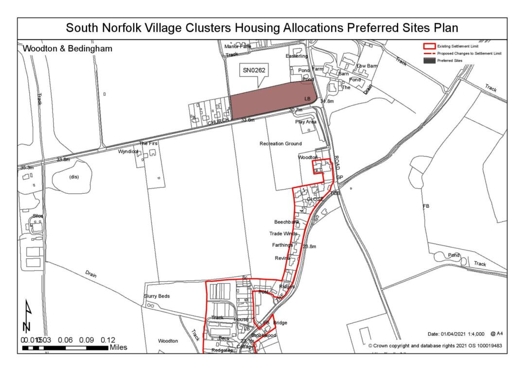
Site: SN0262, Land north of Church Road, Woodton |
|
Preferred for up 10-15 dwellings on a site of 1 hectare. Reasoned justification: The site is well located in relation to the primary school and is suitable for allocation, subject to it being demonstrated that there would not be unacceptable impact on the heritage asset to the north. Although separate from the main settlement it benefits from good connectivity and development in this location would be read in the context of the existing dwellings adjacent to the site. It would not have a significant detrimental impact on the wider landscape setting. Impacts on landscape could be mitigated if this site is developed in conjunction with other sites. Allocation of this site would not need to be reliant on the allocation of SN0268SL although if appropriate they could be combined as a single allocation to the north of Woodton. However, allocation of this site should not be at the density promoted and would need to be similar to the existing linear development adjacent to the site. A combination of development across this site, SN0268SL and SN0278 would be preferable in highway terms. |
(7) QUESTION 166: Do you support or object to the allocation of the preferred site? Please add additional comments to explain your response and please specify which site(s) you are referring to. If the site is allocated do you think there are any specific requirements that should be set out in the allocation policy?
|
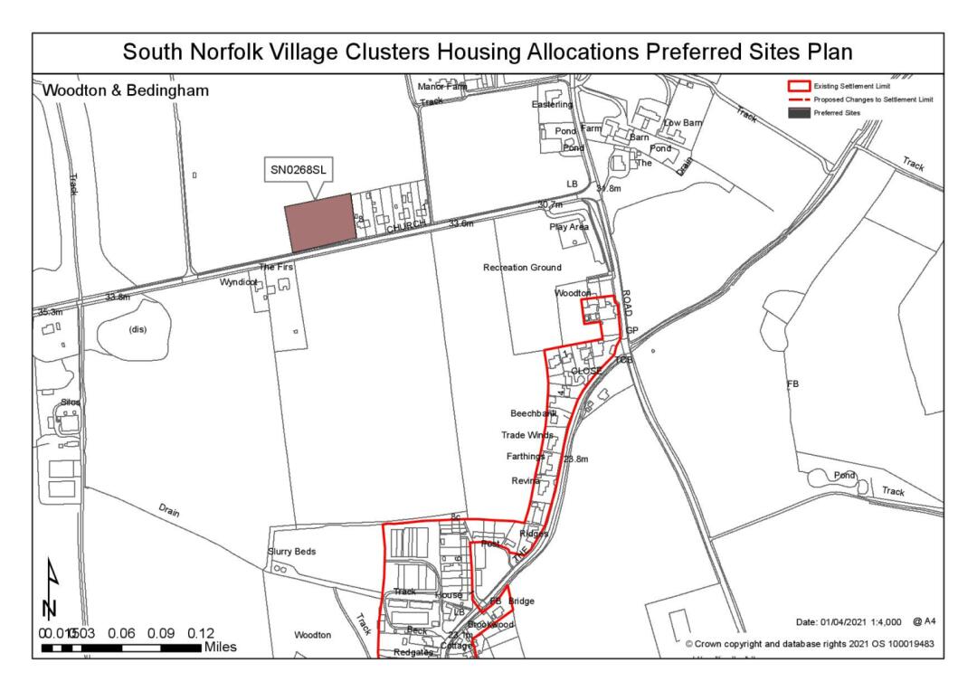
Site: SN0268SL, Land north of Church Road, Woodton |
|
Preferred for a Settlement Limit Extension on a site of 0.47 hectares. Reasoned justification: The site is considered to be a reasonable site for allocation if combined with SN0262. A linear form of development would complement the existing semi-detached properties. However, as a standalone SL site it is not considered that this would be an appropriate location for development due to its separation from the main area of development within the settlement. |
(6) QUESTION 167: Do you support or object to the proposed use of the site? Please explain your reasons
|
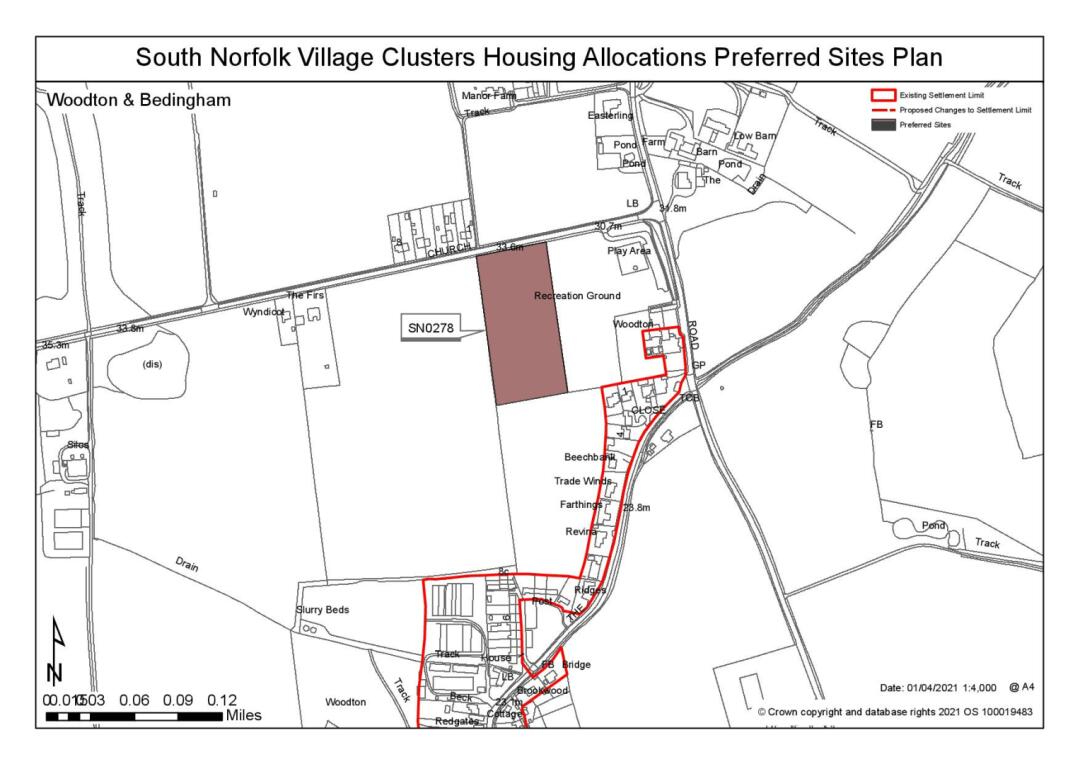
Site: (Northern End of) SN0278, Land south of Church Road, Woodton |
|
Preferred for up 25 dwellings on a site of 1 hectare. Reasoned Justification: The preferred site comprises the northern end of a larger total site that has been submitted. The allocation of the northern part of the site has the potential to create, along with the other promoted sites, a coherent development adjacent to the school and recreation ground. The allocation of the site would be subject to addressing identified highway concerns and minimising landscape impacts. The development of the land to the south of the identified site could be identified in preference to sites SN0262 and SN0268SL, if it were able to be developed in a way that enabled better links back to the services at the southern end of the village. |
(5) QUESTION 168: Do you support or object to the allocation of the preferred site? Please add additional comments to explain your response and please specify which site(s) you are referring to. If the site is allocated do you think there are any specific requirements that should be set out in the allocation policy?
Rejected Sites
The following site(s) were promoted for development but have been rejected on the basis of information available at the time of assessment.
|
Site |
Location and Reasons for Rejection |
|
SN0150 |
Land to the east of Chapel Hill and south of Hempnall Road Development in this location would have an adverse impact on the local landscape, as well as on local non-designated heritage assets. |
|
SN0231REV |
Land north of Suckling Place Whilst the site initially appears to be an obvious extension to an existing allocation, development on that site was allowed recognising that there were existing traffic movements associated with the former use of the site. There are however constraints at the crossroads junction (The Street/ Hempnall Road/ Chapel Hill) and the Hempnall Road /B1332 junction. The Street itself is also narrow, with restricted forward visibility and a poor junction with the B1332. It is not considered appropriate to extend the current allocation on the basis of the impact on the wider network. |
|
SN1009SL |
Land at the junction of Chapel Road and Sunnyside The site is considered to be unreasonable due to the landscape impact of developing it, as well as the highways access constraints. Loss of the trees and vegetation is also considered to have an adverse impact on the wider setting. |
|
SN2100 |
Land north of Hempnall Road The site is considered unreasonable due to the landscape impact that would result from its development, in particular arising from the continued linear extension of the settlement and the overall topography of the site and the surrounding land. |
|
SN2130 |
Land south of The Street The site is unreasonable due to the adverse impact that it would have on the townscape, as well as the landscape. The current open aspect forms an important feature of the streetscene as it leads into the more developed centre of the settlement. |
|
SN4052 |
Land south east of The Street, Woodton The site is considered to be unreasonable due to its scale and the adverse impact that this would have on the wider landscape setting. Access constraints to this site have also been identified which would be difficult to overcome satisfactorily. |
(2) QUESTION 169: Do you think that any of the shortlisted or rejected sites should be allocated instead of, or in addition to, the preferred site? Please add additional comments to explain your response and please specify which site(s) you are referring to.
To find out more about the Village Clusters Housing Allocations Plan, please visit our Virtual Exhibition.


