
South Norfolk Village Clusters Housing Allocations Plan (Reg. 18 Draft)
3. Aslacton, Great Moulton and Tibenham
Form and character
Aslacton and Great Moulton
The main concentrations of development within the parishes of Aslacton and Great Moulton are in three distinct settlements – the historic village cores of Aslacton and Great Moulton, and an area of largely modern development at Sneath Common.
The historic core of Aslacton is concentrated around The Street and Church Road and includes the village school.
Great Moulton is a compact settlement which has developed between a number of traditional farmsteads strung along the south side of High Green and some further farms on the north side of Old Road. The village has seen a considerable amount of modern development, with estate development such as Potters Crescent and Heather Way as well as a large amount of infill development.
The local road network comprises of mainly 'C' and unclassified roads, but the B1134 to the south of Sneath Common provides links to the A140 to the east and the B1077 and New Buckenham to the west.
Tibenham
The parish of Tibenham has a dispersed rural settlement pattern consisting of individual dwellings and farms scattered throughout the parish. The established village of Tibenham is concentrated along The Street and around the site of the old school. Further detached clusters of development exist at Pristow Green and Long Row. The main concentration of development has developed in a linear form characterised by one plot depth. Its setting in a small valley with abundant tree hedge planting along the road frontages and attractive open countryside give it a rural character.
Services and Community Facilities
The cluster has limited facilities including a pub, village hall, recreation area and limited public transport. There is a primary school situated in Aslacton.
Settlement Limit and Constraints
Aslacton & Gt Moulton
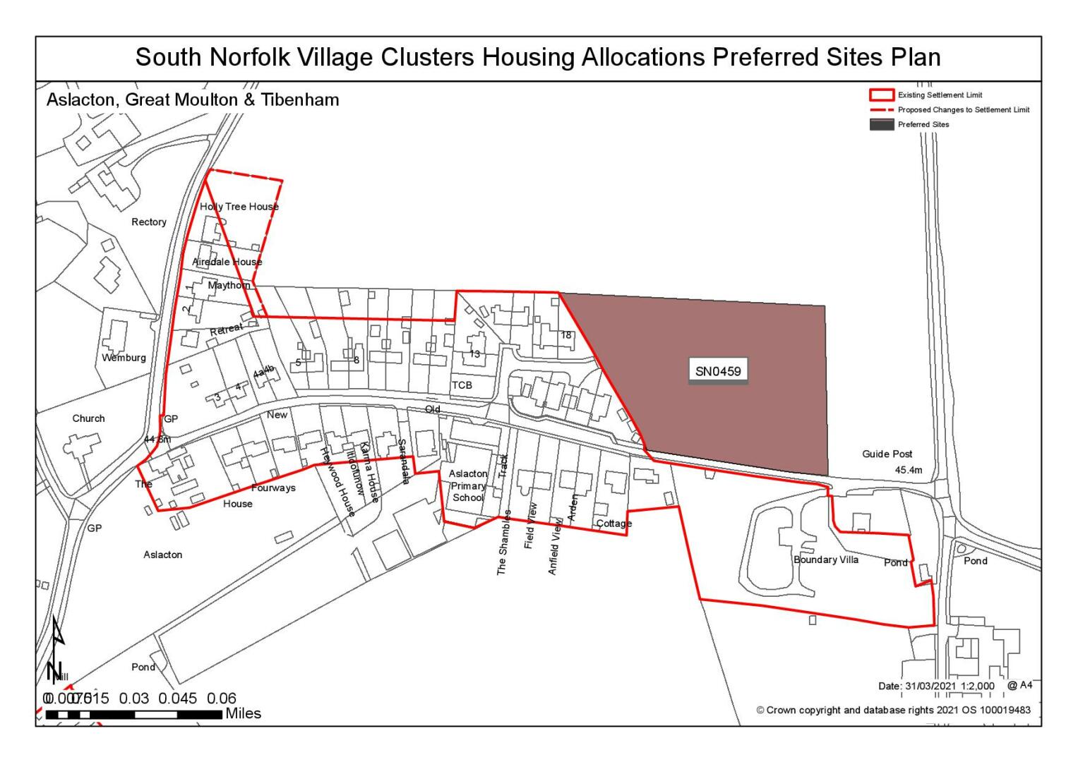
The Settlement Limit has been drawn to include the main built form of the three settlements. In addition, the boundary includes a small allocation on High Green made within the 2016 Site Allocations Plan and the former scrapyard in Aslacton. Small amendments to the Settlement Limit are proposed on Pottergate Street and at Sneath Road/Woodrow Lane to reflect planning permissions for new dwellings that have been allowed on sites adjacent to the existing Settlement Limit. These changes are shown on the policies map.
(1) QUESTION 13: Do you agree with the extent of the Settlement Limit and any changes proposed? If not, please explain what further changes should be made.
Preferred and Shortlisted Sites
16 sites have been promoted for consideration, of which 1 has been preferred and 1 has been shortlisted. The remaining sites (Reference SN2003 and SN3001SL) have not been subject to detailed consideration. SN2003 was subject to a detailed application (District Reference 2020/0751), which has now been approved. SN3001SL also now has planning permission (District Reference 2019/2523).
Preferred Site(s)
On the basis of the assessment undertaken the following site(s) have been identified as a preferred allocation:
|
Site: SN0459, Land off Church Road, Aslacton |
|
Preferred for up to 25 dwellings on a site of 1 hectare Reasoned justification: Site is well related to Aslacton Primary School. Whilst highway and landscape concerns have been raised it is considered that these could be mitigated through footpath extensions and appropriate landscaping. In order to be consistent with the aims of the Village Cluster Housing Allocation, it is proposed that only 1 hectare of the promoted site is allocated for development. The proposed allocation would therefore comprise the western half the promoted site immediately adjacent to existing development. |
|
|
(11) QUESTION 14: Do you support or object to the allocation of the preferred site? Please add additional comments to explain your response and please specify which site(s) you are referring to. If the site is allocated do you think there are any specific requirements that should be set out in the allocation policy?
Shortlisted Sites
On the basis of the assessment undertaken the following site(s) have been shortlisted:
|
Site |
Location and reasons not preferred for allocation: |
|
SN2118 |
South of Sneath Road, Aslacton Shortlisted for a Settlement Limit Extension on a site of 0.54 hectares. The site is considered potentially suitable as a limited Settlement Limit extension as there are no significant concerns in terms of townscape, landscape or heritage, although identified flood risk issues would need to be overcome for the site to be developed. However, the site has limited access to services and no safe walking route to school. |
Rejected Sites
The following site(s) were promoted for development but have been considered to be unreasonable alternatives on the basis of information available at the time of assessment.
|
Site
|
Location and Reasons for Rejection |
|
SN0365SL |
Land east of Cherry Tree Road, Tibenham. The site is remote from existing settlements with very limited access to services. It is also considered that the development may impact detrimentally on nearby heritage assets. |
|
SN0554SL |
Land at Hallowing Lane, Great Moulton. The site is subject to a number of constraints, including highways constraints, heritage and trees. There is no safe walking route to the primary school. |
|
SN0555 |
Land off Old Road (adjacent to Hallowing Lane), Great Moulton. The site is subject to a number of constraints, including highways constraints, heritage and trees. There is no safe walking route to the primary school. |
|
SN0557SL |
Sites between Ketts Farm and Orchard Farm, Great Moulton. The site is considered to be unreasonable. The site is subject to a number of constraints, including highways constraints, heritage and flood risk. There is no safe walking route to the primary school. |
|
SN1041 |
Land at Pottergate, Aslacton. The site is remote from existing settlements with very limited access to services. There is no safe walking route to school. The site is considered to have detrimental impacts in terms of landscape, townscape and heritage and is subject to flood risk constraints. |
|
SN1042 |
Land at Church Road, Aslacton. The site is remote from existing settlements with very limited access to services. There is no safe walking route to school. The site is considered to have detrimental impacts in terms of landscape, townscape and heritage and is subject to flood risk constraints. |
|
SN2005 |
West of Woodrow Lane, Aslacton. The site is remote from existing settlements with very limited access to services. There is no safe walking route to school. The site is considered to have detrimental impacts in terms of landscape, townscape and heritage and is subject to flood risk constraints. |
|
SN2008SL |
Overwood Lane, Great Moulton. It is remote from existing settlements, with resultant detrimental impacts in terms of landscape and townscape. It has poor connectivity to services and no safe walking route to school. Potential impact on setting of nearby listed buildings. |
|
SN2068 |
Cherry Tree Farm, Great Moulton. Site is breakout from the existing pattern of built form and would impact on the existing rural approaches to existing settlements. Access to site potentially constrained and would require significant loss of hedgerow. Proximity to railway line would potentially impact on the amenity of future residents. Site has limited access to services and facilities. There is no safe walking route to school. No footpath access from existing settlements to proposed retail provision. |
|
SN2102SL |
Long Row, Tibenham. Site is remote with poor access to services. Concern over potential impact on nearby heritage assets |
|
SN2112 |
Back Barn Road, Tibenham Access to services is limited. Location and form of development considered to have significant impact on landscape and the form and character of settlements. Concerns over impact on capacity of local highway network. |
|
SN3008REV |
East of Pristow Green Lane, Tibenham Access to services is limited. Location and form of development considered to have significant impact on landscape and the form and character of settlements. Concerns over impact on capacity of local highway network. |
(18) QUESTION 15: Do you think that any of the shortlisted or rejected sites should be allocated instead of, or in addition to, the preferred site(s)? Please add additional comments to explain your response and please specify which site(s) you are referring to.
QUESTION 16: Do you think that any of the shortlisted sites should be rejected? Please explain your response and please specify which site(s) you are referring to.
To find out more about the Village Clusters Housing Allocations Plan, please visit our Virtual Exhibition.