
South Norfolk Village Clusters Housing Allocations Plan (Reg. 18 Draft)
40. Thurlton and Norton Subcourse
Form and character
Thurlton
The main concentration of development has developed in a linear settlement form based upon the historical road network based along Beccles Road, Church Road and Low Road although modern estate development off Beccles Road has resulted in a more nucleated form in this area. In addition to development, the village has experienced a considerable amount of modern infill development which has generally respected the existing character of frontage development. There is a detached group of houses at College Road, whilst the wooded grounds of All Saints Church and The Rectory provide a 'soft' edge to the village which makes an important contribution to its rural character.
The village is set in an attractive landscape with Thurlton Marshes and the Broads to the north and a small tributary valley immediately to the west with views of the surrounding countryside from within parts of the built-up area. Part of the parish lies with the Broads Authority area. Beccles Road provides a relatively a good link to Beccles and the A143 to the south, whilst the nearby B1136 links to the A146 and Loddon to the west and Haddiscoe and the A143 to Great Yarmouth to the east.
Norton Subcourse
The main concentration of development within the parish is based along Loddon Road/The Streeand adjoins the main built-up area of Thurlton. There is a small scattering of development based along Low Road with development in the remainder of the parish comprising dispersed individual dwellings and farmsteads. The village is set within a small tributary valley with the marshland of the River Yare within the Broads immediately to the north. The good open views of the surrounding landscape from within many parts of the built-up area, together with areas of good tree and hedge planting, provide the village with its essentially rural character.
The former B1140 provides a link to the A143, A146 and Beccles to the south, and to Reedham via the Reedham Ferry to the north. The B1136 links the village to Haddiscoe and Gt Yarmouth to the east and Loddon to the west.
Services and Community Facilities
The cluster has a range of social and community facilities including a preschool, primary school, post office and shop, public house and village hall. There are also opportunities for recreation and employment in the settlement. There is also a bus service serving the village and it has the benefit of main sewerage is available.
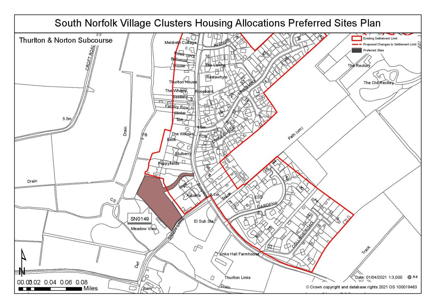
Settlement Limit and Constraints
Thurlton
The Settlement Limit includes the main built form of the settlement.
Norton Subcourse
The Settlement Limit includes the main built form of the settlement. No alterations are proposed to the existing Settlement Limit.
(3) QUESTION 138: Do you agree with the extent of the Settlement Limit and any changes proposed? If not, please explain what further changes should be made.
Preferred and Shortlisted Sites
2 sites have been promoted for consideration, of which 1 has been identified as a preferred allocation site.
Preferred Sites
On the basis of the assessment undertaken the following site(s) have been identified as a preferred allocation:
|
Site: SN0149, Land adjacent to Holly Cottage, west of Beccles Road, Thurlton |
|
Preferred for up to 12 dwellings on a site of 0.51 hectares Reasoned justification: The adjoining site has a partially implemented planning permission within the current settlement limit. This site is an extension to that using the same access. It is within the village with good access to services and the school. It will have a limited impact on the landscape which can be mitigated. Drainage requirements and retention of trees to the south will determine density. Adequate access will need to be achieved for an increased number of dwellings utilising the approved access from Beccles Road through the adjacent site |
|
|
(7) QUESTION 139: Do you support or object to the allocation of the preferred site? Please add additional comments to explain your response and please specify which site(s) you are referring to. If the site is allocated do you think there are any specific requirements that should be set out in the allocation policy?
Rejected Sites
The following site(s) were promoted for development but have been rejected on the basis of information available at the time of assessment.
|
Site |
Location and Reasons for Rejection |
|
SN0309 |
Land south of Loddon Road, Norton Subcourse The site is adjacent to the settlement limit where development is characterised by a linear form of development. However, the site is out of scale with the village and would extend into the landscape elongating the village in wider views to the west with a detrimental impact on the setting of the listed church. There is no continuous footpath back to the village and there would not be a safe walking route to school. The constraints of the site in respect of the ditch and surface water flooding reduces the developable area and frontage hedging would have to be removed for access. |
QUESTION 140: Do you think that any of the rejected sites should be allocated instead of, or in addition to, the preferred site? Please add additional comments to explain your response and please specify which site(s) you are referring to.
To find out more about the Village Clusters Housing Allocations Plan, please visit our Virtual Exhibition.