
South Norfolk Village Clusters Housing Allocations Plan (Reg. 18 Draft)
43. Toft Monks, Aldeby, Haddiscoe, Wheatacre and Burgh St Peter
Form and Character
Toft Monks
Development within the parish has been concentrated around the junction of Yarmouth Road/Beccles Road, Post Office Road/Mardle Road and along Bulls Green Lane. Development within the remainder of the parish comprises individual dwellings and farmsteads.
The main village comprises two distinct areas which are separated by the open field to the south of Mardle Road and which is important in contributing towards the generally open appearance from which much of the attractive rural character of the village is derived.
Development along Yarmouth Road, both sides and along the west side of Bulls Green Lane has taken the form of ribbon development. Along Beccles Road development is limited to the east of the road whilst to the west is the open field separating the two parts of the village. To the north of Mardle Road is Grade 2 agricultural land.
Aldeby
Development within the parish has been concentrated in two separate conurbations at The Street and around Common Road. Individual dwellings and farmsteads are dispersed throughout the remainder of the parish.
Development at The Street is linear in form and comprises one plot depth along The Street, Beccles Road and Rectory Road. It is set in open countryside with the attractive Waveney Valley to the south and close to the Broads.
Development at Common Road comprises a small concentration of dwellings centred on the crossroads of Dun Cow road, Common Road and Lily Lane.
The settlement is characterised by tree and hedge planting along the road frontages although the open nature of the western side of Dun Cow Road, north of the crossroads, affords particularly good views of the surrounding countryside.
Much of the southern part of the parish lies within the Broads Authority area.
Haddiscoe
Development along The Street and Thorpe Road has resulted in a linear form of settlement characterised by one plot development the main exception being the Tayler and Green housing at Mock Mile Terrace. The mainly undeveloped nature of the north side of Thorpe Road provides attractive views towards the River Waveney, which contribute to the rural character of the area. The detached area of development at Rectory Road also displays a strong linear form.
The settlement is an attractive valley landscape with the Waveney Valley to the north and a small tributary valley to the west. The settlement is also in close proximity to the Broads.
Wheatacre & Burgh St Peter
Development within the parish has been concentrated around the crossroads formed by Beccles Road, Staithe Road, Pitt Road and Mill Road. The remainder of the parish comprises a small number of widely dispersed individual dwellings and farmsteads with the exception of the small concentration of development at the River Waveney Centre in the east of the parish. Part of the built-up area of Burgh St Peter lies within the adjacent parish of Wheatacre and for the purposes of a village Settlement Limit is included within the boundary of Burgh St Peter.
The village of Burgh St Peter has developed a linear settlement form comprising one plot depth along Beccles Road, Staithe Road, Mill Road and Pitt Road. Good tree and hedge planting exists especially along the eastern side of Pit Road, whilst elsewhere within the village a more open character prevails allowing for good views of the surrounding countryside, in particular the Waveney Valley which lies to the south and east and the Broads which are in close proximity to the north, south and east of Burgh St Peter.
Services and Community Facilities
The village cluster is served by a pub, garage, village hall, bowling green and primary school. There is also a limited bus service.
Settlement Limit and Constraints
Toft Monks
The Settlement Limit has been drawn to reflect the existing settlement form and to prevent further development extending into the surrounding open countryside whilst providing for some limited infill development within it.
Aldeby
The settlement limits have been drawn around the two main concentrations of development centred on The Street and Common Road. They have been drawn to allow for very limited infill due to the lack of facilities locally and to prevent the further extension of development into the surrounding open countryside, in particular the adjacent valley landscape of the Waveney valley.
Haddiscoe
The Settlement Limit has been drawn around the existing development at Rectory Road to prevent the further extension of this detached ribbon of development and to protect its attractive rural setting, in particular the valley to the west and around the main built-up area along The Street and Thorpe Road. Due to the attractive rural setting and the limited range of facilities, only limited infill development opportunities are provided.
Wheatacre & Burgh St Peter
The Settlement Limit has been drawn to include the main built form of the adjoining settlements to allow for limited infill development only due to the rural nature of the area and limited facilities.
No alterations are proposed to the existing settlement limits within this cluster.
(3) QUESTION 148: Do you agree with the extent of the Settlement Limit and any changes proposed? If not, please explain what further changes should be made.
Preferred and Shortlisted Sites
12 sites have been promoted for consideration, of which 2 were identified as preferred allocation sites and 1 was identified as a preferred settlement limit extension.
Preferred Sites
On the basis of the assessment undertaken the following site(s) have been identified as a preferred allocation:
|
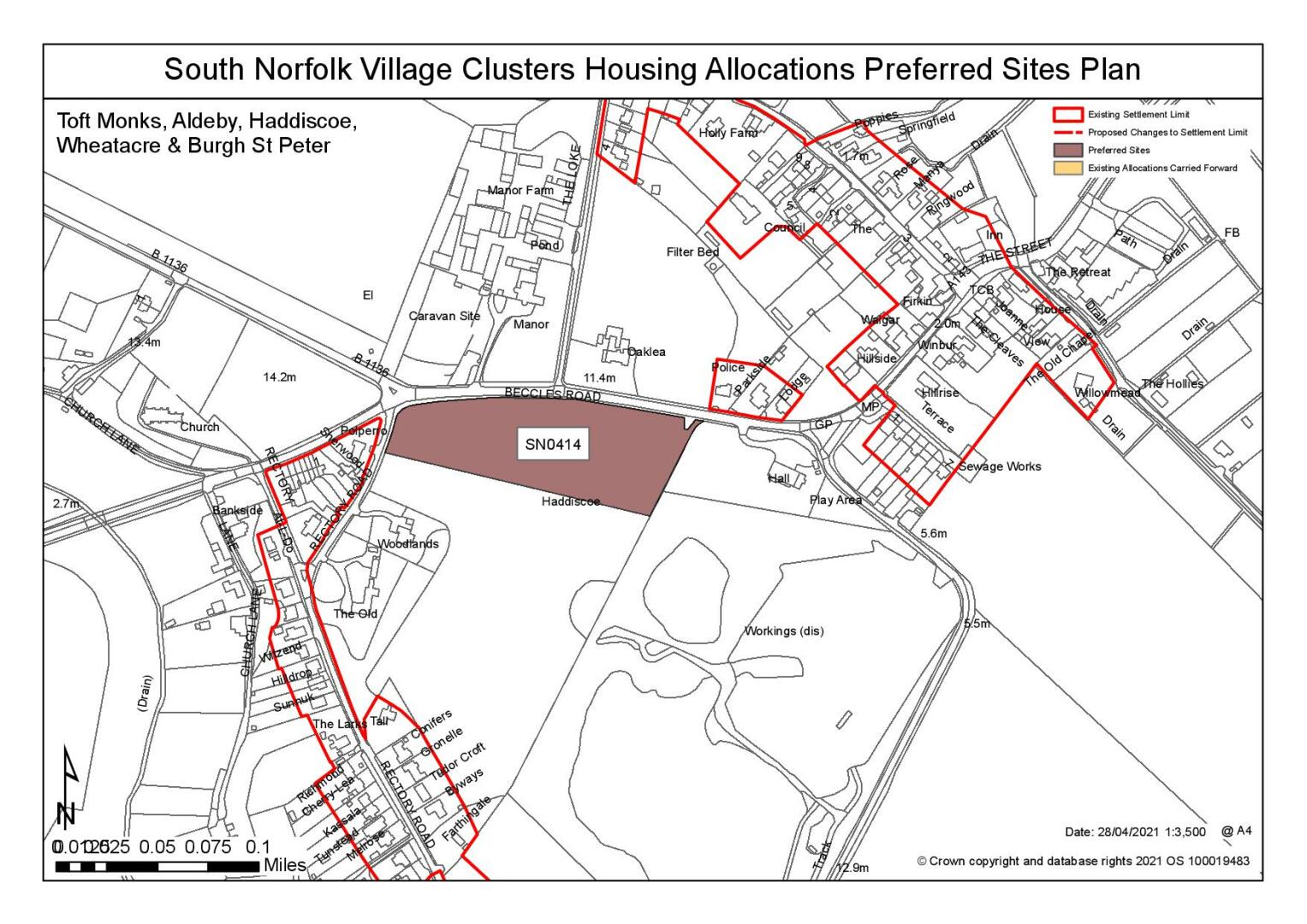
Site: (Part of) SN0414, Land south of Beccles Road, Haddiscoe |
|
Preferred for up to 25 dwellings on a site of 1.2 hectares Reasoned justification: The site is much larger than the scale of development currently being sought, however a smaller parcel could be a reasonable allocation for development, subject to achieving a suitable access and mitigation for landscape and heritage harm. All three sites front the A143, a Corridor of Movement. Whilst the north eastern site has The Lock running to the west this is a narrow and constrained access which is not considered to be an acceptable access point. An existing footpath runs to the northern side of the A143 whilst development of the southern parcel could allow for a new footway on this side of the road and a better located crossing point for the school. Development could have an impact on the setting of the Grade I listed Church and it is noted that on approach from the west the Church is a prominent feature in this rural landscape setting. Given the site size however, potential mitigation measures could be incorporated into the layout and design of the site include setting the buildings further back within the site. An indicative plan would need to demonstrate how the impact of development on these views could be appropriately mitigated. |
|
|
(12) QUESTION 149: Do you support or object to the allocation of the preferred site? Please add additional comments to explain your response and please specify which site(s) you are referring to. If the site is allocated do you think there are any specific requirements that should be set out in the allocation policy?
|
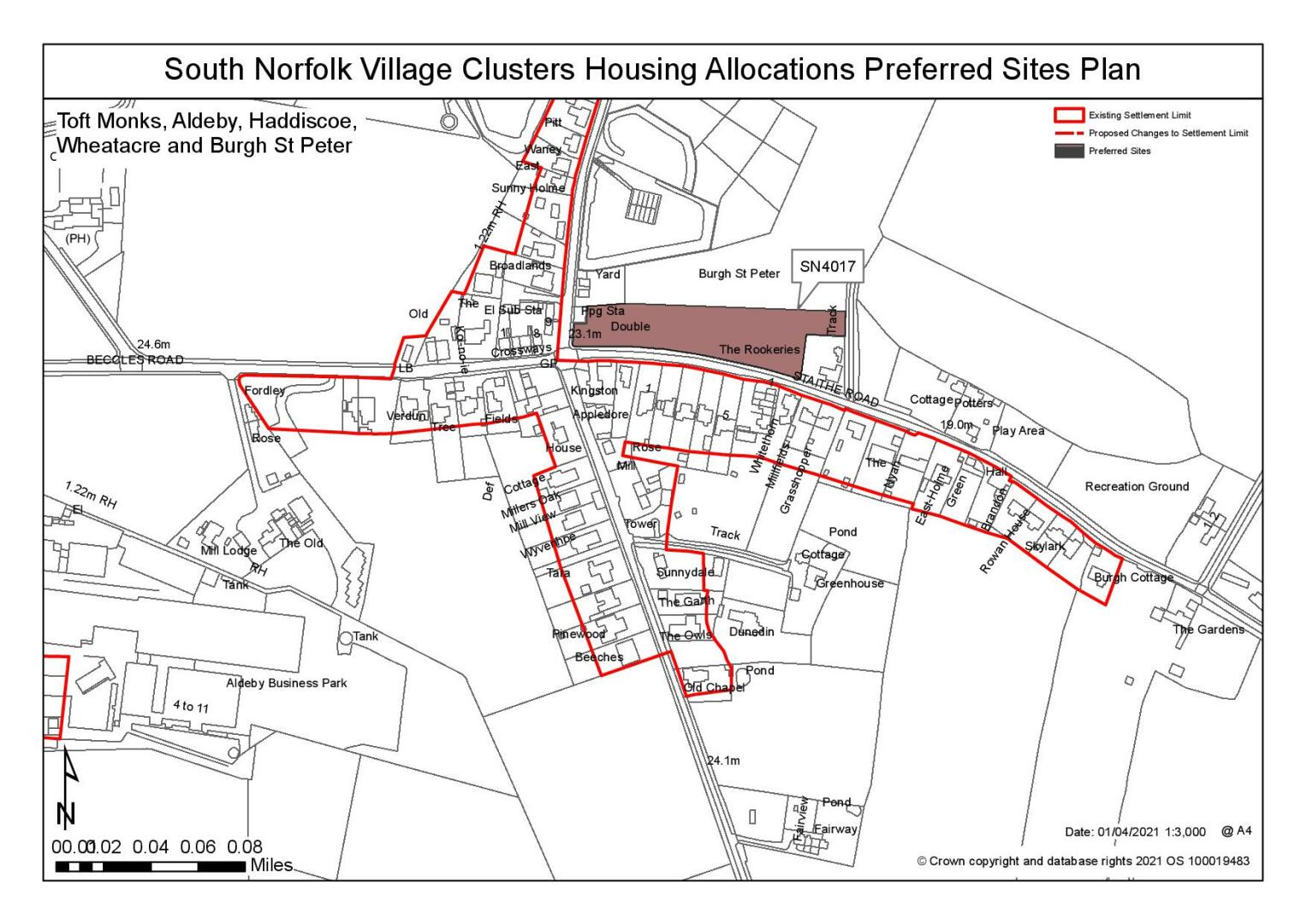
Site: SN4017, Land north of Staithe Road, Burgh St Peter |
|
Preferred for up to 12 dwellings on a site of 0.64 hectares Reasoned justification: Access to the site can be achieved via Staithe Road however there is an existing hedgerow that may require removal to achieve adequate visibility and the hedgerow will need to be assessed in accordance with the hedgerow regulations. It is noted that Highways concerns have been raised about the lack of footways and safe walking route to the local primary school and that local services are limited. However, the site is relatively well contained within the existing pattern of development within the settlement and although development of the site would represent a breakout into the countryside to the north of Staithe Road, it is considered that townscape and landscape impacts could be mitigated. It is noted that overhead power cables run east to west across the site and there is an area of surface water flood risk adjacent to the south west corner of the site. |
|
|
(15) QUESTION 150: Do you support or object to the allocation of the preferred site? Please add additional comments to explain your response and please specify which site(s) you are referring to. If the site is allocated do you think there are any specific requirements that should be set out in the allocation policy?
|
Site: SN4015SL, Land west of Mill Road, Burgh St Peter |
|
Preferred for a Settlement Limit Extension on a site of 0.18 hectares. Reasoned justification: The site is located to the south of the existing Settlement Limit and is considered to be a reasonable option for a settlement limit extension. Development would need to be subject to achieving a satisfactory access, which may result in the loss of hedgerows and this would need to be addressed prior to development. Development on this site would need to respect the linear pattern of existing development to the north, thereby reducing the overall number of units achievable on the site. |
|
|

(6) QUESTION 151: Do you support or object to the proposed use of the site? Please explain your reasons.
Rejected Sites
The following site(s) were promoted for development but have been rejected on the basis of information available at the time of assessment.
|
Site
|
Location and Reasons for Rejection |
|
SN0014SL |
Land to the east of Rushley, Station Road, Aldeby Whilst the site is situated in-between a smaller group of dwellings along Station Road, it is separated from the main village and the surrounding local services and facilities, an issue exacerbated by the lack of local footways. The site is also heavily constrained by dense tree cover and hedging along all boundaries which would require removal and result in a negative landscape impact. Whilst the site doesn't currently appear to be agricultural rotation, the Agricultural Land Classification (ALC) for the site is Grade 2, which is very good quality agricultural land with minor limitations. |
|
SN0392 |
Land at the junction of the A146 and B1136, Haddiscoe The site is located immediately adjacent to the Grade I listed St Mary's Church which also has an associated Grade II monument and memorial. Development of the site would result in harm to the setting of the Church, due to its position within a relatively open landscape. Development of the site would have a poor relationship with the existing pattern of development in evidence. It is unlikely that the required access visibility splays can be achieved without removal of large sections of the frontage hedgerow. |
|
SN0518 |
Land at the post office and Beccles Road, Toft Monks The wider site is significantly too large in the context of this Plan document and no smaller parcels of the site are considered to be suitable for development due to the issues relating to access into the site. Access directly onto the A143 is considered to be unacceptable in highways terms and access onto Post Office Road to the north would require substantial road upgrades and the significant removal of an existing hedgerow. Highway safety concerns include increased slowing, stopping and turning movements at Post Office Road/ A143 junction where visibility is restricted. Although parts of the site are within close proximity to some local services and facilities, actual accessibility to these is much more limited due to the constraints of the local highway network. |
|
SN1031 |
Land to the south / east of Bulls Green Lane, Toft Monks The site is considered to be unreasonable due to identified highway and access constraints. Access to the site would require road widening of Bull Green Lane and the removal of hedgerows. Bulls Green Lane is of narrow, single carriageway width with no footways and limited visibility and it has been concluded that there is no realistic possibility of creating an appropriate access into the site. Additionally, the surrounding highways network is considered to be substandard, including the junction with the A143. Landscape constraints have also been identified; whilst there is relatively new planting to the south-east and south-west, along the eastern boundary is a protected tree belt which would require further arboricultural investigation. |
|
SN2005SL |
Land off Bulls Green Lane, Toft Monks Identified highway and access constraints preclude inclusion of the site as a settlement limit extension. Access to the site would require road widening of Bull Green Lane and the removal of hedgerows. Bulls Green Lane is of narrow, single carriageway width with no footways and limited visibility and it has been concluded that there is no realistic possibility of creating an appropriate access into the site. Additionally, the surrounding highways network is considered to be substandard. |
|
SN4003 |
Land to the east of Common Road, Aldeby Whilst parts of the site are in close proximity to some local services and facilities, actual accessibility to these is much more limited due to the constraints of the local highway network. Areas within the site are also affected by surface water flood risk, including on the highway and to the northern boundary. Development of this site would not respect the linear pattern of existing development in evidence. |
|
SN4010 |
Land to the south of Beccles Road, Burgh St Peter Development of this site would result in backland development, out of character with the existing linear settlement pattern and requiring a convoluted access arrangement which could result in amenity issues for existing residents. Highways concerns about the suitability of the local road network and the lack of footpath provision have also been raised. |
|
SN4014 |
Land to east of Common Road and south of Beccles Road, Burgh St Peter The site is heavily constrained by mature tree cover which has been identified as 'Priority Habitat – Deciduous Woodland'. Loss of part of this woodland would lead to its fragmentation. The site is also at the limits of accessibility to services in terms of an acceptable distance, and this is exacerbated by the lack of footways. Development of the site would need to respect the linear pattern of existing development in evidence in order to avoid an urbanising effect in this location. This would restrict development of the site to frontage development only where there is limited developable land due to the existing tree cover and identified surface water flood risk. |
|
SN4016 |
Land to the east of Mill Road, Burgh St Peter The site is located off Mill Road which is both narrow and restricted. The site is also at the limits of accessibility to services in terms of an acceptable distance, and this is exacerbated by the lack of footways. Development of the site would need to respect the linear pattern of existing development in evidence in order to avoid an urbanising effect in this location. This would restrict development of the site to frontage development only |
(12) QUESTION 152: Do you think that any of the rejected sites should be allocated instead of, or in addition to, the preferred site? Please add additional comments to explain your response and please specify which site(s) you are referring to.
To find out more about the Village Clusters Housing Allocations Plan, please visit our Virtual Exhibition.