
South Norfolk Village Clusters Housing Allocations Plan (Reg. 18 Draft)
13. Ditchingham, Broome, Hedenham and Thwaite
Form and character
Ditchingham
Development within the parish has been concentrated along Loddon Road, Norwich Road, Station Road and Thwaite Road to form the established village of Ditchingham. Abutting the village to the east is the village of Broome. To the south of the parish at Ditchingham Dam is a small area of development which is contiguous with the built-up area of Bungay lying largely within the Broads Authority area and includes the large development on the former maltings sites. Development within the remainder of the parish comprises of individual dwellings and farmsteads.
The village has developed a nucleated settlement form largely as a result of substantial post-war development. The majority of this growth has taken the form of estate development between Thwaite Road and Loddon Road. An area of 1950s Tayler and Green housing at Windmill Green and Scudamore Place makes a significant contribution to the character of the village and is now a Conservation Area. The A143 runs across the south of the parish linking with Beccles and the A146 to the east and Harleston, the A140 and Diss to the west. The B1332 provides a link to Norwich, whilst local road and pedestrian facilities provide easy access to Bungay.
A large area of the southern part of the parish lies within the Broads Authority area with the main village also close to the Broads.
Broome
Development within the parish has been along Yarmouth Road and Sun Road in a linear form with an isolated group of development at Broome Street. Elsewhere the parish displays a dispersed settlement pattern comprising individual dwellings and farmsteads. The south-western end of the village merges with development at Ditchingham so that there is no clear distinction between the two settlements at this point.
The village is set in attractive open countryside within the Waveney Valley. Broome Heath lies to the north of Yarmouth Road and the undeveloped nature of this side of Yarmouth Road provides an open aspect which contributes significantly towards the rural character of the village. The A143, which by-passes the village, provides a link to Harleston and Diss to the south-west and Beccles and Great Yarmouth to the north-east, as well as Lowestoft via the A146. Local road and pedestrian links provide easy access to Bungay to the south, whilst the nearby B1332 provides a link to Norwich to the north.
Part of the parish lies within the Broads Authority area.
Hedenham
Hedenham is a sparsely populated parish. It mainly comprises individual dwellings and farms with a small concentration of development on Church Road. The settlement is set in attractive open countryside interspersed with small wooded areas and is partly situated on the south slope of a small valley bounded to the east by Hedenham Park giving a rural character. The settlement is characterised by traditional cottages with some Tayler and Green housing at Smiths Knoll and both Hedenham Hall and Ditchingham Hall with their associated parklands form an attractive area of historic parkland.
Hedenham has had a designated Conservation Area since 1994.
Thwaite
The main concentration of development within the parish has taken place along Bungay Road towards the church. Individual dwellings and farmsteads are sparsely distributed throughout the remainder of the parish. The agricultural nature and the open countryside all emphasis the rural character of the area.
Services and Community Facilities
The cluster has a range of social, recreational and community facilities including preschool, a primary school, village hall, pub and shop. There is also a regular bus service in Ditchingham. The settlement is also home to several employment uses across different sectors.
Settlement Limit and Constraints
Ditchingham
The Settlement Limit has been drawn to include the main built form of the settlement and include the allocated land to the north of Rider Haggard Way.
The existing primary school in Ditchingham is noted as operating at capacity. However, the nearest alternative school in Ellingham has capacity. Further exploration will be needed to ensure primary school needs can be met.
Broome
The Settlement Limit has been drawn to include the existing linear pattern of development in the settlement and to include the existing allocation made within the 2016 Site Allocations Plan, where outline consent has been granted for 25 dwellings which reflects this linear pattern.
Hedenham
The Settlement Limit has been drawn around the area of Smiths Knoll to allow for limited sensitive infill only due to the limited facilities available and character of the conservation area.
No alterations are proposed to the existing settlement limits within this cluster.
(2) QUESTION 46: Do you agree with the extent of the Settlement Limit and any changes proposed? If not, please explain what further changes should be made.
Preferred and Shortlisted Sites
12 sites have been promoted for consideration, of which 2 have been identified as preferred allocation site and a further 2 have been shortlisted.
Preferred Sites
On the basis of the assessment undertaken the following site(s) have been identified as a preferred allocation:
|
Site: SN0373, Land between Thwaite Road and Tunneys Lane |
|
Preferred for up to 35 dwellings on a site of 1.4 hectares. Reasoned justification: The site as promoted is significantly larger than the preferred site and could potentially accommodate more than 35 dwellings if necessary. The site is well related to the existing services and facilities within Ditchingham. No additional constraints have been identified which would affect its delivery. Although, the development of the site is subject to suitable access via the current DIT1 allocation (which has yet to be started) and Waveney Road, and this may limit the total capacity for the site to expand. The preferred site at approx. 1.4ha reflects the aspirations for the plan and would be located to the south east of the site. |
|
|
.jpg)
(7) QUESTION 47: Do you support or object to the allocation of the preferred site? Please add additional comments to explain your response and please specify which site(s) you are referring to. If the site is allocated do you think there are any specific requirements that should be set out in the allocation policy?
|
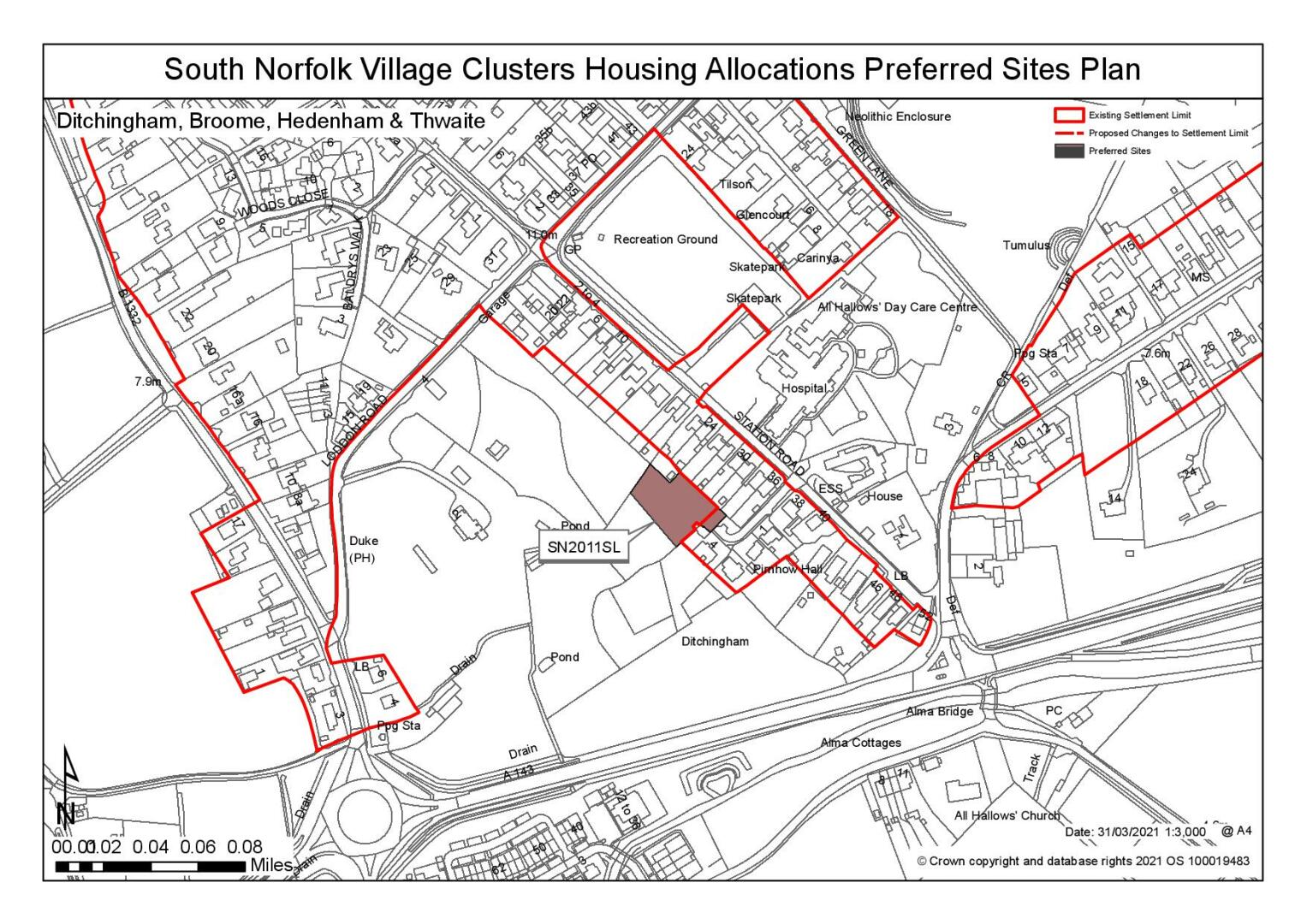
Site: SN2011SL, Land off Lamberts Way, Ditchingham |
|
Preferred for a Settlement Limit Extension on a site of 0.4 hectares. Reasoned justification: The site is suitable for a Settlement Limit extension. The site would be accessible from Lamberts Way and is adjacent to residential development to the south and the east. The promoter has noted that they would wish to build one self-build dwelling on the site although the site is a sufficient size to potentially allow a larger number of properties. |
|
|
(8) QUESTION 48: Do you support or object to the proposed use of the site? Please explain your reasons
Shortlisted Sites
On the basis of the assessment undertaken the following site(s) have been shortlisted:
|
Site
|
Location and Reasons not preferred for allocation: |
|
SN0345 |
Land to the north of Loddon Road, Ditchingham Shortlisted for up to 25 dwellings on a site of 1.62 hectares. This site is considered to suitable for allocation, subject to confirmation of highway suitability, provision of a footway and confirmation that the development of the site would not have an unacceptable impact on the nearby SSSI. The site relates suitably to existing services and facilities, the existing form and character of the village and there is limited impact on the wider landscape due to existing screening. |
|
SN4020 |
Land west of Old Yarmouth Road, Broome Shortlisted for up to 15 dwellings on a site of 0.67 hectare. (Note: The western part of this site overlaps with SN4049) The site is considered a reasonable option for additional road frontage development. Consideration should however be given to the continued linear spread of the village to the east away from the main services and facilities |
Rejected Sites
The following site(s) were promoted for development but have been rejected on the basis of information available at the time of assessment.
|
Site
|
Location and Reasons for Rejection |
|
SN0078 |
Land off Loddon Road, Ditchingham The development of the site would require the removal of a number of trees. Development would impact upon the landscape. Furthermore, the site is in multiple ownership and it is unclear if all the site owners support development. |
|
SN0205SL |
Land north west of Scudamore Place, Ditchingham The site is located within the setting of the Taylor and Green properties at Scudamore Place. Development would impact upon the setting of these dwellings which are grade II listed. It would also impact upon the setting of the exception site with the dwellings located directly in front of them. Development of the site would impact upon the amenity of these properties by virtue of their close proximity. For this reason the site was rated red through the HELAA for townscape impacts and has been excluded from the site assessments. |
|
SN0343 |
Land adjoining Wildflower Way, Ditchingham The development of the site would represent an extension into open countryside with limited screening to reduce impact. This is considered to have a detrimental impact upon the form and character of the settlement and landscape overall. |
|
SN0346 |
Land to the north of Old Yarmouth Road, Broome Whilst the site is well located within Broome with good access to services and facilities, it is a designated Local Nature Reserve. The site also forms part of the setting of Broome Heath which is a County Wildlife Site, with access to the rear of the site. Development in this location is considered to have an impact upon the landscape and ecology and it is not considered to be a reasonable option |
|
SN3004SL |
Land to the south of 130 Yarmouth Rd, Broome The new dwelling would be located directly to the rear of the existing property 130 Yarmouth Road. The proposal is considered to be detrimental to the townscape, furthermore amenity issues have also been identified for 130 and 128 Yarmouth Road as the access will pass directly between the two dwellings the site is not considered a reasonable option for an extension to the Settlement Limit. |
|
SN4021 |
Land to the south east of Loddon Road, Broome Development of the site is considered to result in a detrimental impact upon the townscape and also the satisfactory functioning of the highway. |
|
SN4044SL |
Land to the rear of 126 Yarmouth road, Broome The new dwelling would be located directly to the rear of the existing property 130 Yarmouth Road. The proposal is considered to be detrimental to the townscape, furthermore amenity issues have also been identified for 130 and 128 Yarmouth Road as the access will pass directly between the two dwellings the site is not considered a reasonable option for an extension to the Settlement Limit. |
|
SN0410REV |
Land west of Old Yarmouth Road, Broome The site is on edge of village, but key services and facilities are accessible via a footpath connection to the village. Site is in a gateway location and development to the rear of other dwellings would be highly visible within the landscape. |
(9) QUESTION 49: Do you think that any of the shortlisted or rejected sites should be allocated instead of, or in addition to, the preferred site(s)? Please add additional comments to explain your response and please specify which site(s) you are referring to.
(3) QUESTION 50: Do you think that any of the shortlisted site(s) should be rejected? Please add additional comments to explain your response and please specify which site(s) you are referring to.
To find out more about the Village Clusters Housing Allocations Plan, please visit our Virtual Exhibition.