
South Norfolk Village Clusters Housing Allocations Plan (Reg. 18 Draft)
39. Tharston, Hapton and Flordon
Form and character
Tharston and Hapton
There are three main groups of development within the parish concentrated on The Street (Tharston), Chequers Road adjoining Long Stratton and in Hapton. Outside of these there are some isolated areas of sporadic development. The western edge of the parish adjoins the Tas Valley.
Development in The Street incorporates a variety of dwelling types alongside farms. This combined with substantial tree and hedge planting, especially along the road frontage gives the settlement its strong rural character.
In the south of the parish are housing estates off Chequers Road which are contiguous with Long Stratton, and towards the northern end of Chequers Road a broken ribbon of development. This ribbon is rural in character.
Hapton is a small settlement which has developed along the line of the B1135, The Street. Some development has occurred to the north of this and the settlement has experienced limited modern infill development.
Flordon
The settlement of Flordon comprises two physically distinct areas. One is situated around the main Norwich-London railway line bridge, and the other has developed further to the west around the parish church. The village has experienced limited estate scale housing development in the form of a small housing estate (St Michaels View) together with some more recent infill development.
The village is characterised by good tree and hedge planting together with significant open frontages which contribute towards its rural setting. To the south of The Street is a tributary valley of the River Tas which includes Flordon Common, an SSSI.
Services and Community Facilities
The cluster has limited facilities. There is a primary school, with some areas for recreation and employment and a limited bus service.
Settlement Limit and Constraints
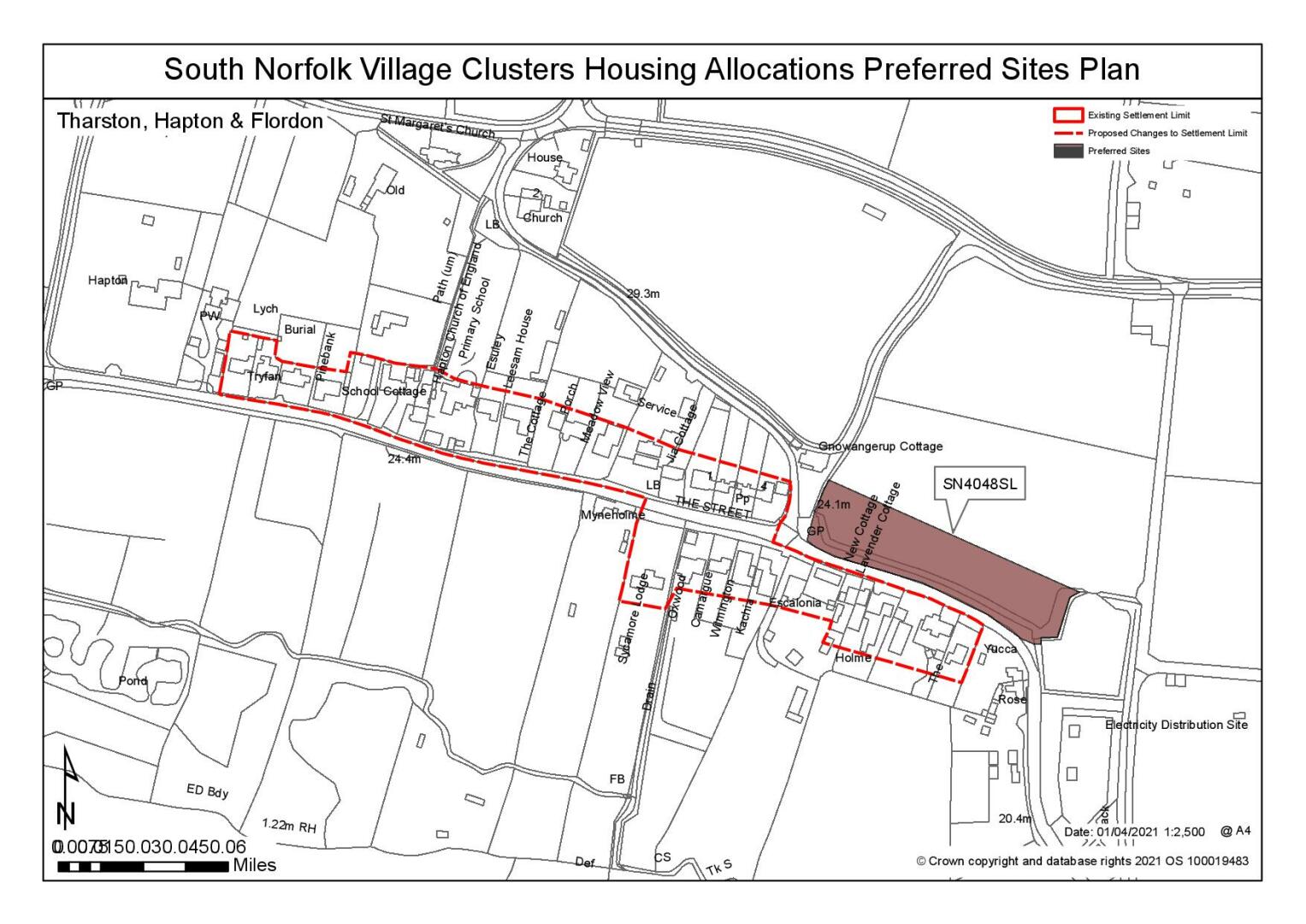
Hapton
A new Settlement Limit has been drawn to include the main area of linear development to the north of the B1135. This would be extended to include the proposed allocation site should it be included in the final version of the plan. The Settlement Limit also extends to the south of the B1135 to the east of the settlement. These changes are shown on the policies map.
Flordon
The Settlement Limit is fragmented and drawn to include the estate development at St Michael's View to the west and the groups of dwellings either side of the rail track to the east. It excludes the Rectory, church room and a few dwellings on the south of The Street.
(2) QUESTION 135: Do you agree with the extent of the Settlement Limit and any changes proposed? If not, please explain what further changes should be made.
Preferred and Shortlisted Sites
5 sites have been promoted for consideration, of which 1 has been identified as a preferred allocation site.
Preferred Sites
On the basis of the assessment undertaken the following site has been identified as a preferred allocation:
|
Site: SN4048, Land to the north of The Street, Hapton |
|
Preferred for up to 12 dwellings on a site of 0.48 hectares Reasoned justification: The site was originally proposed as a Settlement Limit Extension. However, it is only under the 0.5ha threshold and therefore considered to have potential to accommodate allocation scale growth.The allocation of the site will require the creation of a new Settlement Limit for Hapton.The site is reasonably well connected and related to the main settlement, including the primary school where there is an existing footpath from the site to the school. The site is considered as an appropriate location for linear development, subject to creating a safe access which addresses the significant change of level from the site to the highway. Whilst heritage assets (listed buildings) have been identified, it has been acknowledged that they are at a distance where their setting would not be affected by development. There are few constraints. |
|
|
(27) QUESTION 136: Do you support or object to the allocation of the preferred site? Please add additional comments to explain your response and please specify which site(s) you are referring to. If the site is allocated do you think there are any specific requirements that should be set out in the allocation policy?
Rejected Sites
The following site(s) were promoted for development but have been rejected on the basis of information available at the time of assessment.
|
Site |
Location and Reasons for Rejection |
|
SN0255 |
The Laurels, Land north of The Street Development of the site would represent backland development that would have a poor relationship with existing development. Whilst there is an existing access, The Street does not appear suitable for additional traffic nor can an adequate visibility splay be provided due to the limited site frontage. It is not considered possible to create a safe access to the site and it is also noted that there is no footpath provision for the entirety of Tharston. Development in this location would also have an impact on the listed buildings located within proximity of the site. |
|
SN0566 |
Land north of The Street, Flordon Flordon has limited services and accessibility to services elsewhere is very limited. Although the site benefits from a new footpath to the south, this footpath stops to the north of the village and therefore there is no potential safe walking route to the Primary School in Hapton. There are also landscape and heritage concerns; St Michaels Church (Grade I LB) is located to the north east corner of the site. |
|
SN1051 |
Land at The Street, Tharston The site is considered to be an unreasonable extension to the existing settlement limit due to highway concerns. Access to the site would require localised carriageway widening to 5.5m, 2m wide frontage footway and removal of existing frontage trees (these trees may have TPOs). However, the local road network is restricted in width and lacks a footway provision. There is no continuous footway to catchment primary school (the catchment school is Manor Field in Long Stratton rather than Hapton). Heritage impacts have also been identified, however the impact of development on the setting of the LB (Church Farm Cottage) could be reasonably mitigated. |
|
SN2147 |
Land East of Greenways, Flordon The site is considered to be unsuitable for allocation due to its physical separation from the main settlement, access issues and the adverse impact development would have on the townscape. Whilst an extension of the existing footpath could be created it would require the use of land which is either highway verge or in third party land ownership. It would also require total removal of hedge and trees along the site frontage. Greenway is narrow with no footway and visibility at its junction with Station Road is limited by a bridge. The site is also detached from the village and the existing residential dwellings to the south. |
(4) QUESTION 137: Do you think that any of the rejected sites should be allocated instead of, or in addition to, the preferred site? Please add additional comments to explain your response and please specify which site(s) you are referring to.
To find out more about the Village Clusters Housing Allocations Plan, please visit our Virtual Exhibition.