
South Norfolk Village Clusters Housing Allocations Plan (Reg. 18 Draft)
37. Tacolneston and Forncett End
Form and character
The main concentration of development within the parish of Tacolneston is based along Norwich Road and adjoins the built-up area of Forncett End to the south. Development in the remainder of the parish comprises scattered individual dwellings and farmsteads. The village developed as a predominantly linear settlement along Norwich Road with the addition of post war estate development, namely at Dovedale Road, Boileau Avenue and off Bentley Road in Forncett End.
Further estate development exists at The Fields to the west of Norwich Road. A significant break in the built-up frontage on both sides of Norwich Road exists to the north of the Manor House buildings whose setting in spacious grounds with good tree growth contributes towards the 'open' nature and rural character of this part of the village. The area to the north of the estate development at Dovedale Road is designated as a Conservation Area, which extends as far east as the church. This area has a distinctly rural character with mature trees.
In Forncett End a ribbon of development has extended along Long Stratton Road to the east with development limited to the north side of the road east of Chestnut Tree Farm with the southern side largely undeveloped and fronting open fields. Development has also extended along the south side of West Road and along both sides of Tabernacle Lane as far as Elm Tree Farm.
The B1113 provides relatively good access to Norwich and New Buckenham whilst the B1135 runs to the north providing access to Wymondham and Long Stratton. The remainder of the parish is served by 'C' class and unclassified roads.
Services and Community Facilities
The parish has a range of social and community facilities including a preschool, primary school, pub, village hall and recreation facilities. There is also a limited bus service.
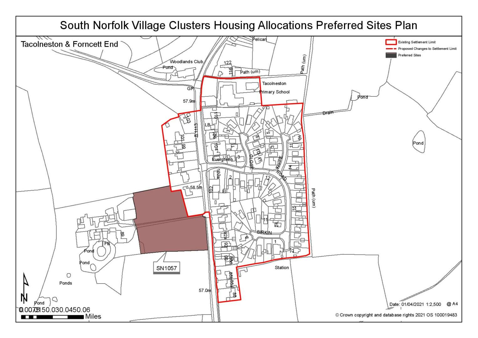
Settlement Limit and Constraints
Tacolneston has two separate areas contained within settlement limits. A Settlement Limit has been drawn to include the main built form of the settlement whilst a smaller Settlement Limit has been drawn around the estate development at Dovedale Road to the north of the village. No alterations are proposed to the existing Settlement Limit.
(3) QUESTION 128: Do you agree with the extent of the Settlement Limit and any changes proposed? If not, please explain what further changes should be made.
Preferred and Shortlisted Sites
12 sites have been promoted for consideration, of which 1 was identified as a preferred allocation site and 1 was shortlisted.
Preferred Sites
On the basis of the assessment undertaken the following site(s) have been identified as a preferred allocation:
|
Site: (Part of) SN1057, Land to the west of Norwich Road |
|
Preferred for up to 20 dwellings on a site of 0.7 hectares. Reasoned Justification: The site is larger than typically sought within the Village Cluster Plan but has scope to be reduced in scale in line with the plans overall objectives. The site is within a sustainable location and relates well to existing development to the north of the settlement. Development of the site would be limited to the top section of the site only in order to reduce the landscape and townscape impact of new development in this location. Creation of an adequate access would require the removal of existing vegetation and trees along the site frontage and some additional highways safety works may be required to support the development of this site. The trees at the front of the site are subject to TPOs. Consideration would need to be given to the form of development on this site. |
|
|
(9) QUESTION 129: Do you support or object to the allocation of the preferred site? Please add additional comments to explain your response and please specify which site(s) you are referring to. If the site is allocated do you think there are any specific requirements that should be set out in the allocation policy?
Shortlisted Sites
On the basis of the assessment undertaken the following site(s) have been shortlisted:
|
Site |
Reasons not preferred for allocation: |
|
SN0602 |
Land off The Fields Shortlisted for up to 14 dwellings on a site of 0.55 hectare. The site is adjacent to the settlement limits and an extant residential permission. It is well related to existing residential development and would have a limited impact of the landscape as it is contained by a western and southern boundary line. It could come forward as a comprehensive scheme with the existing allocation. Access should be from The Fields to the north, via the extant permission. |
Rejected Sites
The following site(s) were promoted for development but have been rejected on the basis of information available at the time of assessment.
|
Site |
Location and Reasons for Rejection |
|
SN0016SL REV |
Land to the rear of 122 Norwich Road The site is an unreasonable site for both allocation and extension to the settlement limit because development would impact on the setting and significance of the Listed Buildings and Conservation Area. The traditional verdant setting of the group of dwellings at number 116 and 122 Norwich Road will not be preserved as a result of the reduction in the size of the curtilage at number 122. It is unlikely that satisfactory visibility could be provided at access, particularly to on-coming traffic and footway improvement to min 2.0m width would be required between site and school. Any removal of hedging to achieve highway requirements would be detrimental to the heritage assets. |
|
SN0084 |
Horse Meadow, Talconeston As promoted the site is excessive scale in scale but it could be reduced in size. Development of the site would represent a significant break out to the east of Tacolneston which would be detrimental to the landscape and townscape. In addition, there is no continuous footway to catchment school and access from Chenery lane is not considered to be suitable as it is unclear if access can be achieved from the Poplars. It would require carriageway widening to 5.5m, a frontage footway and removal of existing hedges which would have a negative impact on the landscape. |
|
SN0086 |
Land north of Common Road The site is unreasonable for allocation by virtue of its separation from the existing built form. Development would be an encroachment into the countryside and would have a detrimental impact on the landscape and townscape. Access could be achievable at Common Rd but given the narrow width of the road it would require carriageway widening to 5.5m min and a 2.0m footway. This would require the removal of frontage hedge/trees which would further impact on the landscape. It is not feasible to provide a footway to catchment school due to constraint in vicinity of Common Road/Norwich Road junction. There is also the possibility of surface water flooding as there is a small area of ponding in the southeast but it is unlikely to prevent development. |
|
SN0089 |
Land south of Common Road Development of the site is unreasonable as it would be a significant breakout to the south of the existing village. The site is excessive in scale but could be reduced in size however development on this site would be detrimental to the landscape and townscape. Furthermore, access is likely to require removal of frontage hedge/trees. It is not feasible to provide footway to catchment school due to constraint in vicinity of Common Road/Norwich Road junction. |
|
SN0094 |
Land north of Norwich Road The site is unreasonable for allocation as development would be an encroachment into the countryside and have a detrimental impact on the landscape and townscape. Access could be achievable at Common Rd but given the narrow width of the road it would require carriageway widening to 5.5m min and a 2.0m footway. This would require the removal of frontage hedge/trees which would further impact on the landscape. It is not feasible to provide a footway to catchment school due to constraint in vicinity of Common Road/Norwich Road junction. There is the possibility of surface water flooding as there is a small area of ponding in the south-east but it is unlikely to prevent development. |
|
SN2013 |
Land at Black Barn The site is considered to be unreasonable as both an extension to the settlement limit and an allocation. The site is detached from the existing built form and would represent a breakout, which does not reflect the existing townscape. The access and local road network along Tabernacle Lane is not considered to be suitable for increased traffic by virtue of its restricted width and lack of footpaths and passing places. Highways officers have advised that is unlikely to be possible to provide acceptable access visibility due to the limited frontage as well as the adjacent hedge/narrow carriageway. Development of the site would negatively impact on the setting of the designated heritage assets and it is not considered that the benefits of the proposal would outweigh this harm. |
|
SN2031 |
Land east of Norwich Road Whilst the site relates well to the existing settlement limit development in this location would have a negative impact on the landscape. It would require the loss of significant trees and hedgerow which create the rural character of this part of Tacolneston and form a significant green break between two parts of the village. There are forward visibility issues to the south along the bend and a surface water flow path runs along the south of the site. These constraints significantly reduce the developable site area. |
|
SN4019 |
Land to the south of Hall Road The site is an unreasonable site for allocation due to the detrimental impacts on the landscape and townscape. Development of the site would be a significant extension into the countryside which would not reflect the exiting form of the settlement on this side of Norwich Road. It would negatively impact on the adjacent Conservation Area and Woodland TPO. Access is also not considered to be suitable as Hall Road is substandard, there is no safe walking route and visibility splays would require the removal of important countryside trees/hedging. |
|
SN4061SL |
The Pelican, 136 Norwich Road, Talconeston The site is unreasonable as an extension to the settlement limit as it would not reflect the existing form and character of the immediate area and would result in harm to the historic environment. New dwellings in this location will contribute towards eroding the open space behind the properties on Norwich Road and will cause harm to the character and appearance of the conservation area and impact on the Grade II listed Pelican PH. It would require improvement to existing footway to 2.0m between site and school and visibility splays which would also have a negative impact on the historic environment. There is surface water flooding although it is unlikely to prevent development. |
|
SN4062SL |
The Pelican, 136 Norwich Road, Talconeston Development of the site would be to the rear of numbers 126 to 134 Norwich Road and The Pelican public house which would not reflect the existing form and character. This will result in harm to the historic environment because it is located within the Conservation Area and would impact on The Pelican PH which is Grade II listed. It would require improvement to existing footway to 2.0m between site and school and visibility splays which would also have a negative impact on the historic environment. |
(6) QUESTION 130: Do you think that any of the shortlisted or rejected sites should be allocated instead of, or in addition to, the preferred site? Please add additional comments to explain your response and please specify which site(s) you are referring to.
(1) QUESTION 131: Do you think that any of the shortlisted sites should be rejected? Please add additional comments to explain your response and please specify which site(s) you are referring to.
To find out more about the Village Clusters Housing Allocations Plan, please visit our Virtual Exhibition.