
South Norfolk Village Clusters Housing Allocations Plan (Reg. 18 Draft)
6. Bawburgh
Form and character
Bawburgh is situated in the bottom of the Yare Valley between the B1108 and A47. Two distinct settlement groups have developed each side of the river. To the south of the river, frontage development extends along Church Street towards the church; more recent estate development is situated on Hockering Lane, with a detached group of dwellings further south beyond the village hall on Stocks Hill. To the north of the river, frontage development follows the line of New Road and Harts Lane, with another nucleus of dwellings to the west of the junction with Marlingford Road.
The central area of the village was designated a Conservation Area in 1973. The floodplain of the River Yare between the two 'sides' of the village has remained undeveloped. This contributes to the valley setting of Bawburgh.
Services and Community Facilities
Bawburgh is situated in the bottom of the Yare Valley between the B1108 and A47. Two distinct settlement groups have developed each side of the river. To the south of the river, frontage development extends along Church Street towards the church; more recent estate development is situated on Hockering Lane, with a detached group of dwellings further south beyond the village hall on Stocks Hill. To the north of the river, frontage development follows the line of New Road and Harts Lane, with another nucleus of dwellings to the west of the junction with Marlingford Road.
The central area of the village was designated a Conservation Area in 1973. The floodplain of the River Yare between the two 'sides' of the village has remained undeveloped. This contributes to the valley setting of Bawburgh.
Settlement Limit and Constraints
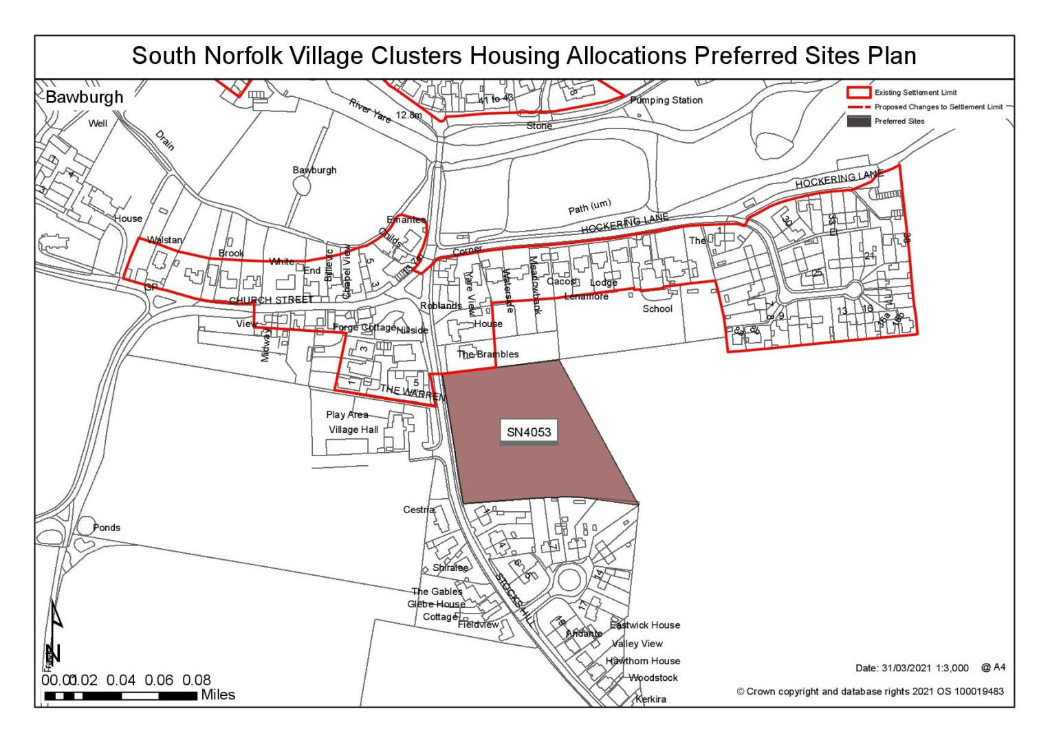
The Settlement Limit is separated by the river which runs through the centre of the village. The northern section includes almost all dwellings on New Road and Harts Lane, including the small cluster of development at the junction with Marlingford Road. The southern section includes most buildings on Church Street and Hockering Lane, but excludes the church itself. The cluster of dwellings at Stocks Hill, south of the village hall, is excluded from the Settlement Limit, as this area contributes to the valley setting and rural entrance to the village. No alterations are proposed to the existing Settlement Limit.
(1) QUESTION 26: Do you agree with the extent of the Settlement Limit and any changes proposed? If not, please explain what further changes should be made.
Preferred and Shortlisted Sites
5 sites have been promoted for consideration, of which 1 has been identified as a preferred allocation site. No further sites were shortlisted.
Preferred Site(s)
On the basis of the assessment undertaken the following site(s) have been identified as a preferred allocation:
|
Site: SN4053, Land to the east of Stocks Hill |
|
Preferred for 35 dwellings on a site of 1.4 hectare. Reasoned justification: The site is well related to the existing built form of the settlement and would benefit from good connectivity to village services. A landscape assessment would be required to determine the landscape impact of development in this location. There would not be a significant impact on existing vegetation on the site. |
|
|
(8) QUESTION 27: Do you support or object to the allocation of the preferred site? Please add additional comments to explain your response and please specify which site(s) you are referring to. If the site is allocated do you think there are any specific requirements that should be set out in the allocation policy?
Rejected Sites
The following site(s) were promoted for development but have been rejected on the basis of information available at the time of assessment.
|
Site |
Location and Reasons for Rejection |
|
SN4071 |
Land to the east of Harts Lane and South of Long Lane. Development of the site would have a negative impact upon both the landscape and townscape, particularly having regard to the site's location at a gateway into Bawburgh from the east. Development of the site would also require the removal of a section of hedgerow to facilitate access and footpaths and significant highways concerns have been raised about the connectivity of the site to the facilities within the village due to the narrow form of the bridge in the village. It is not considered that the constraint could be reasonably addressed. |
|
SN3032 |
Land to the west of Harts Lane. Large portions of the site are within flood zones 2 and 3, restricting the developable area of the site. The site is located within the River Valley and forms a key part of the verdant rural character of the area. Development of the site would impact upon the townscape and landscape. Highways concerns have been raised and development of the site would also require the removal of a significant hedgerow along the front of the site which is a particular feature of the existing streetscene. |
|
SN0015 |
Land at New Road. The site is located outside of the main built form of the village and has poor connectivity to the services and facilities within the village. A number of highways constraints have been identified and the site lies within a number of landscape protection designations. The separation of the site from the main areas of the settlement would increase the detrimental landscape impact of development in this location. |
|
SN0002SL |
Land to the east of the Brambles, Stocks Hill. The site is located to the rear of The Brambles and any development in this location would constitute uncharacteristic backland development. The site also lies within a number of landscape designations, including the Conservation Area. |
(5) QUESTION 28: Do you think that any of the rejected sites should be allocated instead of, or in addition to, the preferred site? Please add additional comments to explain your response and please specify which site(s) you are referring to.
To find out more about the Village Clusters Housing Allocations Plan, please visit our Virtual Exhibition.