
South Norfolk Village Clusters Housing Allocations Plan (Reg. 18 Draft)
23. Little Melton and Great Melton
Form and Character
Little Melton
Little Melton was historically linear in form, but some estate development has taken place at Ringwood Close, Gibbs Close and south of School Lane at Braymeadow and Greenacres. The grounds of Elm Farm, which is centrally located in the village, provides an important break in the street frontage and contributes to the character of the centre of the village. The village is set in open countryside, and is visible from Watton Road to the north, creating a landscape setting when approaching the village from Green Lane. However, hedges and trees to the south of the village mean there are fewer long-range vistas.
The proximity to the A47 (via Green Lane) makes Little Melton accessible from Norwich. There are bus stops (on both sides of the road) at two points in the village, with buses to Wymondham, Hethersett and Norwich.
Great Melton
Great Melton comprises a scattering of farms and cottages with a loose knit group of dwellings at High Green. To the north of High Green there is an area forming Great Melton Park.
Services and Community Facilities
The cluster has a range of services and community facilities including preschool, Little Melton Primary School and the Village Inn, plus a convenience store and MOT garage. There are allotments, accessible from Great Melton Road and Mill Road, which contribute to the rural nature of the village. The village hall and playing field are on Mill Road, outside the Settlement Limit and in a countryside setting. There is a lack of footpaths in the village, which combined with narrow roads, makes pedestrian travel challenging at peak times. There is also a limited bus service.
Settlement Limit and Constraints
The Settlement Limit has been drawn to include the main built form of the settlement and include the land allocated within the 2015 Site Allocations Plan (LIT 1) located south of Ringwood Close. The Settlement Limit maintains to exclude the allotments which run between Great Melton Road and Mill Road. The Settlement Limit has been extended to reflect the recent Reserved Matters application 2015/1697 for 27 residential dwellings. The Settlement Limit will also be amended slightly to reflect recent minor planning permissions on School Lane (16/1105/F and 17/0251/F) These changes are shown on the policies map.
There are problems with surface water drainage, which could be alleviated through improved maintenance of open and piped water courses.
The South Norfolk Place-making Guide states that key views of historic churches should be protected. All Saints' Church lies to the east of the village along Mill Road, separated from the village by agricultural land. From the village, views of the church are blocked by roadside hedges and field boundary hedges.
(14) QUESTION 80: Do you agree with the extent of the Settlement Limit and any changes proposed? If not, please explain what further changes should be made.
Preferred and Shortlisted Sites
12 sites have been promoted for consideration, of which 2 have been preferred for allocation and 2 have been shortlisted.
Preferred Sites
On the basis of the assessment undertaken the following site(s) have been identified as a preferred allocation:
|
Site: SN1046REV, Glenhaven, Great Melton Road, Little Melton |
|
Preferred for a Settlement Limit Extension on a site of 0.69 hectares. Reasoned justification: The site is situated to the rear of residential development on all sides and appears to be landlocked. However, the promoter has advised that the proposal would include the demolition of 'Glenhaven' dwelling to the south to allow access to the site. The Highway Authority have raised concerns with the access and whether a suitable access could be achieved, and the local road network is unsuitable. These concerns would need to be demonstrated prior to development. Whilst the site is of allocation size, development potential is limited given the backland nature of the site, its awkward layout of the site, and the need to demolish the existing bungalow to gain access. Therefore, it is only proposed to bring the site into the Settlement Limit. |
|
|
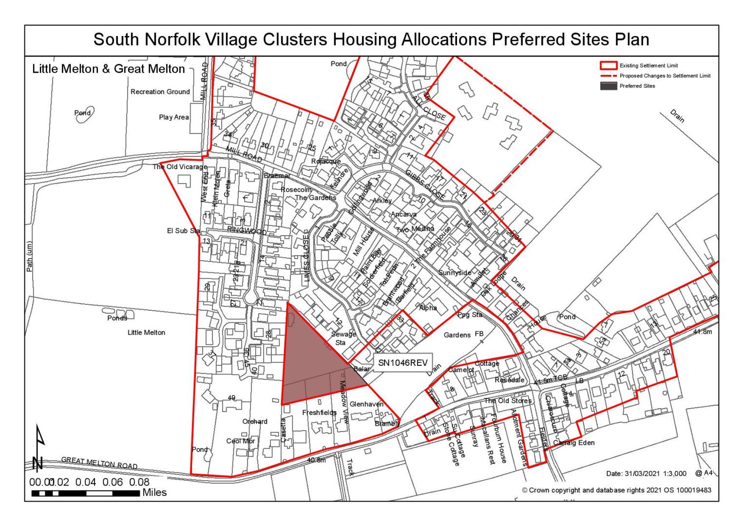
(39) QUESTION 81: Do you support or object to the proposed use of the site? Please explain your reasons
|
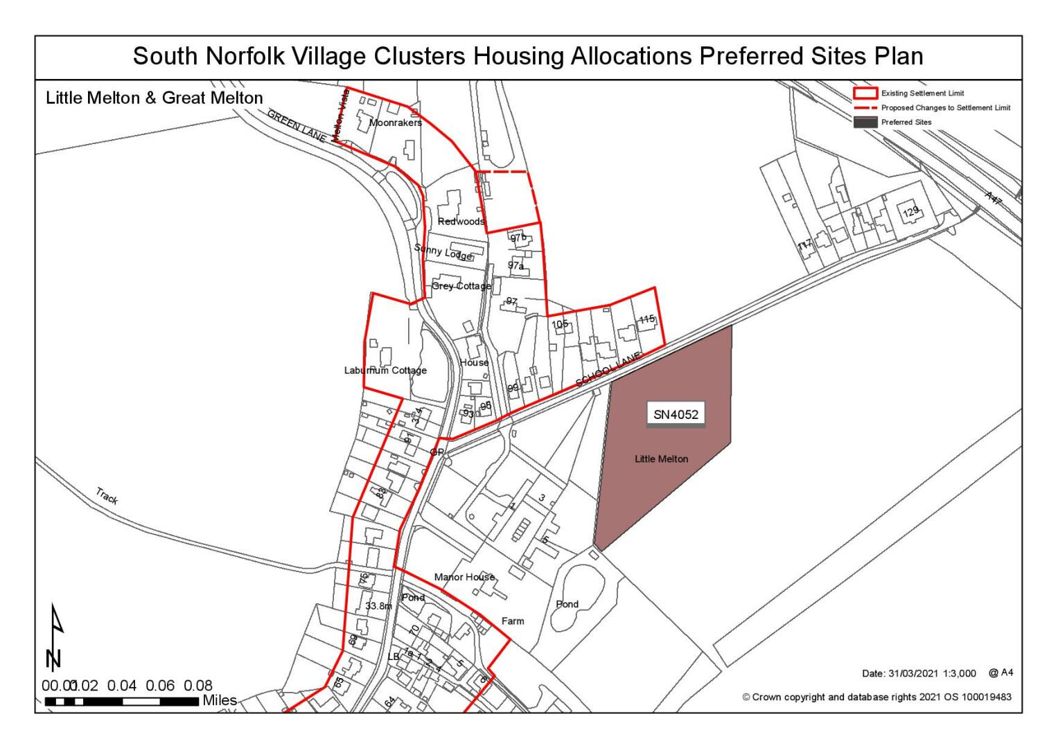
Site: SN4052, Land south of School Lane and east of Manor Farm Barns, Little Melton |
|
Preferred for up to 25 dwellings on a site of 1 hectare. Reasoned justification: Whilst peripheral to the village, the site is reasonable well related to existing services and facilities. The site is located to the south of School Lane where there are reasonable verges but no footways, the road would need to be widened and include footpaths. It would also need to be demonstrated that sufficient visibility splays can be achieved, prior to accepting development is acceptable. Whilst the site is located within a residential context, located to the west is Manor Farm Barns which is considered a non-designated heritage asset, the impact of the setting would need to be considered. In landscape terms, the site is relatively open where the Southern Bypass Landscape Protection Zone seeks to protect openness. The site does not have any significant arboricultural issues. |
|
|
(59) QUESTION 82: Do you support or object to the allocation of the preferred site? Please add additional comments to explain your response and please specify which site(s) you are referring to. If the site is allocated do you think there are any specific requirements that should be set out in the allocation policy?
Shortlisted Sites
On the basis of the assessment undertaken the following site(s) have been shortlisted:
|
Site |
Reasons not preferred for allocation: |
|
SN0488 |
Land north of School Lane (between No115 and No117), Little Melton Shortlisted for up to 25 dwellings on a site of 1 hectare. NCC Highway Authority have raised site access concerns; the site is accessed via School Lane which is a constrained road that would need to be widened and include footpaths. Poor visibility has also been identified and it would need to be demonstrated that adequate visibility at the junction can be achieved, prior to accepting any further development off School Lane. In addition, any loss of hedgerow along the verge would need to be assessed prior to removal. Whilst the site is relatively well screened, the site is also located within the Southern Bypass Landscape Protection Zone where existing local plan policy requirements set to retain openness, any scheme would need to take this into consideration and justify any erosion of this protection zone. Surface Flood has been identified to the site frontage and highway, however it is considered that this could be mitigated. |
|
SN2044 |
Land north of Braymeadow Lane, Little Melton Shortlisted for up to 25 dwellings on a site of 1 hectare. The wider site is significantly too large in the context of the Village Clusters document therefore, subject to a reduction in size and scale of up to 25 dwellings, the site would be considered suitable. The land considered acceptable for development is the land adjoining existing development on Braymeadow and Greenacres to the west. Highway constraints have been identified; access via Braymeadow Lane is narrow and would requirement widening, including the provision of a footway, therefore the site would be subject to achieving satisfactory access. In light of this, it has also been identified that there is significant number of roadside trees in closest proximity to the existing development |
Rejected Sites
The following site(s) were promoted for development but have been considered to be unreasonable alternatives on the basis of information available at the time of assessment.
|
Site |
Location and Reasons for Rejection |
|
SN0182 |
Land north of Mill Road, Little Melton (west of village hall and playing field), Little Melton Whilst the site is immediately adjacent the current settlement limit for Little Melton, it is actually appears detached from existing area of settlement to the east and feels removed from village due to the rural section of Mill Road it is accessed off. Access via Mill Road is constrained and there is concern that it may not be possible to achieve required visibility due to road alignment and limited length of frontage. Required highway works (if achievable within highway) would impact existing hedges & trees. Heritage impacts have also been highlighted in relation to the setting of the Grade I listed church immediately south of the site, concerns with the potential erosion of rural and open view in a north east direction. It has also been highlighted that there is an old oil pipeline that crosses the site which could heavily constrain development. |
|
SN0397 |
Land north of No46 Mill Road, Little Melton The site is located to the end of a restricted driving where access to the site could require 3rd party land, which at this stage has not been identified by the promoter. The site is situated to the north of existing linear residential dwellings where development of the site would relate poorly to the existing form and character. There are few other constraints. |
|
SN0454 |
Keyline Builders Site, Little Melton Road, Beckhithe, Little Melton Whilst the site is considered as brownfield, which is predominantly encouraged, the site is considered remote from the main part of the settlement, where footway provision likely to be achievable. It has also been highlighted that whilst the site benefits from an existing access via Little Melton Road, improvements may be difficult to secure as visibility splays are over third-party land. It is also noted that the site is currently being used for commercial use, where current leases are still active; the development of the site could result in the loss of an employment site. |
|
SN0591 |
Land north of 5A School Lane, Little Melton The site is considered to have an inadequate access and an unresolvable high surface water food flood risk across part of the site. Whilst the site is reasonably well located, with the School located immediately adjacent, access to the site is via a very narrow private access between dwellings where a satisfactory access is not achievable. It is also considered that the location of an access here, between residential dwellings would raise concerns with amenity issues with No7 and No9 School Lane. |
|
SN3001 |
Land to the south of Great Melton Road, Little Melton The site is heavily constrained to a small area that is considered developable. A large part of the western side of the site is affected by high risk surface water flooding. It has also been identified that the ORSTED cable route crosses the site, which is the underground routing of power cables for offshore wind turbines. Whilst access could be achieved via Gt Melton Rd this would require c/w widening to 5.5m min and 2.0m wide f/w at site frontage. The site would also require a footway and further widening which doesn't appear feasible within the existing highway. It is considered that any significant landscape harm can be mitigated. |
|
SN3007 |
Land adj Willow Cottage, 7 School Lane, Little Melton Whilst the site is located within a residential context and neighbours the primary school, the site is backland development. Where development here would be out of keeping with the exiting settlement pattern, requiring a convoluted access and with potential amenity concerns for existing residents. The site is also constrained to developable land as a large part of site has been identified as medium- high risk of surface flood. |
|
SN4058SL |
Land west of Burnthouse Lane, Little Melton (south of SN4072) Development of the site would result in a poor relationship with existing development, both in terms of form and connectivity. Development of the site would also impact on the rural character of the southern end of the village, by eroding the dense woodland setting along Burnthouse Lane. The site is also at the limits of accessibility to services in terms of distance, a problem which is exacerbated by the lack of footways. |
|
SN4072SL |
Land west of Burnthouse Lane, Little Melton (north of SN4058) Development of the site would have an urbanising effect on this rural location. Site is also at the limits of accessibility to services in terms of distance, a problem which is exacerbated by the lack of footways. Further to this there is insufficient frontage to provide for safe access and footway provision (no safe walking route to school). |
|
SN0340 |
This site has not been subject to detailed site assessment. The site is significant in scale and promoted for mixed uses including a heath hub. It is therefore considered that its allocation, as promoted, would be contrary to the approach to village clusters set out in Policy 7.4 of the Greater Norwich Local Plan. No smaller elements of the site have been put forward for consideration and other suitable small site options had been put forward for consideration in Little Melton. |
(34) QUESTION 83: Do you think that any of the shortlisted or rejected sites should be allocated instead of, or in addition to, the preferred site? Please add additional comments to explain your response and please specify which site(s) you are referring to.
(44) QUESTION 84: Do you think that any of the shortlisted sites should be rejected? Please add additional comments to explain your response and please specify which site(s) you are referring to.
To find out more about the Village Clusters Housing Allocations Plan, please visit our Virtual Exhibition.