
South Norfolk Village Clusters Housing Allocations Plan (Reg. 18 Draft)
18. Hempnall, Topcroft Street, Morningthorpe, Fritton, Shelton and Hardwick
Form and Character
Hempnall
The main settlement of Hempnall comprises of development along the lines of Broaden Lane, The Street, Mill Road / Bungay Road and Field Lane. Originally a linear settlement based on the historic road network, the village has developed a more nucleated settlement form mainly as a result of modern estate development to the east of Broaden Lane and east of Field Lane. The village has also experienced significant infill development. The B1527 runs through the parish providing good access to the A140 and Long Stratton to the west and to the B1332 and Bungay to the east.
Morningthorpe and Fritton
The parish displays a largely dispersed settlement pattern with the exception of two areas of settlement which have developed at Morningthorpe and Fritton. Morningthorpe is a minor settlement grouping comprising a small number of dwellings. Fritton has developed primarily along The Street in a ribbon form and is characterised by dwellings set back from the road. The remainder of the parish is predominately rural.
Topcroft
The main concentration within the parish has taken place along The Street with a cluster of houses located at Church Road away from the main part of the village. Individual dwellings and farmsteads are dispersed throughout the remainder of the parish.
Development along The Street has resulted in a linear settlement form characterised by one plot depth development mainly to the east side of the road, with the west side characterised by more open frontages interspersed with a number of farms set back from the road.
The large open areas, views of the surrounding countryside and good tree and hedge planting along much of The Street, are all important in maintaining the rural character and setting of the village.
Shelton and Hardwick
Development within the parish has been concentrated at Hardwick with a small isolated cluster at Shelton and individual dwellings and farmsteads dispersed throughout the remainder of the parish.
Hardwick has developed a linear settlement form based along Mill Road, Hall Lane and The Street characterised by one plot depth development.
The village comprises three distinct areas. The first is based along Mill Road and comprises generally modern development. To the north-west of this area and separated by a large open field is a limited ribbon of development along Hall Lane. The third main area is the main core of the village along The Street. The three parts of the village give it an attractive rural character set in a flat and open landscape but with an attractive river valley immediately to the north.
Services and Community Facilities
The cluster settlement has a good range of social and community facilities including a primary school, a number of shops, surgery, pub, garage, village hall and recreation space. The village has the benefit of mains sewerage. There is a limited bus service.
Settlement Limit and Constraints
Hempnall
The Settlement Limit has been drawn to include the main built form of the settlement. In addition, the boundary includes land previously allocated within the 2016 Allocation Plan, for residential development to the south-east of the village (HEM 1) Development has occurred in the form of isolated clusters of housing along Field Lane (south of the village), Lundy Green, Road Green, Silver Green and isolated ribbon development at Hempnall Green.
Topcroft
Due to the proximity of the Flood zones, the rural character of the settlement the Settlement Limit has been around the built form of The Street. The open areas to the front of Street Farm and Trees Farm which are recognised for their importance in contributing to the street scene and rural character of this settlement have been excluded from the Settlement Limit.
Shelton & Hardwick
The Settlement Limit has been drawn around two of the more built up areas of ribbon development at Shelton to allow for very limited development within the boundary. Corner Farm has not been included within the Settlement Limit in order to maintain the important open spaces around it and the separation of the two parts which characterises the village.
No alterations are proposed to the existing settlement limits within this cluster.
(1) QUESTION 65: Do you agree with the extent of the Settlement Limit and any changes proposed? If not, please explain what further changes should be made.
Preferred and Shortlisted Sites
14 sites have been promoted for consideration, of which 2 were identified as preferred allocation but no further sites were shortlisted.
Preferred Sites
On the basis of the assessment undertaken the following site(s) have been identified as a preferred allocation:
|
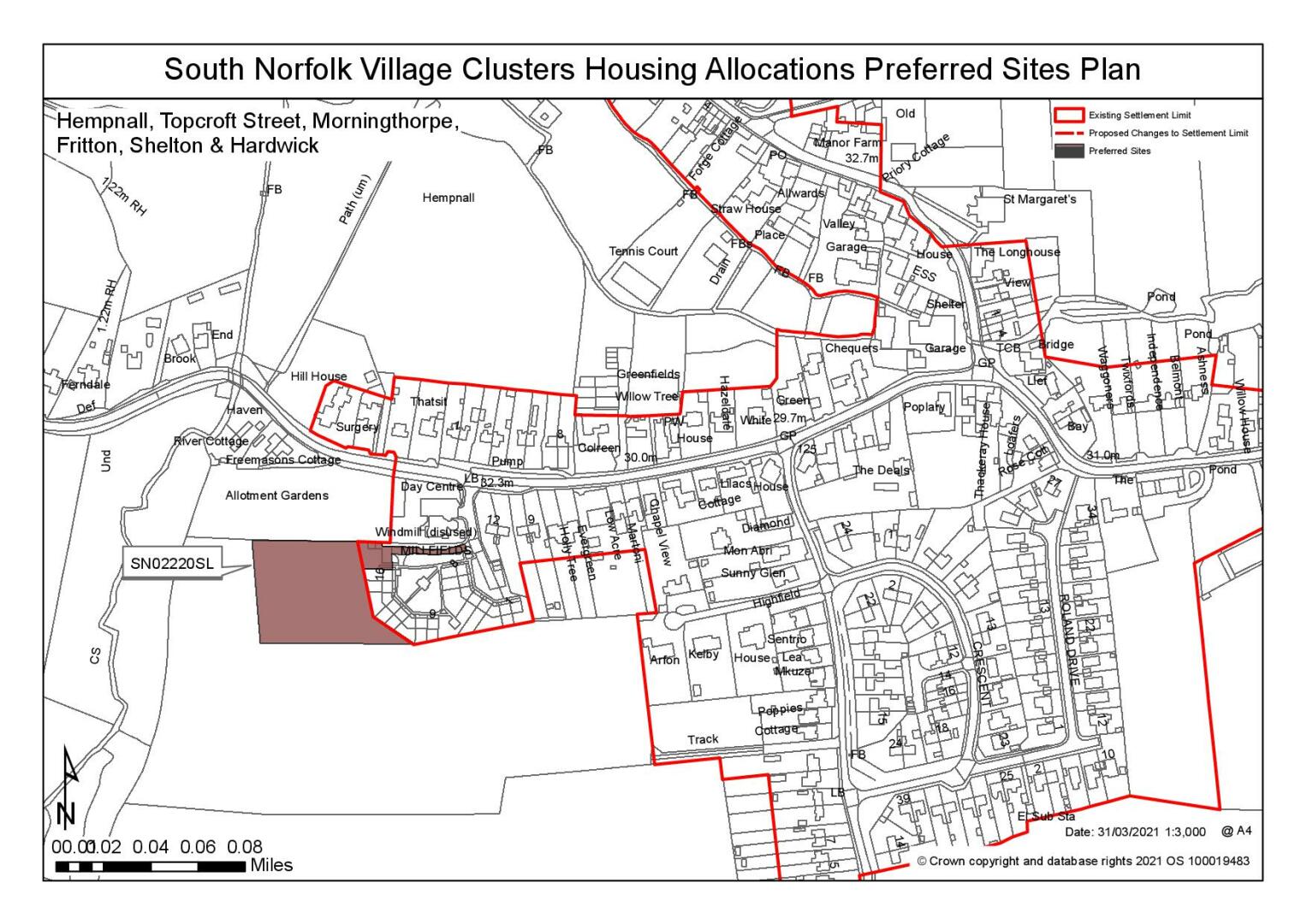
Site: SN0220SL, Land at Millfields |
|
Preferred for up to 15 dwellings on a site of 0.48 hectares Reasoned justification: Whilst the site was originally considered as a settlement limit extension, it has been considered suitable to accommodate allocation scale development. Development will be subject to Millfields (private road) being widened and other off-site highway upgrades. Visibility at the junction with the B1527 appears acceptable, but highway improvements are required for the delivery of development. A safe crossing to facilitate journeys to the school is also required between the site and Field Lane to the east. Heritage constraints have also been identified and in protecting the setting of The Mill, however these could be mitigated through careful design; development should be limited in height to 1 ½ storey. |
|
|
(8) QUESTION 66: Do you support or object to the allocation of the preferred site? Please add additional comments to explain your response and please specify which site(s) you are referring to. If the site is allocated do you think there are any specific requirements that should be set out in the allocation policy?
|
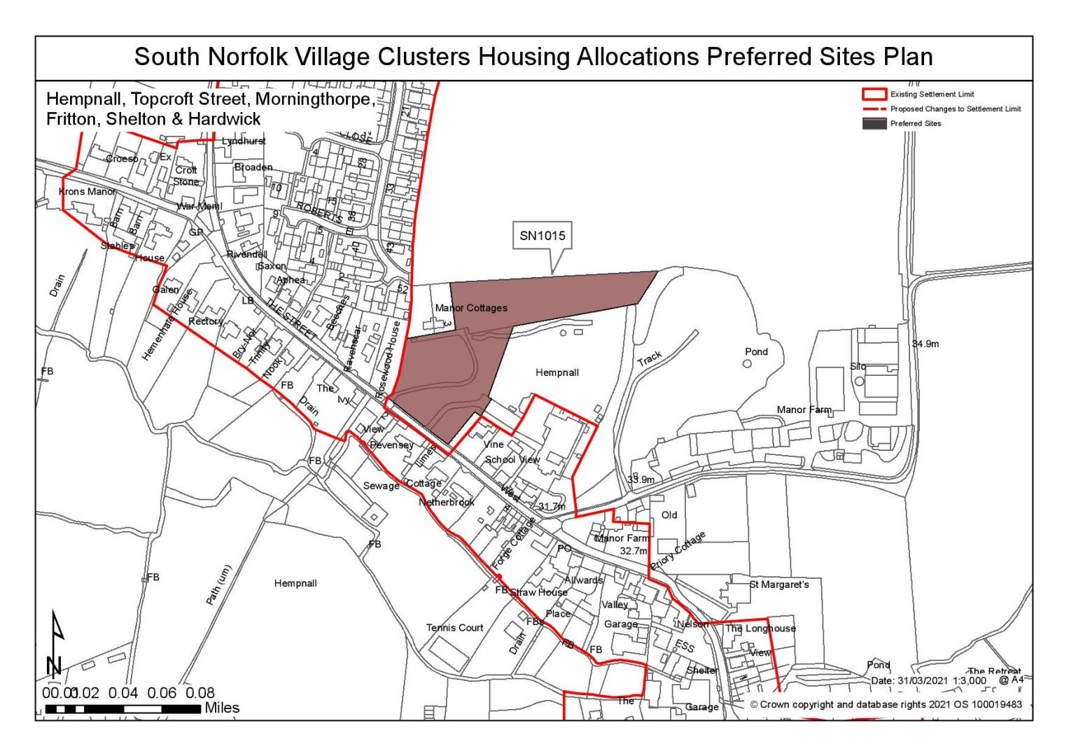
Site: SN1015, Land adjacent to the primary school, The Street |
|
Preferred for 20 dwellings on a site of 1.6 hectares Reasoned Justification: The site benefits from good connectivity and relates well to the existing built form of the settlement. The site is relatively open to the north with a PRoW to the north east site boundary, where development should be lower density to maintain some through views and to reduce the impact on the character of the Conservation Area and setting of the Listed Buildings. Off-site highway works have been identified however these are considered to be achievable. Development would also need to address change in levels across the site. |
|
|
(7) QUESTION 67: Do you support or object to the allocation of the preferred site? Please add additional comments to explain your response and please specify which site(s) you are referring to. If the site is allocated do you think there are any specific requirements that should be set out in the allocation policy?
Rejected Sites
The following site(s) were promoted for development but have been rejected on the basis of information available at the time of assessment.
|
Site |
Location and Reasons for Rejection |
|
SN0147 |
Land around Alburgh Road and Silver Green, Sycamore Farm, 17 Alburgh Road, Hempnall Green The site is considered to be remote from services and facilities where highway safety concerns have also been identified. Access is via field access from Silver Green where it is considered not feasible to construct a satisfactory access and there is no safe walking route to the catchment school. Heritage and landscape constraints have also been identified. |
|
SN0178SL |
Land adjacent Tween Oaks, Alburgh Road The site is remote from services where there is also no safe walking route to the catchment school. Whilst some residential development is located on the western side of Alburgh Road and development at scale promoted could be mitigated by design and landscaping, it has been noted that development would result in loss of significant hedgerow which would be detrimental of character of the lane. The site is open to larger parcels of farmland to the west where there the site would be prominent in this direction. |
|
SN0580 |
Land at Home Farm, Alburgh Road, Hempnall Green The site would have unresolvable highway issues and impact on landscape and townscape. The site is considered to be remote from services where access to the site would require the removal of frontage hedge/trees and provision of a 2.0m wide footway as there is no safe walking route to the catchment school. |
|
SN1016 |
Land at Busseys Loke The site would have a poor relationship with the existing form and character of the settlement. Whilst the site is reasonably close to local services and public transport, it is lacking footpath provision. Significant access and highway network constraints have been identified and are considered to be barriers to the delivery of this site. The site is also heavily constrained by 2 PRoW's (PF7 and PF8) which would require diverting as they cross the middle of the site. |
|
SN1017 |
Land at Broaden Lane The site relates poorly to the existing services, including the primary school, and would have a poor relationship with the existing form and character of the settlement. Development of this site would be harmful in landscape character terms; the site is open in views from the north and west with prominent in views from the highway. |
|
SN1018 |
Land south of Millfields The site is considered to have significant highway safety issues and constraints resulting from the narrow width of the access off Field Lane with no footway. It has also been considered that visibility is not achievable within highway and site frontage. Even with a reduction in site size, the highway issues are considered to be unresolvable. |
|
SN2029SL |
West of Topcroft Street, Toftcroft The site relates poorly to the existing services, including the local school which is over a 3km walk where there is no continuous footpath. It has also been noted that the development would impact on the heritage asset immediately north, where there are also concerns that development here would result in encroachment .The site has also been identified to fall within Flood Zone 2 and 3 which could heavily constrain developable land. |
|
SN2046 |
Land at Pear Tree Farm, Hempnall The site is considered to have poor connectivity and relationship to services, including the primary school. There is also no safe walking route to the catchment school. The site is heavily constrained by significant tree cover within the southern half of the site and by a pond located within the western section of the site (where is also identified surface water risk). This would reduce the area of developable land. |
|
SN2081 |
West of Feld Lane The site has unresolvable highway issues. The site is accessed via Field Lane to the west which has banks/hedging and no footway. It is considered that most/all frontage trees/hedge would need to be removed in order to create a satisfactory access where it has been advised that hedgerow along Field Lane should be retained Landscape constraints have identified that development of site would have a significant impact on form and character of settlement. |
|
SN2146SL |
West of The Street The site has unresolvable highway constraints. Development of the site would also conflict with the linear pattern of development with potential harm to the character of the settlement. The site relates poorly to the existing services, including the local school which is a 3km walk and has no continuous footpath link. Heritage and surface water flood issues have been identified; however, these could be mitigated. |
|
SN4012 |
Land west of Low Road The site is considered is to be remote from the services and facilities within the village cluster, exacerbated by the lack of footways. The site is also considered to be out of keeping in terms of form and character, whilst the site is adjacent to residential dwellings, the site is detached from the main part of Topcroft to the south. |
|
SN4083 |
Land at Bungay Road, Hempnall Frontage development would limit landscape and heritage impacts, however identified flood risk constraints are likely to restrict development on the western part of the site which is closest to the existing settlement. This could result in a poor relationship between new development and existing development along Bungay Road. Whilst the site is reasonably close to local services there is no footpath provision for the first 50m of the site and there appears to be no land available for improvements. |
(5) QUESTION 68: Do you think that any of the shortlisted or rejected sites should be allocated instead of, or in addition to, the preferred site? Please add additional comments to explain your response and please specify which site(s) you are referring to.
To find out more about the Village Clusters Housing Allocations Plan, please visit our Virtual Exhibition.