
South Norfolk Village Clusters Housing Allocations Plan (Reg. 18 Draft)
16. Gillingham, Geldeston, and Stockton
Form and Character
Gillingham
The historic core of the village lies along The Street and Loddon Road, with a further cluster of development at west Kings Dam. Estate development has occurred north of The Street, and the majority of the village (contained within the Settlement Limit) is now in a nucleated form. The older part of the village is characterised by substantial tree planting along Loddon Road, in particular the wooded area to the east and the line of trees along Forge Grove which are protected by a Tree Preservation Order.
The village is set in the Waveney Valley and adjacent to the Broads, and open views out from the village make an important contribution to its rural character. The attractive area around Gillingham Hall and its park was designated as a Conservation Area in 1994. The parish is well served by the A146 (providing direct links to Beccles, Lowestoft, Loddon and Norwich) and the A143 (access to Bungay, Gt Yarmouth, and to the A140 and Diss). The former B1140 provides access to Thurlton and Norton Subcourse.
Geldeston
The main concentration of development is around Geldeston Hill and The Street, with a small detached cluster at West End and isolated Dockeney and Dunburgh Hill. The village has developed in a linear form along The Street with a small post-war council housing estate, The Kells, having been developed by Tayler & Green to the west of Geldeston Hill. Some infill development has occurred along The Street. The A143 to the north of the parish provides a direct road link to Bungay, the A140 and Diss to the west and Beccles and Great Yarmouth to the east and to Lowestoft and Norwich via the A146. Much of the parish to the south of the village lies within the Broads Authority area.
Stockton
Stockton is a sparsely populated parish consisting mainly of individual dwellings and farms set in open countryside. There is a small cluster located around the Church. The A146 runs through the parish and provides direct access to Norwich and Beccles. The A143 in the south provides access to Bungay.
Services and Community Facilities
The cluster has a range of social and community facilities comprising a primary school, village hall and a pub. There is also a shop, recreational facilities and a regular bus service. There is a petrol station and fast-food restaurant to the north at the A146/A143 roundabout.
Settlement Limit and Constraints
Gillingham
The Settlement Limit is in two parts. The first includes the main built form of the settlement. The second part is around the school and adjoining housing, which also extends to include the allocation made within the 2016 Site Allocations Plan for new housing in between the two built-up areas.
The extent of the new housing allocation is limited to land that is within Flood Risk Zone 1. It is not appropriate to allocate a larger site due to the surrounding land being at a higher risk of flooding. Within the land allocated, an allocation of approximately 10 dwellings is considered appropriate to reflect the form and character of existing built development to the west of the site.
It is noted that the existing primary school in Gillingham is operating at capacity. There is an open field adjacent to the school however within which the preferred site is located. Further exploration will be needed to ensure primary school needs can be met.
Geldeston
The Settlement Limit has been drawn to include the two main built-up forms of the settlement along The Street and The Kells, including the small allocation west of Kells Way made within the 2016 Site Allocations Plan. The boundary also includes a small cluster of dwellings east of Geldeston, off The Street.
No alterations are proposed to the existing settlement limits within this cluster.
(15) QUESTION 56: Do you agree with the extent of the Settlement Limit and any changes proposed? If not, please explain what further changes should be made.
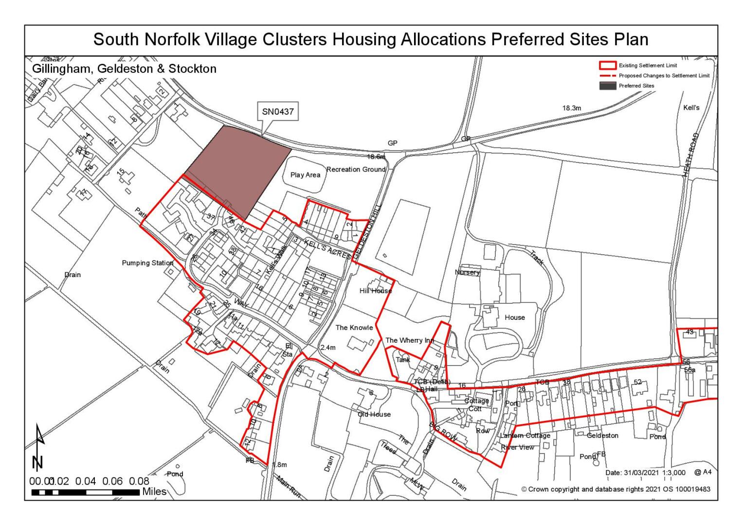
Preferred and Shortlisted Sites
7 sites have been promoted for consideration, of which 2 have been identified as preferred allocations and 2 have been shortlisted.
Preferred Sites
On the basis of the assessment undertaken the following site(s) have been identified as a preferred allocation:
|
Site: SN0437, Land off Kells Way, Geldeston |
|
Preferred for up to 20 dwellings on a site of 0.83 hectares. Reasoned justification: The site has a good relationship with the existing built form of the settlement and would benefit from good connectivity. The site is located to the north of an existing residential development, recently approved and developed. Development of the site would be subject to an access through this recent development as no other access is suitable (Old Yarmouth Road to the north is not viable). Whilst the site adjoins the Conservation Area, any impacts could be mitigated against through careful design and layout. It has been acknowledged that this site has a better relationship with the Valley setting due to existing boundaries. |
|
|
(19) QUESTION 57: Do you support or object to the allocation of the preferred site? Please add additional comments to explain your response and please specify which site(s) you are referring to. If the site is allocated do you think there are any specific requirements that should be set out in the allocation policy?
|
Site: SN0478, Land south of GIL 1, Gillingham |
|
Preferred for 35 dwellings on a site of 1.4 hectares Reasoned Justification: The site would be accessed through the exiting Hopkins Homes development that is currently under construction and which appears to offer a suitable access. Further highway improvements may be required or proposed numbers restricted if highways constraints cannot be resolved. Much of the surrounding area falls within flood zone 2/3, including land immediately to the south of the site. However, the promoter advised that the report produced by Evans Coastal and Rivers in connection with the current development identified the land to be in Zone 1 in relation to Flood. Further investigation (FRA) would be required to confirm this prior to allocation. It is also noted that the boundaries of the site can be adjusted if required as surrounding fields are in the same ownership. Landscape constraints have been identified as site is in close proximity to the Broads (King's Dam) and footpaths run parallel to the south and west of the site. A landscape assessment would need to be undertaken to demonstrate that there would not be unacceptable landscape impacts. |
|
|
.jpg)
(27) QUESTION 58: Do you support or object to the allocation of the preferred site? Please add additional comments to explain your response and please specify which site(s) you are referring to. If the site is allocated do you think there are any specific requirements that should be set out in the allocation policy?
Shortlisted Sites
On the basis of the assessment undertaken the following site(s) have been shortlisted:
|
Site |
Reasons not preferred for allocation: |
|
SN0274 REVA or REVB |
Land to the south of the A143 and A146 roundabout, Gillingham Shortlisted for up to 25 dwellings on a site of 2 hectares.
SN0274 REV A and REV B are immediately adjacent to one another and have therefore been assessed together. Both sites are subject to flood risk constraints. However, the development to the south (application reference: 2019/1013) also falls within Flood Zone 2/3a but the applicant submitted a Flood Risk Assessment (FRA) which identifies the actual 'Residual Risk and Flood Zones' on site and all of the 22 homes proposed were able to be sited within Flood Zone 1. Any allocation of this site would be subject to further investigation to determine the extent of flooding and whether development on one or both of these sites could also be accommodated within Flood Zone 1. The site has few other constraints. The Highways Authority have recognised that the site could provide further highways enhancements with the widening of The Street. In addition, an application to extend the service station to the north of the site has recently been approved where a linkage to the rest of the village has been suggested. It is considered that development of the site could provide this linkage and development in this location could be coherently planned to maximise any opportunities for connections to be created. Due to the sites being adjacent and of the same ownership, it has been identified that the site boundary could extend across REVA and REVB to help mitigate flood risk issues is necessary. |
Rejected Sites
The following site(s) were promoted for development but have been rejected on the basis of information available at the time of assessment.
|
Site
|
Location and Reasons for Rejection |
|
SN0091 |
Land to the north and east of Church Farm, Church Road, Stockton The site is considered to be remote from services and cannot provide a reasonable or safe walking route to the primary school. The site is detached from the main areas of the settlement and is not adjacent to any existing settlement boundaries. Highway safety constraints have been identified; development of the site could lead to an intensification of slowing, stopping and turning movements onto A146 Principal Route The local road network is limited in width, lacks passing provision and has no footways. It has also been noted that visibility may be require third party consent. |
|
SN0207 |
Land off Old Yarmouth Rd/ Geldeston Hill, Geldeston |
|
SN0276 and SN021SL |
Land to the east of the Village Hall, Gillingham The site is considered unsuitable for allocation or an SL extension, due to highway safety constraints. Access to the site would need to come through the village hall car park which is 3rd party land that has not been presented as an option. In addition to this, if access could be achieved there would be issues with junction visibility to the north and south on Loddon Road (which is a busy route from the A146 into Beccles). It is considered that this would be difficult to resolve with the junction to The Street opposite. The site is also heavily constrained by tree cover and also suffers from some small areas at risk of fluvial or surface water flooding to the eastern boundary. It is also noted that the majority of the site falls within the Broads Authority executive area. |
|
SN1004 |
Land off Old Yarmouth Rd/ Geldeston Hill, Geldeston It is considered that safe access is not achievable due to visibility constraint caused by adjacent building. Whilst the site is located adjacent to the existing SL limited, the site is backland development, out of keeping with the exiting settlement pattern, with potential amenity concerns for existing residents. It has also been identified that the site is located within the Geldeston Conservation Area and there are a number of listed buildings within close proximity of the site. |
(8) QUESTION 59: Do you think that any of the shortlisted or rejected sites should be allocated instead of, or in addition to, the preferred site(s)? Please add additional comments to explain your response and please specify which site(s) you are referring to.
(6) QUESTION 60: Do you think that any of the shortlisted sites should be rejected? Please add additional comments to explain your response and please specify which site(s) you are referring to.
To find out more about the Village Clusters Housing Allocations Plan, please visit our Virtual Exhibition.