
South Norfolk Village Clusters Housing Allocations Plan (Reg. 18 Draft)
17. Hales and Heckingham, Langley with Hardley, Carleton St Peter, Claxton, Raveningham and Sisland
Form and Character
Hales
Development in Hales has been concentrated around Yarmouth Road east of the A146 Beccles Road. Individual dwellings and farmsteads are sparsely distributed through the remainder of the parish.
The village has developed along the historical road network of Yarmouth Road, School Lane and Briar Lane. There has been significant modern infill development together with some limited estate development which has resulted in a more nucleated settlement form.
The village is set in an attractive valley landscape which contributes to its rural setting. Hales is adjacent to the A146 which provides a good link to Norwich, Beccles and Loddon whilst the B1136 provides relatively good access to Haddiscoe, and then to Great Yarmouth via the A143.
Heckingham
Part of the built up area of Hales lies within the parish of Heckingham, however the remainder of the settlement is sparsely populated comprising a small number of dwellings and farmsteads set in open countryside. The A146 to the south of the settlement provides a good link to Norwich.
Carleton St Peter
Carleton St Peter is a sparsely populated parish consisting of a small number of individual dwellings and farms set in a predominately valley landscape.
Langley with Hardley
Development within the parish has been concentrated into tree small groups at Langley Green, Langley Street and Hardley Street with individual dwellings and farmsteads widely dispersed throughout the remainder of the parish. The three groups of development are set on the edge of Langley and Hardley Marshes within the Yare Valley. In the west of the parish is the historic parkland of Langley Park. The character of the developed areas is of a dispersed nature comprising small scattered ribbons of development together with the attractive valley setting combine to give the area an attractive rural character adjacent to the Broads.
Claxton
Development within the parish has been concentrated along The Street with a few isolated dwellings and farmsteads scattered throughout the remainder of the parish. The village, located on the edge of the Broads Area, is set in the attractive Yare Valley with extensive marshlands to the north and a gently sloping valley to the south.
The village has a strong linear settlement form with dwellings generally set back from the road although the older cottages at the east end of The Street are built-up close to the road in a traditional style.
Raveningham
Raveningham displays a dispersed rural settlement pattern consisting of individual dwellings and farms set in open countryside with significant areas of woodland, in particular the historic parkland of Raveningham Park. The parish has good access to Haddiscoe and the A143 to the east and Hales, Loddon and A146 to the west.
Sisland
The parish is sparsely populated consisting of a few individual dwellings and farms set in an attractive valley landscape. Mundham Road which runs immediately south of the parish provides direct access to Loddon and the A146.
Services and Community Facilities
The cluster has a range of social and community facilities including a village hall and shop at the Hales Service Station on the edge of the village. There is outdoor recreation space and public transport links. There is also a public house and some employment opportunities.
Settlement Limit and Constraints
Hales
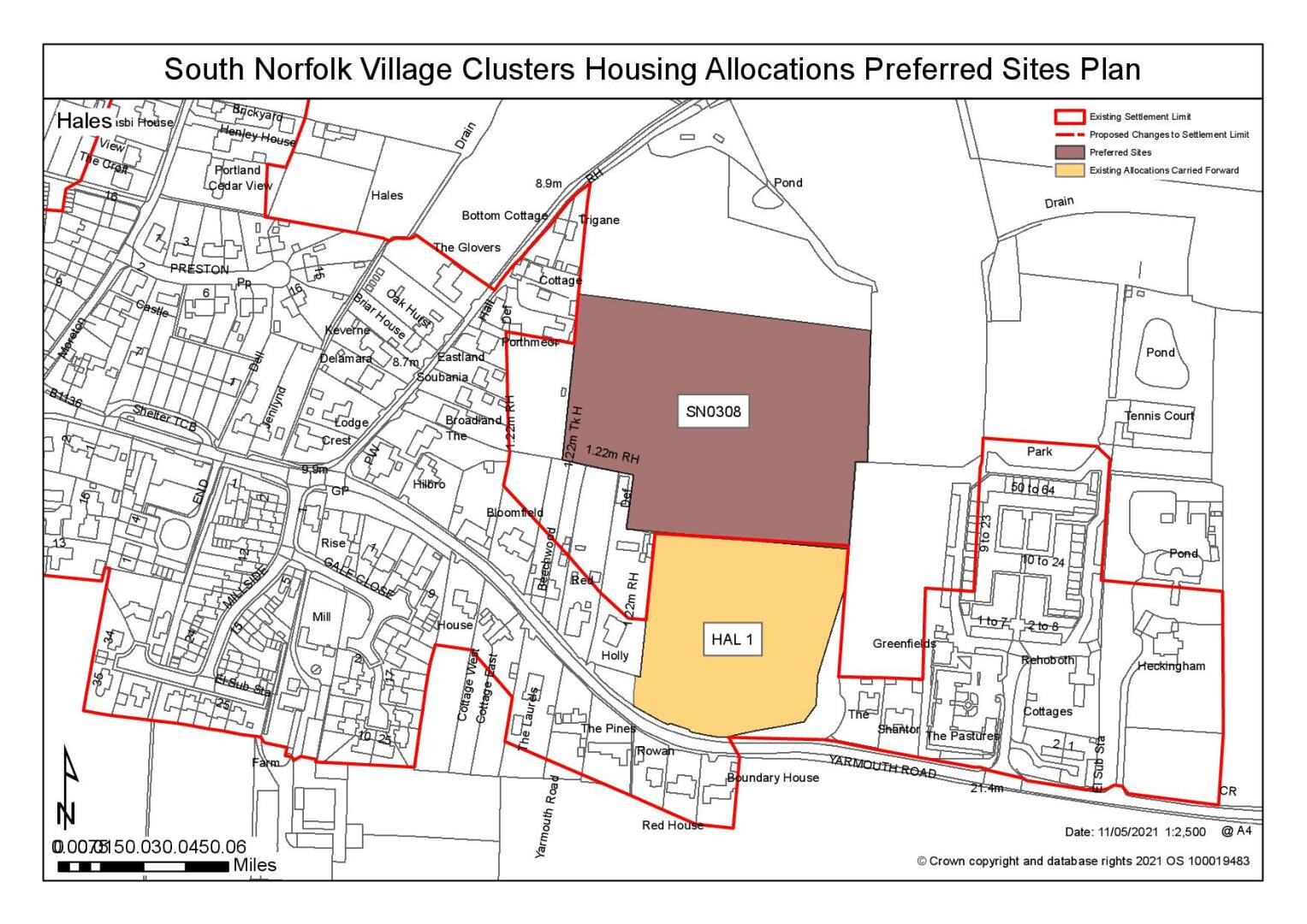
The Settlement Limit has been drawn to include the main built form of the settlement, development around the former Hales Hospital and land allocated (HAL 1) within the 2016 Allocations Plan for residential development in between.
Claxton
The Settlement Limit has been drawn to include the main built form of the settlement that is within South Norfolk and allows for some limited infill development. Much of the surrounding area falls within the Broads Executive area.
No alterations are proposed to the existing settlement limits within this cluster.
(4) QUESTION 61: Do you agree with the extent of the Settlement Limit and any changes proposed? If not, please explain what further changes should be made.
Preferred and Shortlisted Sites
2 sites have been promoted for consideration, of which 1 has been identified as a preferred allocation.
Preferred Sites
On the basis of the assessment undertaken the following site(s) have been identified as a preferred allocation:
|
Site: Part of SN0308, Land off Briar Lane, Hales |
|
Preferred for up 35 dwellings on a site of 1.4 hectares. Reasoned justification: The site is well located to access the available local facilities. Hales also benefits from a continuous footway to employment and higher order services in Loddon, as well as being on the main Lowestoft/Beccles/Norwich bus route. The site as promoted it too large, but a more restricted site (approx. 1/3 of the land promoted) would be less intrusive in the landscape and on the setting of the listed former Hales Hospital, as well as allowing for any necessary mitigation of the 1:1000 year surface water flood risk. The site would need to be accessed via the current HAL1 allocation, which has outline consent for 20 dwellings. |
|
|
(13) QUESTION 62: Do you support or object to the allocation of the preferred site? Please add additional comments to explain your response and please specify which site(s) you are referring to. If the site is allocated do you think there are any specific requirements that should be set out in the allocation policy?
Rejected Sites
The following site(s) were promoted for development but have been rejected on the basis of information available at the time of assessment.
|
Site |
Location and Reasons for Rejection |
|
SN0530 |
Land west of Claxton Church Road, Claxton The site is poorly located for access to services either within this Village Cluster, or within the adjoining cluster of Thurton and Ashby St Mary (some of which are closer) and Highways do not consider a suitable access can be achieved to the site from Church Lane. The site is very rural with consequent detrimental impacts on the relatively open landscape (visible from highways and footpaths) and development would effectively be an isolated group of dwellings in the countryside. There are also heritage assets in the vicinity, including the Grade 1 Listed St Andrew's Church, and protected species (brown hare) have been noted on site. |
(1) QUESTION 63: Do you think that the rejected site should be allocated instead of, or in addition to, the preferred site? Please add additional comments to explain your response and please specify which site(s) you are referring to.
To find out more about the Village Clusters Housing Allocations Plan, please visit our Virtual Exhibition.