
South Norfolk Village Clusters Housing Allocations Plan (Reg. 18 Draft)
7. Bressingham
Form and character
The parish contains a number of scattered settlements of which the largest are the part of Bressingham located on High Road and Bressingham Common located along Common Road. Both settlements are mainly linear in form and are separated and surrounded by large open fields. Both settlements are distinguished by many trees and hedgerows contributing greatly to their rural character and are afforded views across the Waveney Valley by the downward sloping land to the south.
Services and Community Facilities
The village has a small range of services including a Village hall, shop, limited bus service and a primary school. Bressingham garden centre provides for some employment opportunities locally.
Settlement Limit and Constraints
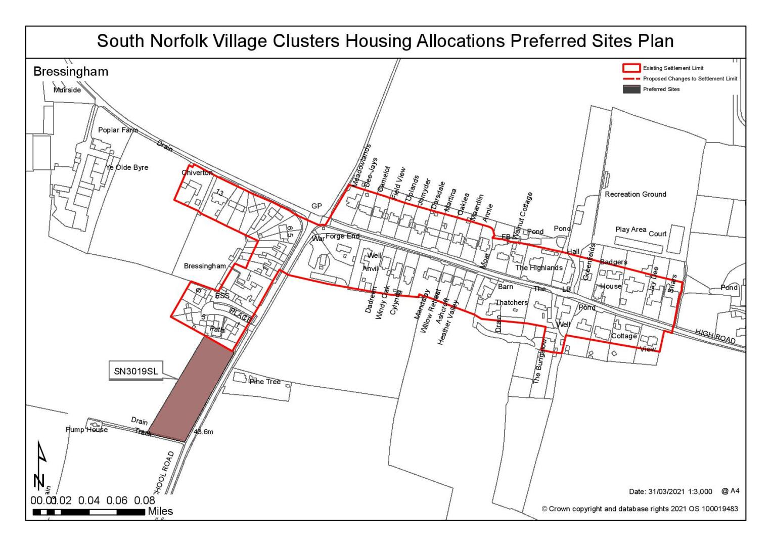
The Settlement Limit has been drawn to include the two main built forms within Bressingham off Common Road and the Street, and to provide some limited infill within it without affecting the setting of 'The Grange' on High Road or the form and character of the Settlement. The remainder of Bressingham is very dispersed and therefore unsuitable for the creation of a Settlement Limit without leading to significant development which would fundamentally alter the character of the area. No alterations are proposed to the existing Settlement Limit.
(13) QUESTION 29: Do you agree with the extent of the Settlement Limit and any changes proposed? If not, please explain what further changes should be made.
Preferred and Shortlisted Sites
17 sites have been promoted for consideration, of which 2 have been identified as preferred allocation and 1 further site shortlisted.
Preferred Sites
On the basis of the assessment undertaken the following site(s) have been identified as a preferred allocation:
|
Site: SN3019, Land west of School Road |
|
Preferred for up to 12 dwellings on a site of 0.49 hectares. Reasoned justification: The site was initiallypromoted as a Settlement Limit extension, however as it is of a scale that is only just below the nominal 0.5ha allocation threshold it has been identified suitable as an allocation. The site is well related and connected to the centre of the settlement where there is an existing footpath provision. Areas within the eastern section of the site are identified as being at risk of surface water flooding, however this forms the site frontage and is not expected to prevent development. |
|
|
(29) QUESTION 30: Do you support or object to the allocation of the preferred site? Please add additional comments to explain your response and please specify which site(s) you are referring to. If the site is allocated do you think there are any specific requirements that should be set out in the allocation policy?
|
Site: SN4036 - Land to the east of School Road |
|
Preferred for up to 40 dwellings on a site of 2.09 hectares. Reasoned justification: The site is well related and connected to existing services and facilities; it relates well to the settlement and has limited on-site/ off-site constraints identified. A larger site area that needed for the residential development is identified as it is proposed that the site includes proposed parking for the adjacent school and also to allow for the provision of a large area of open space to protect the setting of the adjoining listed building. |
|
|

(29) QUESTON 32: Do you support or object to the allocation of the preferred site? If the site is allocated do you think there are any specific requirements that should be set out in the allocation policy?
Shortlisted Sites
On the basis of the assessment undertaken the following site(s) have been shortlisted:
|
Site
|
Location and reasons not preferred for allocation: |
|
SN4037 |
Land to the south of Fersfield Road, Bressingham. Shortlisted for up to 25 dwellings on a site of 1.29 hectare. The site relates well to the existing settlement and would not have a detrimental impact on the landscape or townscape. It is anticipated that other constraints identified could be subject to suitable mitigation measures. |
Rejected Sites
The following site(s) were promoted for development but have been rejected on the basis of information available at the time of assessment.
|
Site |
Location and Reasons for Rejection |
|
SN2052 |
East of The Street, Bressingham. The site has limited access to services and facilities. Site has significant surface water flood risk issues with flow path running across site. Potential harm to open setting of nearby listed buildings. Concerns over highway impacts. |
|
SN2053 |
Adjoining Pond Farm, Bressingham. The site has limited access to services and facilities. Site has significant surface water flood risk issues with flow path running across site. Potential harm to open setting of nearby listed buildings. Concerns over highway impacts |
|
SN2054 |
Land east of School Road, Bressingham. Has a good relationship to services and facilities, but due to its scale and relationship to the existing settlement, the development of the site would have a significant detrimental effect in terms of landscape and the form and character of the area (townscape). |
|
SN2056 |
Land at Fersfield Common, Bressingham. The site has limited access to services and facilities. Site is subject to surface water flood risk issues. Development of the site would have an adverse effect on local landscape due to limited built form in the immediate area. Concerns over suitability of local highway network. |
|
SN2057 |
North of A1066, Bressingham The site is relatively well connected to existing services. However, development will be constrained by the need to protect the setting of nearby listed buildings, potential highways issues and the landscape concerns due to its position in a designated River Valley. Site is unlikely to achieve a level of development that would make it suitable for allocation. |
|
SN2079 |
Land at Fersfield Road/ Folly Lane, Bressingham Whilst the site is well related to existing services and facilities, it lies within a prominent position in the landscape, with the potential to result in adverse impacts on the local setting. |
|
SN3010 |
Wyevale Garden Centre, Bressingham The site is poorly related to core services within the settlement and this is reinforced by the separation resulting from the main road. The site would result in a loss of employment. Development of the whole site would be outside the scale proposed by the VCHAP but smaller scale development would result in piecemeal development in an unsustainable location. |
|
SN3020 |
Land west of School Road, Bressingham. The site is separated from and therefore has poor relationship with the existing settlement. Consequently, development of this site is considered to have an unacceptable impact on the local landscape setting and character and appearance of the area. This impact would be particularly significant if the adjacent site is not considered suitable for development. |
|
SN3023SL |
South of Darrow Lane, Bressingham. The site is isolated from, and poorly related/connected to the existing settlement. There are further Identified constraints including highway and amenity issues and landscape (tree) constraints. |
|
SN3036 |
South of Low Road, Bressingham. The site is detached from the main settlement and separated from it by the A1066. This results in a poor relationship with resultant detrimental impacts on the landscape and character and appearance of the area and diminished access to services and facilities. The site is potentially constrained by highways issues. |
|
SN3037 |
North of Low Road, Bressingham. The site is not well connected to the main settlement, nor does the site relate well physically to the main settlement. This results in detrimental impacts on the landscape and character and appearance of the area and diminished access to services. The site is likely to be constrained by highways issues. |
|
SN3038 |
South of High Road, Bressingham. The site is detached from the main settlement and separated from it by the A1066. This results in a poor relationship with resultant detrimental impacts on the landscape and character and appearance of the area and diminished access to services and facilities. The site is potentially constrained by highways issues |
|
SN4026 |
Land east of Common Road, Bressingham. The site is detached and poorly connected to the main settlement. This diminishes access to services and facilities. The site is prominent within the landscape and its development would result in a hard edge in what is an otherwise rural setting. This results in detrimental impacts on the landscape. Highway concerns have been identified. |
|
SN4033 |
Rear of 34 Common Road, Brressingham. Whilst the site is reasonably well located to services in distance terms there is no continuous footpath, which diminishes accessibility. The site is constrained by issues relating to highways, residential amenity and landscaping (trees). |
(11) QUESTION 31: Do you think that any of the shortlisted or rejected alternative site(s) should be allocated instead of, or in addition to, the preferred site? Please add additional comments to explain your response and please specify which site(s) you are referring to.
(6) QUESTION 32: Do you think that any of the shortlisted sites should be rejected? Please add additional comments to explain your response and please specify which site(s) you are referring to.
To find out more about the Village Clusters Housing Allocations Plan, please visit our Virtual Exhibition.