
South Norfolk Village Clusters Housing Allocations Plan (Reg. 18 Draft)
26. Needham, Brockdish, Starston and Wortwell
Form and Character
Needham
Needham is a linear village of mainly detached dwellings on single plot frontage along the former A143. The village is located along the foot of the northern valley slope of the River Waveney. Most development has been concentrated between the village hall and Whitehouse Farm in a linear form.
The northern end of the village has a more open aspect and includes a semi-derelict sunken area of ex-gravel pits. The surrounding area comprises valley slopes rising above the village to the north and characterised by large fields with few hedgerows or trees. To the south, the valley floor has a mixture of arable fields and many mature trees providing an attractive rural setting.
Brockdish
The parish contains Brockdish and Thorpe Abbotts. Brockdish is primarily a linear village located along the northern side of the Waveney Valley close to the A143. The village core is centred on the junction of The Street/Scole Road and Grove Road.
A separate area of residential development is located a short distance to the west near the church. Separation of these two distinct parts of the settlement should be maintained in order to preserve the character of the conservation area with its many listed buildings.
Thorpe Abbotts comprises a small group of mainly detached houses located on frontage plots around the junction of The Street and Mill Road, approx. 2.5 kilometres west of Brockdish. There has been a conservation area designated around Thorpe Abbotts since 1994.
Starston
The parish contains a dispersed form of development which includes a ribbon of development fronting onto The Street. The row extends along the northern slopes of a shallow valley toward the junction with Church Hill, Redenhall Road, Railway Hill and Harleston Road which, combined with the setting of the church and the bridge, forms an attractive focal point. A wide area is defined as a conservation area which is distinguished by the presence of some notable buildings. The surrounding area is open and affords distant views.
Wortwell
There are two main areas which together form the established village of Wortwell. The main part of the village is along the line of High Road whilst the remainder, known as Low Street, has developed along Low Road. Individual dwellings and farmsteads are dispersed throughout the remainder of the parish. The A143, which bypasses the village, provides good links to Harleston, the A140 and Diss to the west, and to Bungay and the A146 to the east.
Services and Community Facilities
The cluster has a range of social and community facilities including village halls and public houses. The villages also have recreation areas, local employment opportunities and bus services.
Settlement Limit and Constraints
Needham
The settlement is constrained to the west by the Bypass and Flood Zones 2 and 3 to the north and east. The Settlement Limit is drawn to provide for some limited infill development within the existing village core. The area of development adjacent to the Harleston bypass roundabout is excluded as it is within the flood zone. The Settlement Limit also excludes the church and village hall and the land opposite as it contributes to the open character and rural appeal of this part of the village. No alterations are proposed to the existing Settlement Limit.
Brockdish
The Settlement Limit has been drawn to include the main built form of the settlement at Brockdish and allow for some limited sensitive infill within it. A minor addition to the Settlement Limit has been drawn to include a single dwelling that was approved adjacent to the eastern edge of development along The Street in January 2019 (2018/2293). This change will be shown on the policies map
No Settlement Limit has been defined at Thorpe Abbotts due to the extensive conservation area and its remoteness from services and facilities.
Starston
Due to its dispersed character, attractive valley landscape and extensive conservation area, the Settlement Limit has been drawn to reflect the existing settlement form in three separate parts to prevent further development extending into the surrounding open countryside. No alterations are proposed to the existing Settlement Limit.
Wortwell
The Settlement Limit has been drawn to include the main built form of the settlement along High Road. A minor extension to the Settlement Limit has been drawn to include the three dwellings granted planning permission in October 2018 (2018/2019) to the south of High Road. This change will be shown on the policies map.
(2) QUESTION 91: Do you agree with the extent of the Settlement Limit and any changes proposed? If not, please explain what further changes should be made.
Preferred and Shortlisted Sites
15 sites have been promoted for consideration, of which 3 were identified as preferred allocations. No further sites were identified as shortlisted sites.
Preferred Sites
On the basis of the assessment undertaken the following site(s) have been identified as a preferred allocation:
|
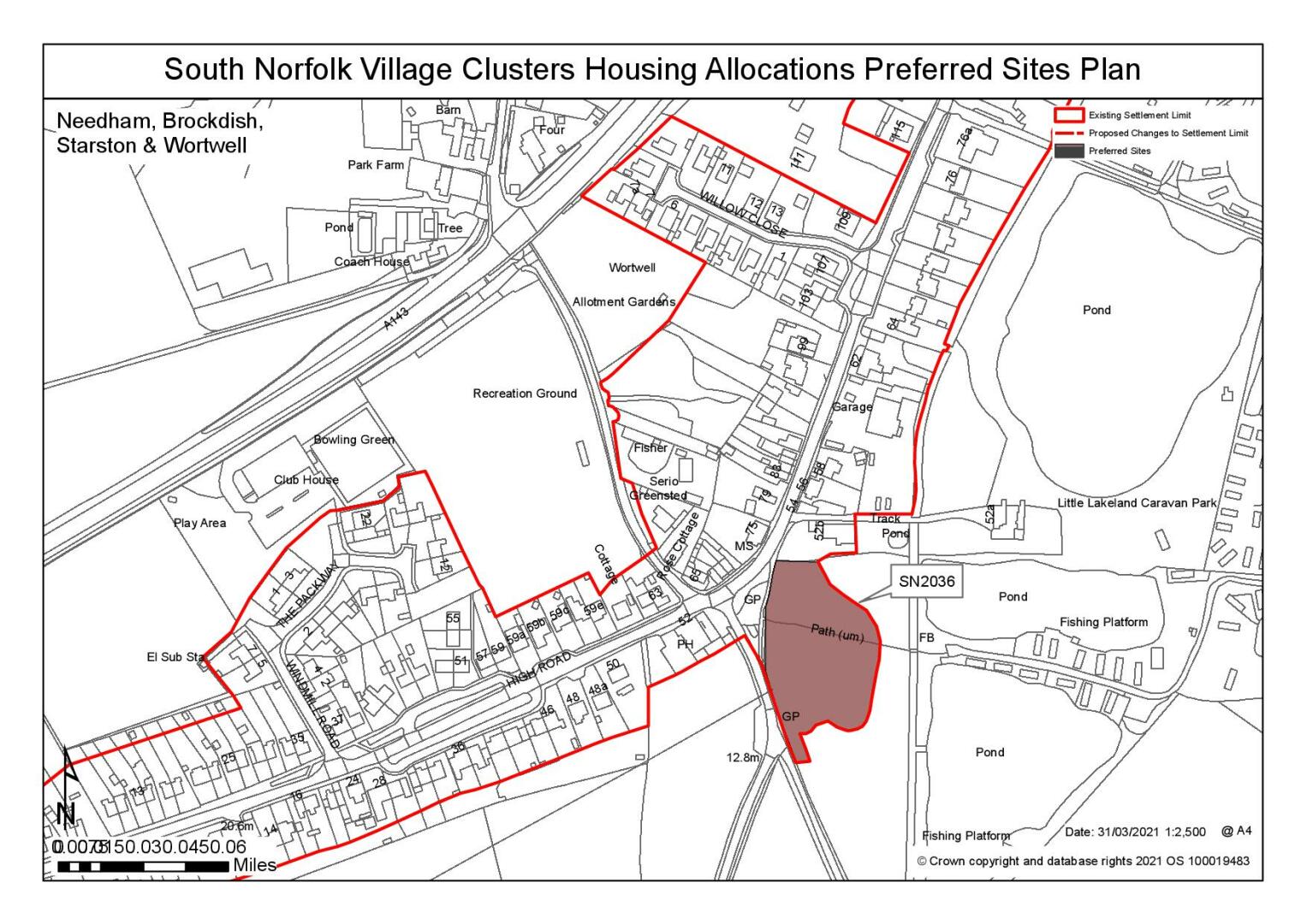
Site: SN2036, Land at the junction of High Road and Low Road, Wortwell |
|
Preferred for 10 dwellings (net gain of 5) on a site of 1.31 hectares Reasoned justification: Part of the site is already allocated for approximately 5 dwellings in the current Local Plan (WOR1). The site promoter is seeking a small increase in numbers, with some affordable units and an area of wildlife/amenity land. This should be achievable within the existing allocated site, which extends to 0.4ha, and Policy WOR1 already requires provision of amenity space on adjoining land, outside the Settlement Limit. However, any amended Policy would need to emphasise the requirements to protect the setting of the listed pub opposite and the rural gap between the parts of Wortwell centred on High Road and Low Road. Any increase in numbers could also have implications in terms of further highways improvements. The remainder of the site which is not currently allocated is Flood Risk Zones 2 and 3, and contributes to the rural gap within the village, and therefore would not be appropriate to allocate for housing. |
|
|
(8) QUESTION 92: Do you support or object to the allocation of the preferred site? Please add additional comments to explain your response and please specify which site(s) you are referring to. If the site is allocated do you think there are any specific requirements that should be set out in the allocation policy?
|
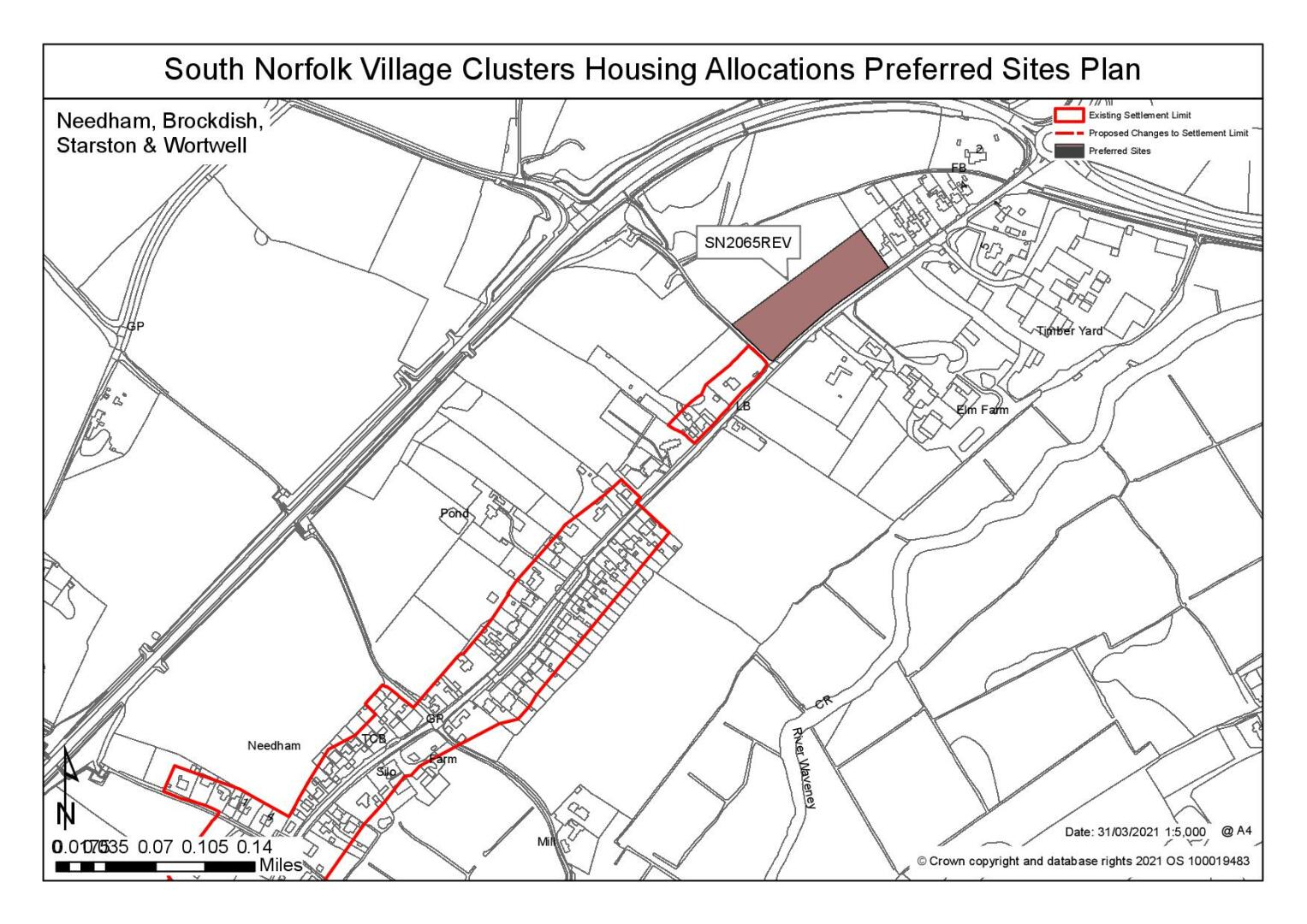
Site: SN2065REV, Land north of High Road and Harmans Lane, Needham |
|
Preferred for up to 15 dwellings on a site of 0.9 hectares Reasoned justification: The site is adjacent to the settlement limit and the services of the village are accessible as there is a continuous footpath along High Road. The site could provide for enhancement to cross the A143, such as a central refuge, to improve connectivity to Harleston and the school. The site is within the river valley but contained within the landscape on the opposite side of the road to the river. The frontage hedge is not continuous, and access could be achieved with minimal loss. The site area has been reduced to remove from Flood Zones 2 and 3 to the rear. |
|
|
(7) QUESTION 93: Do you support or object to the allocation of the preferred site? Please add additional comments to explain your response and please specify which site(s) you are referring to. If the site is allocated do you think there are any specific requirements that should be set out in the allocation policy?
|
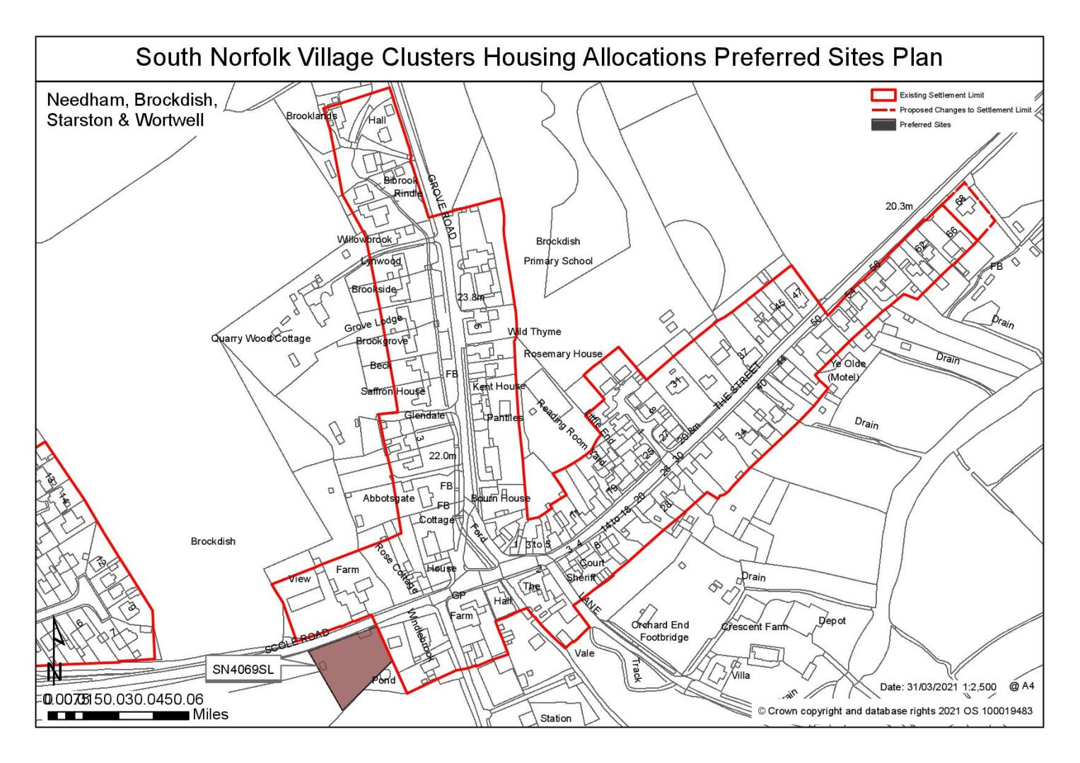
Site: SN4069SL, Land south of Scole Road, Brockdish |
|
Preferred for a Settlement Limit Extension on a site of 0.18 hectares. Reasoned justification: The site is adjacent to the settlement limit, and although it is 6k to the primary school it does have access to other facilities. It is in the main part of the village and would be an extension to the built form respecting the existing pattern of development with only a very localised and limited impact on the river valley and Conservation Area. There is an existing access and any loss of leylandii along the frontage would not be detrimental. |
|
|
(5) QUESTION 94: Do you support or object to the proposed use of the site? Please explain your reasons
Rejected Sites
The following site(s) were promoted for development but have been rejected on the basis of information available at the time of assessment.
|
Site
|
Location and Reasons for Rejection |
|
SN0057 |
Land south of Sancroft Way, Wortwell The site is contained however it is also in an elevated position and would intrude into the River Valley landscape. Concerns have also been raised about the connectivity of the site – access via Sancroft Way appears to be subject to a ransom strip and access via Low Road is not achievable in highway safety terms |
|
SN0156 & SN0156REV |
Site opposite village hall, High Road, Needham The site is adjacent to the settlement limit and the services of the village are accessible as there is a continuous footpath along High Road. However, the site is within the river valley with open, uninterrupted views from and of the Listed church. It would have a significant detrimental impact on the setting of the church and within the landscape, from the Angles Way trail and the wider footpath network. |
|
SN0385 |
Land west of Church Lane, Brockdish The site is adjacent to the settlement limit, and although it is 6k to the primary school it does have access to other facilities. However, Church Road is narrow and achieving an adequate access would be problematic. Because access would be from Church Road as there is no opportunity through the existing estate, it would have a poor relationship with the existing settlement. It would also be a significant intrusion into the landscape extending the built-up area northwards and not respecting the existing pattern of development. |
|
SN0464SL |
Land west of Mill Road, Thorpe Abbots Thorpe Abbots is a small hamlet with very few services and facilities and is 8k from the nearest primary school. The roads are narrow and there is no footpath provision resulting in access being predominantly by car and no safe walking route to the school. The site is within a Conservation Area and its open aspect contributes to the rural character of the hamlet and development would have a detrimental impact on the landscape and townscape. Achieving an access and footway would require on site and frontage hedge/tree removal and there is a surface water flood risk. |
|
SN2001SL |
Land west of Cross Road, Starston Starston currently does not have a settlement limit. The site is in a rural location and would represent an encroachment into the open countryside. Significant highways concerns, particularly relating to the wider road network, have been identified. |
|
SN2006SL |
Land north of High Road (between No171 and Meadow Cottage), Wortwell The site is in a rural setting with limited development, and lies wholly within a River Valley setting. Development of the site would result in the loss of a gap that contributes positively to the rural character of the area. |
|
SN2121A |
Land south of High Road, Wortwell Whilst the site is reasonably located for the local facilities in Wortwell, pedestrian access would require a suitable crossing on High Road. However the site has a number of overriding constraints: it has not been demonstrated that suitable visibility splays can be achieved on the inside of the bend in High Road, particularly given the TPO tree on the highway boundary; there are likely to be significant mitigation measures necessary to address surface water flood risk (if this is achievable at all); the site as proposed would be out of keeping in terms of townscape, introducing an uncharacteristic form of estate development; and even reduced to frontage only development, the site would extend the settlement further into the designated River Valley Landscape. |
|
SN2121B |
Land west of Low Road, Wortwell The site is centrally located within the village; however, this location would have implications for the character of the area and the designated River Valley landscape, as it would significantly close the gap between the parts of the village along High Road and Low Road. An application for a single dwelling in this gap was refused at appeal in 2018 due to the impact on the character of the area. The site would also impact on the setting of the adjacent Wortwell Bell public house. A 2018 planning application on the part of the site closest to the pub was also refused due to the loss of important hedgerow and possible conflict between the amenity of future residents and the viability of the pub. |
|
SN2121C |
Land north of Sancroft Way, Wortwell The site would erode the attractive River Valley landscape that separates the areas of Wortwell centred on High Road and Low Road. The site would also adversely impact on the setting of the two listed buildings on the opposite side of Low Road, Says Farmhouse and Tyrells Barn. A single dwelling on this site was dismissed at appeal in 2018 for the aforementioned reasons, despite a lack of land supply at the time. Highways also consider Low Road in this vicinity to be substandard in terms of width and footways. |
|
SN4063 |
Mill Hill, High Road, Wortwell The site would have a poor relationship with the existing linear pattern of development and which would result in an adverse landscape and townscape impact. Significant highways concerns have also been raised about the potential to create a suitable vehicular access to the site. |
|
SN4066SL |
Land adjacent to 29 Low Road, Wortwell The site is at significant risk of flooding although a frontage development scheme may be acceptable subject to significant flood risk assessment. However, the site is wooded and contributes significantly to the landscape character and development of the site would consequentially result in an adverse impact on the River Valley landscape setting. Highways constraints have also been identified. |
|
SN4084 |
Land east of Low Road, Wortwell The site is almost entirely within Flood Risk Zones 2 and 3, and the LLFA has also identified severe constraints, requiring significant mitigation, in terms of surface water flood risk. The site would significantly erode the rural River Valley gap between the parts of the settlement centred on High Road and Low Road and the form/layout of the site would have a poor relationship with existing development on Low Road. There are also potential impacts on the rural setting of the listed Tyrells Barn, when approaching from the north. Highways have identified that Low Road is substandard in the vicinity of the site. |
(8) QUESTION 95: Do you think that any of the shortlisted or rejected sites should be allocated instead of, or in addition to, the preferred site? Please add additional comments to explain your response and please specify which site(s) you are referring to.
To find out more about the Village Clusters Housing Allocations Plan, please visit our Virtual Exhibition.