
South Norfolk Village Clusters Housing Allocations Plan (Reg. 18 Draft)
25. Mulbarton, Bracon Ash, Swardeston and East Carleton
Form and Character
Mulbarton
Historically Mulbarton developed with cottages and individual properties fronting the three roads around The Common. More recently, estate development has taken place on a large scale to the south of The Common which has altered the form and character of the village. As a result of past planning policies, The Common has remained as a large undeveloped space in the centre of the village and is important in terms of both visual amenity and recreation opportunities. There has been little development on the edges of The Common in order to preserve its impressive open appearance and allow views out over the surrounding countryside, drawing the countryside into the 'core' of the village.
There is also a good buffer of open farmland between the B1113 and the western edge of new residential areas south of The Common which contributes to the setting of the village.
The view of the church, north of The Common, is prominent from all parts of The Common. The special character of this area has been recognised by the designation of a Conservation Area in 1977, which was extended in 1994.
Bracon Ash
The parish of Bracon Ash lies to the south-west of Mulbarton on the B1113. There are three distinct settlement groupings, including the area around the church and the area at Hethel. The main settlement has developed in a linear fashion along The Street, Hawkes Lane and Poorhouse Lane and comprises mainly frontage properties. It is separated from Mulbarton by agricultural land to the south of Cuckoofield Lane which contributes to its individual identity. Within the village, there is an important gap to the north of Mergate Farm, which maintains the segregation between the farm and the village. The B1113 gives reasonable access via the A140 to Norwich.
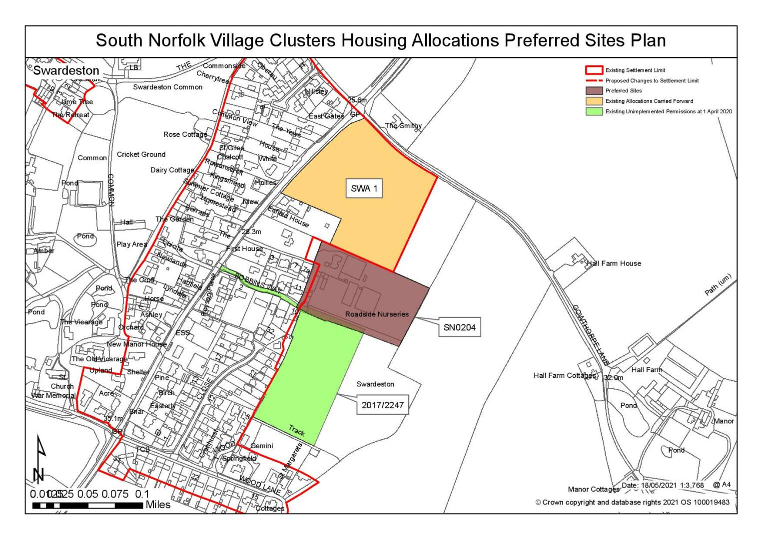
Swardeston
Swardeston has developed either side of the B1113, with outliers of development around The Common. The historic 'core' of the village is to the west of the main road where there are a number of older cottages facing The Common. More recent estate scale development has taken place to the east of the B1113.
The focus of the village is The Common which occupies some 21 hectares. There has been some limited infilling in the surrounding settlement groups but its character as a large, informal open space crossed by a network of unmade tracks has remained and contributes greatly to the pleasant rural character of the village. There is an outlier of development to the south of the road leading to Lower East Carleton. The landscape to the east of the village is open.
East Carleton
The parish is predominately rural with the main settlement having developed with frontage properties along Rectory Road, Hethersett Road and Wymondham Road.
Services and Community Facilities
The cluster possesses a good range of facilities which includes infant and junior schools, farm shop, GP surgery, social club, village hall and scout/guide hall, convenience stores, hot food take-aways, car MOT garage, pub and children's playgroup. The area has good access to Norwich via the B1113 and A140 and there is a regular bus service.
Settlement Limit and Constraints
Mulbarton and Bracon Ash
The Settlement Limit has been drawn to include the main built form of the settlement and include the allocated land. The village hall, Old Hall Farm and the church and rectory are excluded, but there are further small clusters of development with boundaries at the north and west of the common. In Bracon Ash, development at Poorhouse Lane, The Street and Hawkes Lane are included, but Mergate Farm and the small cluster of dwellings off Mergate Lane have been excluded. Infill
development opportunities have been created at The Rosery and Norwich Road in Mulbarton and at Hawkes Lane and the nurseries in Bracon Ash. An amendment is proposed to the Settlement Limit of Bracon Ash in order to exclude the triangular area of land used as a green. The Settlement Limit will also be amended to include recent planning permission 2017/2131. These changes are shown on the policies map.
Swardeston
The Settlement Limit has been drawn to include the main built form of the settlement and include the previously allocated land. The Settlement Limit is fragmented; the largest group along Main Road excludes Roadside Nursery and the larger residences around the church. In addition, there is a Settlement Limit around two groups of dwellings to the north and west of the common, on Intwood Lane and The Common. There is an opportunity for limited infill development on Intwood Lane. There are problems of surface water drainage particularly on the east side of the village and estate scale development would have to overcome this. No alterations are proposed to the existing Settlement Limit.
The existing primary school at Mulbarton is noted as operating at capacity. However there remains space in the nearest alternative at Newton Flotman. Further exploration will be needed to ensure primary school needs can be met.
(9) QUESTION 87: Do you agree with the extent of the Settlement Limit and any changes proposed? If not, please explain what further changes should be made.
Preferred and Shortlisted Sites
24 sites have been promoted for consideration, of which 2 were preferred for allocations but no further sites were shortlisted.
Preferred Sites
On the basis of the assessment undertaken the following site(s) have been identified as a preferred allocation:
|
Site: SN0204, Bobbins Way, Swardeston |
|
Preferred for up to 25 dwellings on a site of 1.6 hectares Reasoned justification: Promoted for a larger site of 3.3 hectares. As promoted the site is of a scale that would have a significant impact on the wider landscape. However, the site is considered suitable for allocation at a reduced scale of 1.6 hectares based on the Roadside Nurseries element of the site. Development would continue to have some adverse landscape impacts, due to identified flood risk constraints being likely to restrict development on those parts of the site closest to the existing settlement. This would resulting in a suboptimal relationship between new development and the main village. It would need to be demonstrated that a form of development could be achieved which relates suitably to the existing village. In order to mitigate highways concerns a development of more than 25 homes may be required. Should this be the case careful consideration would need to be given to mitigating landscape impact. |
|
|
(7) QUESTION 88: Do you support or object to the allocation of the preferred site? Please add additional comments to explain your response and please specify which site(s) you are referring to. If the site is allocated do you think there are any specific requirements that should be set out in the allocation policy?
|
Site: SN2038, South of Rectory Lane, Mulbarton |
|
Preferred for up to 35 dwellings on a site of 1.5 hectares Reasoned justification: The site is well located in terms of access to services and facilities. There are few constraints on the site. Whilst it would extend into the countryside, the site would be read largely against the backdrop of existing housing. Highways considerations mean that a smaller development at the southern end of the site, accessed from Bluebell Road, is the only appropriate option. |
|
|

(9) QUESTION 89: Do you support or object to the allocation of the preferred site? Please add additional comments to explain your response and please specify which site(s) you are referring to. If the site is allocated do you think there are any specific requirements that should be set out in the allocation policy?
Rejected Sites
The following site(s) were promoted for development but have been rejected on the basis of information available at the time of assessment.
|
Site |
Location and Reasons for Rejection |
|
SN0026SL |
Jasmine Cottage, The Street, Bracon Ash The site is backland development, out of keeping with the exiting settlement pattern, requiring a convoluted access and with potential amenity concerns for existing residents. Highways concerned about the suitability of the local road network. Surface water flood risk and potential loss off trees would also need to be addressed. |
|
SN0195 |
Land off the B1113 Norwich Road, Bracon Ash Poor relationship with existing development, both in terms of form and connectivity, as well as the erosion of gap between Bracon Ash and Mulbarton and the impact on the setting of Mulbarton Conservation Area. The current access is too narrow and visibility improvements appear to require third party land. Flood risk is a constraint, with most of the site in Zone 2 and parts in Zone 3a. |
|
SN0247 |
Site off Low Common, East Carleton Site not suitable for allocation or inclusion in settlement limit due to: remoteness from the services and facilities in Swardeston and Mulbarton, exacerbated by the lack of footways; out of keeping in terms of form and character; and possible deliverability issues, specifically regarding a suitable access |
|
SN0315 |
Land to the east of Mulbarton The wider site is significantly too large in the context of the Village Clusters document. No smaller parts of the site are considered suitable due to the poor relationship with existing settlement (i.e. detached by intervening fields), and the consequent townscape/landscape concerns. Whilst parts of the site are in close proximity to some local services and facilities, actual accessibility is much more limited due to the constraints of the local highway network. Areas of the site are also affected by surface water flood risk and heritage concerns. |
|
SN0367SL |
Land off Chesnut Close, Swardeston Not suitable for inclusion as a settlement limit extension due to impact on the character of the area, particularly The Common, and access constraints; the site has limited accessibility to local services and facilities, with many of the local roads having no footways. |
|
SN0426 |
Land to the west of Norwich Road, Swardeston The site is not considered suitable for allocation due to the separation from the main part of the settlement by the undeveloped grounds of Swardeston House; the site would impact adversely on both the landscape and townscape, an issue that would be emphasised by the loss of frontage vegetation to create a suitable access. Potential impact on the setting of the Grade II* Listed church, and adjoining listed Old Rectory, Old Vicarage and War Memorial. Pedestrian connectivity is also poor. |
|
SN0428SL |
Land north of Rectory Road, East Carleton East Carleton does not currently have a Settlement Limit to extend, and the site is at the margins of the acceptable distances to services, on roads that have very limited footway provision (and sections which are unlit and subject to the national speed limit). It is also not suitable due to harmful impact on the character of area that would result from the removal of the trees on site. |
|
SN0496REV |
Land north of Mulbarton 95 dwellings is larger than being sought in the VCHAP and it is not clear whether the 60 dwellings with a doctors surgery and care home would be (a) deliverable, or (b) possible to require. In any event, the site is detached from the rest of the settlement, and has both heritage concerns (impact on the listed church, Paddock Farm, and the Conservation Area) and landscape concerns (erosion of rural character from the public footpaths to the east). In terms of accessibility the site requires footways improvements to the B1113 and also to the footpath via the churchyard; however, a significantly reduced scheme would be unlikely to connect to the churchyard footpath and it is not clear what the B1113 junction arrangement would be for a smaller scheme. |
|
SN0517SL |
Land off The Common, Swardeston Not suitable for inclusion as a settlement limit extension due to impact on the character of the area, particularly The Common, and access constraints. Neither of the adjoining small groups of dwellings are within the Settlement Limit. The site has limited accessibility to local services and facilities, with many of the local roads having no footways. |
|
SN0549SL |
Barracks Meadow, Hawkes Lane, Bracon Ash Not suitable for allocation or a settlement limit extension of the scale proposed, which would be out of keeping with the form and character of the location and have potential heritage concerns re Home Farm House and Mergate Farm. Access is along the narrow Hawkes Lane, with no footways and limited visibility at bends. |
|
SN0551 |
Land to the rear of Almond Villa, Intwood Lane, Swardeston The site is at the limits in terms of distances to services and the roads around the site are narrow, unlit, with no footways, making walking/cycling an unattractive option. The site would be backland development, out of keeping with the frontage only development at present and may also have amenity implications. The main concern with this site is the inability to create a suitable access. |
|
SN0600REV |
Land to the east of Hethersett Road, East Carleton This is not suitable as a settlement limit extension or allocation for housing, given the considerable distance from all of the main services and the intrusion into countryside, which would generally be out of keeping with this rural location. |
|
SN1037 |
The Old Nursery, The Drift, Lower East Carleton The site not suitable for allocation or inclusion in settlement limit due to remoteness from key services and facilities and the narrow roads with no footways between the site and Swardeston/Mulbarton (including stretches under the national speed limit). The site does not appear to have direct access to the adopted highway, instead being accessed via the unadopted The Drift. Even at a reduced site size, development in this location would form a largely isolated group of dwellings in the countryside. |
|
SN1058 |
Land east of Swallow Barn, Wymondham Road, East Carleton A previous refused application has demonstrated that the site has limited constraints and that a suitable access could be achieved; however the site is beyond the required distance to services for everything other than local employment, and the routes to Mulbarton generally have no footways and sections at the national speed limit. The site is part of a small group of buildings, detached from East Carleton village, and not suitable for a Settlement Limit as intensifying development here would erode the rural character of the area. |
|
SN1059SL |
Land at Paddock Cottage, Swardeston Lane, East Carleton A previous permission for a single dwelling on this plot has been implemented, which now makes further development difficult to achieve in terms of access and form of development (which would be piecemeal backland). Notwithstanding this, the site is at the limit in terms of distance to services/facilities, and beyond 3km from Mulbarton Primary School. This location currently does not have a settlement limit and is not considered appropriate for a new settlement limit, which would encourage intensification of development in a rural location with generally poor access to services/facilities. |
|
SN2039 |
Land north of Rectory Lane, Mulbarton The site is well located in terms of distance to services and facilities. However, the access using Rectory Lane is not appropriate (narrow, unlit, lack of footways). In townscape/heritage terms, estate style development would be out of keeping with the rural character of Rectory Lane with potential impacts on the setting of nearby listed properties. Loss of the intact hedge closest to the village to create any access/visibility would also be a concern. |
|
SN2087 |
South of Cuckoofield Lane, Bracon Ash The site is relatively well located in terms of the distance to local services and facilities. However, the site would diminish the small gap separating the settlements of Bracon Ash and Mulbarton. The irregular shape of the site, and the presence of TPO trees would constrain development. The access as proposed via the Local Plan submission is very narrow and would have amenity implications for occupiers of the adjoining properties. An alternative access was proposed via the withdrawn application however this would involve taking a road through the boundary hedge into the agricultural field to the east of Park Nook, which would have a further urbanising effect. |
|
SN2165 |
Land south of Wymondham Road, East Carleton Not suitable for an allocation due to remote location beyond the required distance to services for everything other than local employment, and the routes to Mulbarton generally have no footways or lighting and sections at the national speed limit. Development would represent an isolated group of dwellings in the countryside, eroding the rural character, which would be further diminished by the loss of hedgerow to create an access |
|
SN2167REV |
Land east of Hethersett Road, East Carleton This is not suitable as a settlement limit extension or allocation for housing, given the considerable distance from all of the main services and the intrusion into countryside. Development would represent an isolated group of dwellings in the countryside, eroding the rural character. |
|
SN4032 |
Land east of Norwich Road, Bracon Ash Although the site could potentially form an extension to the existing BRA1 Local Plan allocation, it would become significantly more intrusive in the open landscape and encroach into the rural setting of the listed Home Farm House. There would also be significant highways concerns about further development in this location, including safe non-car access to local services and facilities in Mulbarton. |
|
SN4059 |
Corner of Brick Kiln Lane, Mulbarton The site is reasonably well located in terms of distance to services and facilities and has few on-site constraints. However, access using The Rosery is not appropriate as the road is narrow, unlit, lacks footways, and has a constrained junction with Long Lane/Cuckoofield Lane. The site would also have a poor relationship with existing development, particularly as there is no obvious connectively with the recently completed housing off Long Lane. |
|
SN4082 |
Land at Intwood Lane, Swardeston The site is at the limits in terms of distances to services and the roads around the site are narrow, unlit, with no footways, making walking/cycling an unattractive option. Development of the site would erode the rural character of the area, impacting on the higher plateau landscape and encroaching into an undeveloped part of the Southern Bypass Landscape Protection Zone. |
|
SN4086 |
Land south of Rectory Road, East Carleton The site itself has few constraints and frontage development would be in keeping with the form and character of the settlement, subject to assessment of the trees along Rectory Road. However, the site is beyond of the required distances to most services/facilities, on roads that have very limited footway provision (and sections which are unlit and subject to the national speed limit). |
(12) QUESTION 90: Do you think that any of the rejected sites should be allocated instead of, or in addition to, the preferred site? Please add additional comments to explain your response and please specify which site(s) you are referring to.
To find out more about the Village Clusters Housing Allocations Plan, please visit our Virtual Exhibition.