
South Norfolk Village Clusters Housing Allocations Plan (Reg. 18 Draft)
48. Wrenningham, Ashwellthorpe and Fundenhall
Form and character
Wreningham
The village centre is linear, with ribbon development following Church Road, Wymondham Road and Ashwellthorpe Road, with a pocket of further development along Mill Lane. The primary school is located centrally where the four roads meet, and further along Mill Lane at the Norwich Road junction is the hamlet of Toprow.
The village is surrounded by large open fields interspersed with hedgerows and a few trees. Toprow lies along a shallow valley. Narrow lanes and mature trees contribute to the village's rural atmosphere. The B1113 provides a direct link to Norwich.
Ashwellthorpe & Fundenhall
The main concentration of development has taken place along both sides of The Street resulting in a predominantly linear settlement. A further ribbon of development extends at the western end of The Street, southwards on New Road. Some estate development has taken place at Knyvett Green and Greenwood Close on the south of The Street. To the north of The Street is Lower Wood, a large wooded area (and SSSI) forming an attractive backdrop to the village and contributing to the rural character and setting of the village. Good road links exist to Wymondham on the B1135 and Norwich via the B1135 and A11.
Services and Community Facilities
Facilities include a preschool, primary school, village hall, recreation facilities and pub. There is also a limited bus service.
Settlement Limit and Constraints
Wreningham
The Settlement Limit has been drawn to include the main built form of the settlement- The Settlement Limit covers most development along Wymondham Road, Ashwellthorpe Road and Church Road, up to the junction at Hethel Road as well as limited infill on Church Road. The existing Settlement Limit has been extended to the west along Wymondham Road to include the three dwellings granted planning permission by 2018/2301. The clusters of development to the east of the church and to the north-east of Hethel Road are excluded from the Settlement Limit. The separate Settlement Limit at Mill Lane/Toprow includes most of the cluster of dwellings in that location and has been altered to allow limited infill. The road capacity of the village is a limiting factor. The South Norfolk Place-making Guide suggests that in this area the nucleated clustered character of the settlements is maintained.
Ashwellthorpe
The Settlement Limit has been drawn to include the main built form of the settlement, but there are two breaks at Wood Farm and Church Farm. Planning permission 2011/0506 is still being built out. The permission site is not included within the Settlement Limit as this could risk its delivery. The site will be included within future iterations of the Settlement Limit when it is built out.
No alterations are proposed to the existing settlement limits within this cluster.
It is noted that Wreningham Primary School is operating at capacity. However, the nearest alternative at Hapton has space. Further exploration will be needed to ensure primary school needs can be met.
(10) QUESTION 170: Do you agree with the extent of the Settlement Limit and any changes proposed? If not, please explain what further changes should be made.
Preferred and Shortlisted Sites
15 sites have been promoted for consideration, 3 of which were identified as preferred allocation sites. No further sites were shortlisted.
Preferred Sites
On the basis of the assessment undertaken the following site(s) have been identified as a preferred allocation:
|
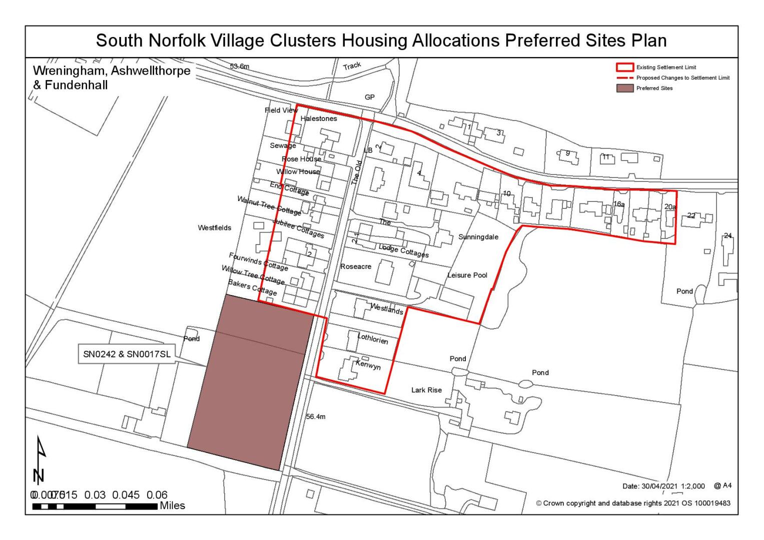
Site: SN0017SL - Land to the west of New Road, Ashwellthorpe & SN0242 - Land to the west of New Road, Ashwellthorpe |
|
Preferred for an allocation of 12 dwellings on a site of approximately 0.89 hectares. Reasoned justification: Site SN0017SL is preferred in combination with site SN0242 to enable allocation scales of development, including affordable housing. Whilst the site does not have direct footpath links to the school it is relatively well related to the nearby village hall, recreation ground and public house. The site is well contained within the existing field boundaries and is not considered to have a significant detrimental impact on the wider landscape. It would reflect the existing character of development and would read as an extension to the village. It is expected that the development of the site would require removal of some frontage hedge as carriageway widening and footways would be required. The scale of hedgerow loss could be reduced if access is gained towards the southern end of the site. |
|
|
(6) QUESTION 171: Do you support or object to the allocation of the preferred site? Please add additional comments to explain your response and please specify which site(s) you are referring to. If the site is allocated do you think there are any specific requirements that should be set out in the allocation policy?
|
Site: SN2183 - Land south of Wymondham Road, Wreningham |
|
Preferred for up to 25 dwellings on a site of 1.1 hectares Reasoned justification: It is adjacent to the settlement limit and close to the school and although the route has no footpath it is within the village 30mph speed restriction where there is already pedestrian movement and some verges. The size of the site is out of scale and character with the village as promoted, 2.1ha (52 dwellings) however, a reduced site area would relate to the existing settlement and read as part of the existing built form. It could be frontage development possibly with a small cul-de-sac to mirror the development on the opposite side of the road. It could be contained by substantial planting to the west so that it would not encroach significantly into the countryside to the south. It would require the removal of a frontage hedge line for access and the ditches and surface water would need to be addressed. There is a highway safety concern with access visibility onto The Street and the junction at Church Road and the development of the site would be subject to addressing these highway constraints. |
|
|

(26) QUESTION 172: Do you support or object to the allocation of the preferred site? Please add additional comments to explain your response and please specify which site(s) you are referring to. If the site is allocated do you think there are any specific requirements that should be set out in the allocation policy?
Rejected Sites
The following site(s) were promoted for development but have been rejected on the basis of information available at the time of assessment.
|
Site |
Location and Reasons for Rejection |
|
SN0009SL |
Top Row The site is not close to any Settlement Limit and is very remote from services. It has very poor connectivity to the school along narrow, unlit roads with no footpaths and across the B1113. This also results in highway safety concerns because Top Row is limited in width and has substandard visibility into Norwich Road. It would be a significant intrusion within the landscape to the south and it is constrained by a TPO and flood risk to the south. |
|
SN0013SL REV |
New Road It is remote from the school and other services with poor connectivity along narrow, unlit roads with no footpaths. Development here is sporadic and as the site is physically and visually separate from the existing village it would be a significant intrusion in the wider landscape as it breaks into the open countryside to the south-west. Possible surface water flooding. |
|
SN0093 |
Field 2484, w/o All Saints Church at junction of Hethel Road & Church Road It has poor connectivity to the school along narrow, unlit roads with no footpaths. This also results in highway safety concerns because of the poor visibility at the Church Road junction. The site is prominent at this junction and would have a negative impact on the adjacent Listed church and its setting. It would be an intrusion within the landscape encroaching beyond a natural edge of the settlement and access would require the removal of a strong frontage hedge line. |
|
SN0187 |
Land adjacent to Rosko, north of Wymondham Road Although it is close to the school it has poor connectivity along a narrow road with no footpaths and limited verges. The size of the site is out of scale with the village, 2.04ha (51 dwellings) but could be reduced in scale. It is also out of character as it would be contrary to the existing settlement pattern of linear development and would encroach into the countryside to the north with significant detriment to the landscape setting of the village. There is an issue with access as it has been blocked by the recent frontage development. |
|
SN0213 |
Timber Yard, The Street It is remote from the school although it is close to the limited services of the village hall and pub. The site does not have a road frontage, except for access, and would be a significant breakout to north which would be out of character with the surrounding townscape. The narrow access may require third party land to widen it and provide a footway and increased use could have a detrimental impact on adjoining residential properties. Ecological impacts would need careful consideration given the ancient woodland/SSSI to the north. |
|
SN0233 |
Rose Farm, The Street It is remote from the school although it is close to the limited services of the village hall and pub. There is extant permission for 7 dwellings on a slightly smaller area and an increase in site area or numbers would be out of character with the surrounding density and have a greater negative impact on the townscape. Ecological impacts would need careful consideration given the ancient woodland/SSSI to the north. |
|
SN0234REV |
Land adjacent to Rose Farm, The Street It is remote from the school but it is close to the limited services of the village hall and pub. It would be a further significant breakout to north which would be out of character with the surrounding density and have a greater negative impact on the townscape. Ecological impacts would need careful consideration given the ancient woodland/SSSI to the north and providing access and widening the footway would require the removal of all the frontage hedge. |
|
SN0236SL |
Land to rear of 47 The Street It is remote from the school although it is close to the limited services of the village hall and pub. It does not have a road frontage, except for a narrow access, and would be a significant breakout to north beyond existing tree lines which would be out of character with the surrounding townscape. The very narrow access may require third party land to widen it and provide a footway which would have a detrimental impact on adjoining residential properties. Ecological impacts would need careful consideration given the ancient woodland/SSSI to the north. |
|
SN0239 |
Land at New Road The site is next to the settlement limit but is remote from the school although relatively close to the village hall, recreation ground and public house. It is contained within the existing field boundaries but would have a negative impact on the wider landscape as it would encroach beyond existing development to the east and require removal of significant frontage hedge as carriageway widening and footways would be required. |
|
SN0431 |
Land south of Hethel Road The smaller size of the site is more appropriate than SN0431REV, however it is still considered to be unreasonable. The site has poor connectivity to the school along narrow, unlit roads with no footpaths. This also results in highway safety concerns because of the blind bend and poor visibility at the Church Road junction. It is out of character as Hethel Road only has sporadic development to the north and comparatively this would be a large increase. This site is prominent to the south and would be a significant intrusion within the landscape requiring the removal of a strong frontage hedge line for access. |
|
SN0431REV |
Land south of Hethel Road It has poor connectivity to the school along narrow, unlit roads with no footpaths. This also results in significant highway safety concerns because of the blind bend and poor visibility at the Church Road junction. The size of the site is out of scale with the village, 2.8ha (70 dwellings), although it could be reduced in size. It is also out of character as Hethel Road only has sporadic development to the north. This site is prominent to the south and would be a significant intrusion within the landscape requiring the removal of a strong frontage hedge line for access. |
|
SN0598REV |
Land east of New Road It is remote from the school and other services with poor connectivity along narrow, unlit roads with no footpaths. It is a large site which is out of character with the village particularly as development here is sporadic. The site is physically and visually separate from the existing village and it would be a significant intrusion in the wider landscape as it breaks into the open countryside to the south-east. Surface water flooding may occur. |
(3) QUESTION 173: Do you think that any of the rejected sites should be allocated instead of, or in addition to, the preferred site? Please add additional comments to explain your response and please specify which site(s) you are referring to.
To find out more about the Village Clusters Housing Allocations Plan, please visit our Virtual Exhibition.