
South Norfolk Village Clusters Housing Allocations Plan (Reg. 18 Draft)
35. Stoke Holy Cross, Shotesham and Caistor St Edmund & Bixley
Form and character
Stoke Holy Cross
Within the parish of Stoke Holy Cross there are two main areas of settlement, the main village lying astride the C201 road connecting Norwich and Hempnall in the west of the parish, and the settlement of Upper Stoke which lies on its eastern boundary. This latter area forms part of the settlement of Poringland and is covered by the Poringland Settlement Limit.
Historically the village developed around the mill which forms the principal building in the small conservation area which was designated in 1975. The village has traditionally had a strongly linear form which developed along the eastern banks of the River Tas away from the older historic part of the settlement around the mill. More recent estate development has taken place on the eastern side of Norwich Road where the village has grown up the slope of the valley.
Shotesham
Development within the parish has been concentrated along the Street to form the established village of Shotesham. The village has developed a linear settlement form with one plot depth only. The whole village is set within an attractive valley landscape with a particular feature being the abundance of trees and hedges which fill the significant gaps that separate many of the buildings and therefore are important in maintaining the rural character of the village.
The main built-up area together with part of Shotesham Common is a conservation area, designated since 1973. This was extended in 1994 to include the attractive landscape to the west associated with Shotesham Hall.
Caistor St Edmund and Bixley
Caistor St Edmund is situated in the Tas Valley and is the site of the remains of a Roman market town. Development within the parish is sparsely populated with development concentrated along Stoke Road and Caistor Lane and the remainder of the parish displaying a dispersed settlement pattern of individual dwellings. The parish is located close to the A140 and A47 allows good access to Norwich and further afield.
Bixley is predominately rural in nature with isolated dwellings. The B1332 allows good access to the south towards Poringland, but also to the north to A146 and A47.
Services and Community Facilities
The cluster possesses a wide range of facilities, including a primary school and a pre-school, pub, village hall and recreation facilities including a skate park. The C201 provides a direct link from the village to Norwich are there are bus links. This road crosses over the A47 Norwich Southern Bypass, but no access on to the A47 is provided at this point and therefore traffic wishing to access the A47 either has to go via the Norwich Ring Road, Poringland or Dunston, the latter being unsuitable to any increase in traffic due to the narrow nature of the lanes through Dunston to the A140.
Settlement Limit and Constraints
Stoke Holy Cross
The Settlement Limit has been drawn to include the main built form of the settlement and recent new housing development. The boundary allows for additional infill development on Long Lane and elsewhere in the village but has been drawn to protect the more rural character of the village in the southern and northern extremities of development along Norwich Road.
There remains capacity within Stoke Holy Cross primary school. It is noted however that the school admits from a wider area that is growing. Further exploration will be needed to ensure primary school needs can be met.
Shotesham
Due to the limited services available and the attractive valley landscape the Settlement Limit has been drawn around the existing built up area to prevent further ribbon development extending into the surrounding countryside. The area from the walled frontage of Shotesham House and the Old Barn southwards along The street has been excluded from the Settlement Limit because of the importance this area has in contributing towards the form of the village. Any proposals for new development within the boundary must take account of the character of the well-established conservation area and positively enhance it.
No alterations are proposed to the existing settlement limits within this cluster.
(3) QUESTION 123: Do you agree with the extent of the Settlement Limit and any changes proposed? If not, please explain what further changes should be made.
Preferred and Shortlisted Sites
9 sites have been promoted for consideration, of which 1 has been identified as a preferred allocation site. No further sites were shortlisted.
Preferred Sites
On the basis of the assessment undertaken the following site(s) have been identified as a preferred allocation:
|
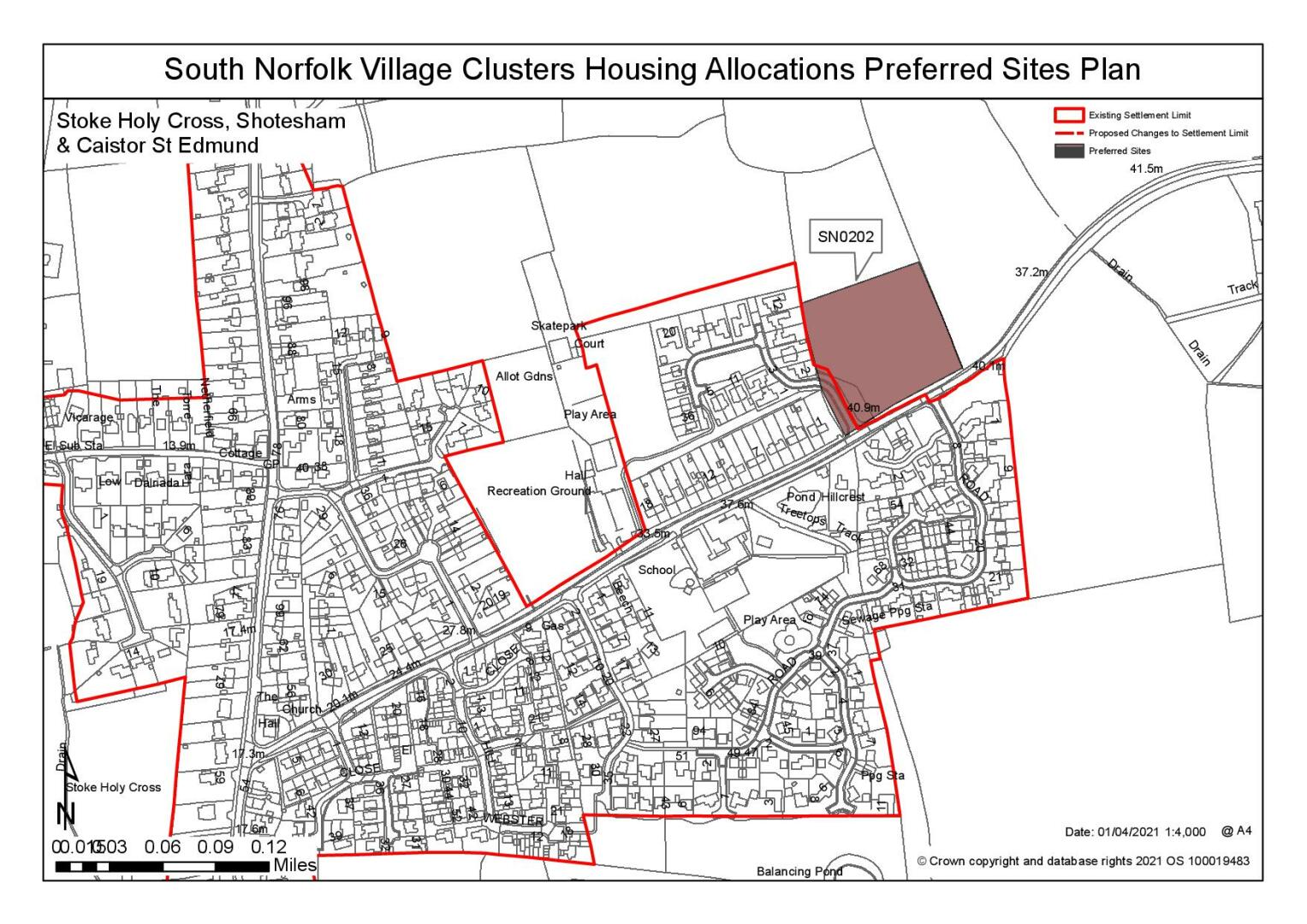
Site: SN0202, Land north of and adjoining Long Lane, Stoke Holy Cross |
|
Preferred for up to 25 dwellings on a site of 1.3 hectares. Reasoned justification: The site relates well to the existing settlement and benefits from good access to the local services. Access to the site would be achievable and off-site highway works could reasonably address the highways issues identified. However, development of this site would have an impact on the wider landscape setting, in particular in long views across the Tas Valley, and this would be difficult to mitigate. |
|
|
(9) QUESTION 124: Do you support or object to the allocation of the preferred site? Please add additional comments to explain your response and please specify which site(s) you are referring to. If the site is allocated do you think there are any specific requirements that should be set out in the allocation policy?
Rejected Sites
The following site(s) were promoted for development but have been rejected on the basis of information available at the time of assessment.
|
Site |
Location and Reasons for Rejection |
|
SN0197 |
Land north of Long Lane, Stoke Holy Cross The site is well connected to the settlement, however there are significant highways concerns about access into the site. Concerns have also been raised about the existence of a ransom strip between this site and the adjacent development have been raised which could affect deliverability. Significant landscape concerns have also been raised in respect of the impact that further development in this location could have on the wider views across the Tas Valley. If it can be demonstrated that highway concerns can be overcome and a scheme that is acceptable in landscape terms is achievable then this site might be viewed as being reasonable, but this conclusion cannot be drawn at this point. |
|
SN0524 |
Land south of Long Lane, Stoke Holy Cross An overall reduction in size could address concerns about the scale of development proposed. However, there would remain landscape concerns about further eastward extension of the village in the river valley landscape and in respect of highways safety matters, including ongoing speed compliance issues and the difficulties creating a safe pedestrian footpath to the south. |
|
SN0532 |
Land east of Norwich Road, Caistor St Edmund The site has poor connectivity and is remote from services, including the local primary school. Other identified constraints include highways access, residential amenity and potential landscape issues. |
|
SN0534 |
Land north of The Street, Shotesham The site is poorly connected to the local services, including the local primary school. Development of the site would have an impact on the historic environment, including Listed Buildings and the Conservation Area. |
|
SN0590 |
Land north of The Street, Shotesham The site is poorly connected to local services, including the local primary school. Development of the site is proposed to retain the existing playing field however it would result in the loss of the existing trees and hedgerows along the road frontage to create an acceptable access. Development of this site would therefore also have a harmful impact on the local landscape character, the townscape and the Conservation Area. |
|
SN2091 |
Land of Norwich Road, Stoke Holy Cross Whilst the site benefits from good connectivity and no significant highways concerns have been identified, the site forms an important gateway to the settlement and development of the scale proposed would have a harmful impact on both the landscape and townscape setting. It would also contrast with the existing loose pattern of development in this location. Heritage concerns have also been identified due to the proximity of the site to the Grade II* Church of Holy Cross. |
|
SN4013 |
Land to North East of Shotesham Road, Shotesham Constraints have been identified. These include the impact it would have on the landscape character of the area, the impact on the Conservation Area of Shotesham and the overall poor connectivity of the site to local services. |
|
SN4028 |
Land at Highview, The Common, Shotesham The site is poorly connected to the local services, including the primary school, and development in this location would have a significant impact on a sensitive landscape setting due to the changes in topography of the site. The landscape impact of development in this location could not reasonably be mitigated. |
(5) QUESTION 125: Do you think that any of the rejected sites should be allocated instead of, or in addition to, the preferred site? Please add additional comments to explain your response and please specify which site(s) you are referring to.
To find out more about the Village Clusters Housing Allocations Plan, please visit our Virtual Exhibition.